Local Government
Coolgardie
Region
Goldfields
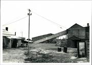
Battery Rd Coolgardie
SE of Coolgardie, off the Coolgardie-Esperance Highway, off Norseman Rd.
Coolgardie
Goldfields
Constructed from 1902
| Type | Status | Date | Documents |
|---|---|---|---|
| State Register | Registered | 22 Jun 2001 | HCWebsite.Listing+ListingDocument, HCWebsite.Listing+ListingDocument |
| Type | Status | Date | Documents |
|---|---|---|---|
| (no listings) |
| Type | Status | Date | Grading/Management | |
|---|---|---|---|---|
| Category | ||||
| Classified by the National Trust | Classified | 27 Oct 1976 | ||
| Register of the National Estate | Permanent | 21 Mar 1978 | ||
| Municipal Inventory | Adopted | 27 Jul 1995 | Category 1 | |
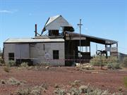
Industrial buildings with timber frames, clad in corrugated iron. The buildings have been on site since 1902, though the machinery has been upgraded several times, from steam power to gas to oil and finally to electricity.
Individual Building or Group
| Epoch | General | Specific |
|---|---|---|
| Present Use | MINING | Mining Battery |
| Original Use | MINING | Mining Battery |
| Type | General | Specific |
|---|---|---|
| Roof | METAL | Corrugated Iron |
| Wall | METAL | Corrugated Iron |
| General | Specific |
|---|---|
| OCCUPATIONS | Mining {incl. mineral processing} |
This information is provided voluntarily as a public service. The information provided is made available in good faith and is derived from sources believed to be reliable and accurate. However, the information is provided solely on the basis that readers will be responsible for making their own assessment of the matters discussed herein and are advised to verify all relevant representations, statements and information.
A representative industrial building form, housing an operation associated with goldmining and still in operation as a battery
The buildings are still the original ones, built in 1902. The machinery has been updated several times, converting from steam to gas to oil and then to electricity. The buildings are simple timber framed, corrugated iron lined industrial buildings designed for their particular functions; eg: stockpiles, crushing ore and extracting gold
Assessment 1976 Construction: 1902
This information is provided voluntarily as a public service. The information provided is made available in good faith and is derived from sources believed to be reliable and accurate. However, the information is provided solely on the basis that readers will be responsible for making their own assessment of the matters discussed herein and are advised to verify all relevant representations, statements and information.
Constructed from 1902
A representative industrial building form of historical significance, still performing the same gold extraction function for which it was built in 1902, and reflecting the mining history of Coolgardie.
The buildings are the original ones dating from 1902, comprising simple timber framed, corrugated iron lined industrial structures designed for their particular functions, ie stock pilling and crushing ore and extracting gold. The machinery has been updated several times, converting from steam to gas to oil and then to electricity.
One of a number of state built batteries and one of the few intact and remaining in operation.
High
Fair
| Ref ID No | Ref Name | Ref Source | Ref Date |
|---|---|---|---|
| National Trust Citation | |||
| Webb, M&A "The Centennial History of Kalgoorlie-Boulder" | 1993 |
| Owner | Category |
|---|---|
| I. Kean | Other Private |
This information is provided voluntarily as a public service. The information provided is made available in good faith and is derived from sources believed to be reliable and accurate. However, the information is provided solely on the basis that readers will be responsible for making their own assessment of the matters discussed herein and are advised to verify all relevant representations, statements and information.
47km SSE of Kalgoorlie, White Hope Mine access rd via Wollubar Station Kambalda
accessed from the White Hope Mine access road through Wollubar Station, Kambalda
Kalgoorlie-Boulder
Goldfields
Constructed from 1901 to 1902
| Type | Status | Date | Documents |
|---|---|---|---|
| State Register | Registered | 13 May 2005 | HCWebsite.Listing+ListingDocument, HCWebsite.Listing+ListingDocument |
| Type | Status | Date | Documents |
|---|---|---|---|
| (no listings) |
| Type | Status | Date | Grading/Management | |
|---|---|---|---|---|
| Category | ||||
| Municipal Inventory | Adopted | 27 Jul 1995 | Category 2 | |
King Battery is essentially stable and, with the exception of some details of the chimney stack base and the tailings wheel pillars, in very good condition for a site of its type.
| Library Id | Title | Medium | Year Of Publication |
|---|---|---|---|
| 5118 | King Battery conservation plan / G. MacGill ; prepared for the Eastern Goldfields Historical Society. | Heritage Study {Cons'n Plan} | 2001 |
Individual Building or Group
| Epoch | General | Specific |
|---|---|---|
| Original Use | INDUSTRIAL\MANUFACTURING | Refinery or Smelter |
| Present Use | INDUSTRIAL\MANUFACTURING | Refinery or Smelter |
| Original Use | MINING | Mining Battery |
| Style |
|---|
| Other Style |
| Type | General | Specific |
|---|---|---|
| Wall | STONE | Local Stone |
| General | Specific |
|---|---|
| DEMOGRAPHIC SETTLEMENT & MOBILITY | Resource exploitation & depletion |
| OCCUPATIONS | Commercial & service industries |
This information is provided voluntarily as a public service. The information provided is made available in good faith and is derived from sources believed to be reliable and accurate. However, the information is provided solely on the basis that readers will be responsible for making their own assessment of the matters discussed herein and are advised to verify all relevant representations, statements and information.
This information is provided voluntarily as a public service. The information provided is made available in good faith and is derived from sources believed to be reliable and accurate. However, the information is provided solely on the basis that readers will be responsible for making their own assessment of the matters discussed herein and are advised to verify all relevant representations, statements and information.

Cnr Stirling Hwy & Boundary Rd Mosman Park
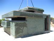
INCLUDES: cpmplex of underground tunnels, rooms & observation post, semi buried command post, 2 x 6 inch gun emplacements, 2 x 5.25 inch gun emplacements (one buried), radar hut, access road, limestone retaining walls, and surrounding public open space
Buckland Hill Tunnels
Citizen Military Force Training Battery
Mosman Park
Metropolitan
Constructed from 1942 to 1990
| Type | Status | Date | Documents |
|---|---|---|---|
| Heritage List | Adopted | 02 Sep 2014 | |
| State Register | Registered | 27 Aug 1999 | HCWebsite.Listing+ListingDocument, HCWebsite.Listing+ListingDocument |
| Type | Status | Date | Documents |
|---|---|---|---|
| (no listings) |
| Type | Status | Date | Grading/Management | |
|---|---|---|---|---|
| Category | ||||
| Register of the National Estate | Registered | 22 Jun 1993 | ||
| Classified by the National Trust | Classified | 13 May 1996 | ||
| Aboriginal Heritage Sites Register | Recorded | |||
| Municipal Inventory | Adopted | 24 Mar 1998 | Category 1 | |
| Library Id | Title | Medium | Year Of Publication |
|---|---|---|---|
| 11922 | Leighton Battery Interpretation plan | Heritage Study {Other} | 2015 |
| 11779 | Buckland Hill | Heritage Study {Cons'n Plan} | 2020 |
Historic Site
| Epoch | General | Specific |
|---|---|---|
| Original Use | MILITARY | Fort or Gun Emplacement |
| Present Use | EDUCATIONAL | Museum |
| Other Use | MILITARY | Other |
| Present Use | SOCIAL\RECREATIONAL | Other |
| Style |
|---|
| Other Style |
| Type | General | Specific |
|---|---|---|
| Wall | BRICK | Common Brick |
| Other | CONCRETE | Other Concrete |
| Other | TIMBER | Other Timber |
| General | Specific |
|---|---|
| OUTSIDE INFLUENCES | World Wars & other wars |
| SOCIAL & CIVIC ACTIVITIES | Sport, recreation & entertainment |
| SOCIAL & CIVIC ACTIVITIES | Education & science |
| SOCIAL & CIVIC ACTIVITIES | Community services & utilities |
This information is provided voluntarily as a public service. The information provided is made available in good faith and is derived from sources believed to be reliable and accurate. However, the information is provided solely on the basis that readers will be responsible for making their own assessment of the matters discussed herein and are advised to verify all relevant representations, statements and information.
Constructed from 1945, Constructed from 1942
The Leighton Battery was the only battery using 5.25inch dual role Coast Artillery/Air Defence weapons to come into service in Australia. It is now one of the only two 5.25inch battery locations remaining relatively intact int he world.
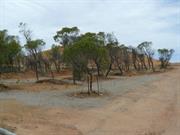
Located high on Buckland Hill, the Leighton Battery site is fairly unobtrusive as much of the construction is underground. A metal lookout platform, a gun, a gun placement and tunnel entrances are limestone retaining walls, and walking paths circle the hill. Vegetation is low scrub and grasses, mostly native but some introduced. The site looks over the Indian Ocean to Rottnest Island, to Fremantle Harbour, over many surrounding suburbs, to the obelisk on the east and beyond the to the Perth city skyline.
Constructed during World War 2 to improve defence of Fremantle Harbour. Originally had over 400 metres of tunnels linking ammunition magazines, a workshop, rest areas, an aid post and the observation/command post. Wartime records suggest that no rounds were ever fired in anger by this Battery. Guns were upgraded between 1945 and 1947. Site was used for training. Battery was disbanded in 1963 and all equipment including guns were sold for scrap. Site neglected until residential redevelopment in the mid 1980s. Site gradually restored since then. Opened as a museum on 29/11/1997
Most of the original surface structures have been demolished. Some of the underground structures have been filled. Partially restored during 1980s and 1990s.
Good
| Ref ID No | Ref Name | Ref Source | Ref Date |
|---|---|---|---|
| Tuettemann, E | Between River and Sea p. 197-9 | 1991 | |
| The Royal Australian Artillery Historical Society of Western Australia | Leighton Battery Royal Australia Artillery | ||
| Australian Heritage Commission. Register of the National Estate Database Place Report | |||
| National Trust Assessment | 1996 |
| Ref Number | Description |
|---|---|
| 004 | Municipal Inventory number |
| Reserve | Lot/Location | Plan/Diagram | Vol/Folio |
|---|---|---|---|
| A41749 / 455 |
This information is provided voluntarily as a public service. The information provided is made available in good faith and is derived from sources believed to be reliable and accurate. However, the information is provided solely on the basis that readers will be responsible for making their own assessment of the matters discussed herein and are advised to verify all relevant representations, statements and information.
7 Forts Rd Mount Clarence
3/10/2011 Address includes: Lot 1377 Forts Road, Mount Clarence. VFL.
Nissen Hut
Princess Royal Battery/Barracks
Albany
Great Southern
Constructed from 1893 to 1939
| Type | Status | Date | Documents |
|---|---|---|---|
| Heritage List | Adopted | 27 Oct 2020 | |
| State Register | Registered | 29 Nov 1996 | HCWebsite.Listing+ListingDocument, HCWebsite.Listing+ListingDocument |
| Type | Status | Date | Documents |
|---|---|---|---|
| (no listings) |
| Type | Status | Date | Grading/Management | |
|---|---|---|---|---|
| Category | ||||
| Classified by the National Trust | Classified | 15 Nov 2004 | ||
| Municipal Inventory | Adopted | 30 Jun 2001 | Category A+ | |
| Local Heritage Survey | Adopted | 27 Oct 2020 | Exceptional | |
| Statewide Lge Timber Str Survey | Completed | 11 Dec 1998 | ||
| Register of the National Estate | Permanent | 22 Jun 1993 | ||
| Classified by the National Trust | Classified | 13 Dec 2004 | ||
| Library Id | Title | Medium | Year Of Publication |
|---|---|---|---|
| 6409 | Princess Royal Fortress, Albany : conservation plan. | Heritage Study {Cons'n Plan} | 2002 |
| 9731 | Great Southern strategic plan for Maritime heritage tourism. The story of the sea in the South. | Report | 2010 |
| 7676 | Princess royal fortress Albany: interpretation plan, final draft. | Heritage Study {Other} | 2004 |
| 7881 | Albany: spectacular! | Brochure | 0 |
| 1927 | Albany and surrounds : data relating to items of heritage significance. | Heritage Study {Other} | 1980 |
| 9231 | A sound defence: The story of Princess Royal Fortress King George III Sound Western Australia. | Book | 1983 |
| 1944 | Albany heritage park : draft management plan. | Report | 1987 |
| 7736 | Draft City Mounts management plan: Mount Melville, Mount Clarence, Mount Adelaide and Bluff Rock. | Report | 2005 |
| 1928 | Conservation development and managment programme for the Albany forts Final report | Report | 1984 |
Individual Building or Group
| Epoch | General | Specific |
|---|---|---|
| Original Use | MILITARY | Fort or Gun Emplacement |
| Present Use | EDUCATIONAL | Other |
| Style |
|---|
| Victorian Georgian |
| Type | General | Specific |
|---|---|---|
| Wall | STONE | Granite |
| Wall | BRICK | Common Brick |
| Roof | METAL | Zincalume |
| Wall | METAL | Zincalume |
| Other | TIMBER | Slab |
| Wall | CONCRETE | Other Concrete |
| Wall | TIMBER | Weatherboard |
| General | Specific |
|---|---|
| OUTSIDE INFLUENCES | World Wars & other wars |
This information is provided voluntarily as a public service. The information provided is made available in good faith and is derived from sources believed to be reliable and accurate. However, the information is provided solely on the basis that readers will be responsible for making their own assessment of the matters discussed herein and are advised to verify all relevant representations, statements and information.
Constructed from 1891 to 1893
The place has a high degree of aesthetic value due to its prominent position in the harbour and its relatively undisturbed natural landscape, as well as its close association with the Mt Clarence Parklands. Its current use as a military heritage park lends added aesthetic value to the surrounding grounds and parklands. The area has historical significance for its role in the first national strategy to defend Australia, as well as providing an example of pre-Federation co-operation between states that continued through two world wars. The Fortress itself holds the position of being the first fortress constructed in Western Australia for the purpose of defending a harbour and is a rare example of a relatively intact Pre-Federation fortification. The place is also known for its role in World War One, when it was the principal rendezvous for Australian and New Zealand troops departing for overseas service. The formal relationship of the main buildings as well as the strategic placement of the Guns demonstrates a particularly military aesthetic that lends value to the place. Both the history of the place and its current use as a military heritage park provide scientific value as a site for research and education. The continued use of the parade grounds in conjunction with Australia’s bicentennial celebrations reinforces the strong social value of a place that continually reminds visitors and residents of Albany’s past importance to the nation.
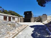
The Albany Forts are located on Mt Adelaide, overlooking King George Sound and the entrance to the Princess Royal Harbour. The site is comprised of two strategically placed guns, an underground magazine, numerous transported buildings, ruins, a few substantially reconstructed buildings, including the Albany Barracks, and a parade ground. Designed mainly in Victorian Georgian style, the majority of the buildings are rectangular in plan and symmetrical in form. The Military Institute, Guard House, Barracks and Repository Store (now serving as a Warden’s residence) share a formal relationship with each other and are focused around the Parade Ground, which is now a bitumen car park. From the entrance at a lower level, the access road passes the Parade Ground and main buildings before reaching the guns at the summit of Mount Adelaide. Although the current guns are not original, the two main gun emplacements, comprised of concrete and granite embattlements, are largely intact. Near the main entrance is the Repository Store, which has been largely reconstructed and now serves as the Warden’s residence. It is a simple shed-like structure with painted corrugated zincalume walls fixed horizontally and a replacement corrugated zincalume roof. A little further along is a building that was transported from elsewhere in the 1980s and now serves as a Visitor’s Education Centre. The structure is a corrugated zincalume Nissen hut, complete with an access ramp. The Guard House, set a little ways down the road, is a simple rectangular weatherboard hut that has a replacement corrugated zincalume gable roof and a porch facing the parade ground. The building consists of two rooms and one office. It has recently been replaced in its original location after it was removed and used for some time as a shed by a local farmer. A new brick fireplace and chimney have replaced the originals. The Military Institute is built of granite walls, brick quoins and a newly reconstructed corrugated zincalume roof. It is symmetrically laid out with a central entrance that originally opened onto a canteen. Beyond the entrance is another room of equal size that was originally used as a Sergeant’s Mess. Having been substantially reconstructed, the Sergeant’s Mess now houses a kitchen for the adjacent tearoom, situated in the former enlisting, lecture and recreation room. On the opposite side of the building, a room of equal size was used for the same purpose, but has now been converted into the Australian Light Horse Museum. Nearby is a corrugated iron Water Tank, which appears to date back to the completion of Albany Forts in 1893. Concrete footings have recently been inserted beneath the original timber columns, but the remainder of the structure is largely intact. Further along the main road are the Barracks, which have been largely reconstructed. The original Barracks appear to have been comprised of two long parallel buildings, with a common wall between and verandas spanning the long sides. The original buildings were constructed of timber on stone footings. To one side are the remains of extensions; floor joists laid directly on stone footings with a rubble binding in the joists. Adjacent to that are the remains of an ablution block. The internal timber framed walls and ceilings have been lined with pine boarding, but were probably originally lined with plaster on lathing. The remains of the World War II Ablution Block are nothing more than a concrete slab and a central low concrete wall, against which a urinal most likely stood. Across from the Barracks is the Parade Ground, which has been converted into a bitumen car park, but was probably originally pea gravel. The Quartermasters Store, which now serves as the Military Heritage Centre, consists of one large room with a double door at one end. The timber framed building appears to date from the time of the Second World War, but the roof and walls have been recently reclad with zincalume sheeting and the original steps have been replaced with an access ramp. Set a short distance away is the Commanding Officer’s Residence, which now houses a restaurant. In order to accommodate its new function, the building has been substantially renovated, including reroofing, the creation of larger openings between rooms and the insertion of a larger, modern kitchen. A gabled pavilion has been constructed adjoining the front veranda. A modern skillion roofed replica of the original 1893 weatherboard stables has been built upon the original stables site. Only the adjacent concrete manure pit is original. The former Married Quarters have been substantially reconstructed with new brickwork, stonework and flooring as well as the partial replacement of roof timbers and the complete replacement of the roof and roof 4 20040922 Assessment Princess Royal Battery Final ALB35 plumbing. These semi-detached brick and stone cottages have also been fitted with new windows and doors. The Padre White National Memorial Centre is formed of a re-located Nissen hut with an access ramp. The Warrant Officers House is nothing more than ruins comprised of two chimneys, three fireplaces and a corner wall. The Artificers Hut dated from World War II, but it has been relocated in Albany and only the concrete foundation remains. The Underground Magazine, a brick and concrete tunnel that runs through a granite outcrop near the summit of Mount Adelaide, is comprised of Jarrah flooring, combined with what appears to be graphite and includes recessed walls to provide storage for explosives and lights, with shelves for ammunition. Ventilation is provided by holes in the roof. The original guns were replaced in the 1930s and are housed in two gun emplacements. Although the guns themselves are not original, having come from Leighton Beach, the concrete and granite embattlements are largely original. Two metre by one metre slits provide access between guns as well as to the underground magazine. The site also includes several significant monuments and exhibits.
Built in 1893, the Albany Forts, formerly known as the Princess Royal Battery and Barracks, has had a rich and varied history. Built as a strategic defence for Western Australia, and the then Australasian Colonies, the Albany Forts were placed on Mt. Adelaide in order to provide maximum coverage of King George Sound. Albany Forts originally housed a garrison of 26 men and was later home to the U.S.A.’s ‘Great White Fleet’ in 1908. During World War I, the Forts played a very important role as the last port of departure for Australian and New Zealand troops. Although abandoned for a short time in the 1920s, the Forts reclaimed its importance in 1925 when it housed the nationally acclaimed 24th Heavy Battery Defence Unit, under the command of Lieutenant E.N. Knight. Later, during World War II, two American submarines were based in King George Sound and covered by the Albany Forts guns . After World War II, the Albany Forts fell into disrepair and were eventually sold to a private businessman whose intention was to convert the site into a holiday resort. These plans never materialized and the land was resumed by the Public Works Department in 1977. Not long after that, the land was vested in the Town of Albany as Reserve 38226 for the purpose “Parklands and Recreation.” Following further renovations in 1986, the place was opened to the public in 1988 and the land was officially declared a military heritage park in 1995. It has continued to serve this role since.
The place was originally constructed as a military base and now functions as a military park, giving it moderate integrity. It has moderate authenticity, as some buildings have been reconstructed, but this has been sympathetic to the overall original building fabric with a generally consistent attempt to match the original materials.
The condition of the buildings varies, but due to recent conservation efforts and the establishment of the Princess Royal Fortress Military Heritage Park, the overall condition of the place is good.
| Name | Type | Year From | Year To |
|---|---|---|---|
| Major Rainsford-Hannay | Architect | 1891 | - |
| Reserve | Lot/Location | Plan/Diagram | Vol/Folio |
|---|---|---|---|
| 1347, 1377 | LR3009, 746 |
This information is provided voluntarily as a public service. The information provided is made available in good faith and is derived from sources believed to be reliable and accurate. However, the information is provided solely on the basis that readers will be responsible for making their own assessment of the matters discussed herein and are advised to verify all relevant representations, statements and information.
Constructed from 1939, Constructed from 1893
03255 Heritage Park
Albany Forts, a renovated artillery battery and army barracks, consisting of two guns, an underground magazine, numerous transported buildings, ruins, a few substantially reconstructed buildings and a parade ground, has cultural heritage significance for the following reasons: The place formed part of the strategic defence of Australia from colonial times, being an early example of Federal co-operation of the states, and through two world wars. The place was the principal rendezvous for Australian and New Zealand troops departing on overseas service during World War One. The place is now a unique military heritage park at a national level. The place has landmark quality, being situated on Irrerup/Mt Adelaide, one of the group of significant granite mounts that are strongly identified with the geography and aesthetics of the Albany townsite and to the Menang Noongar creation stories. The place is highly valued by the community both for its historic heritage and the cultural landscape.
Albany Forts is situated on the summit and west of the summit of Irrerup/Mt Adelaide, south west of the southern part of Binalup/Middleton Beach. Albany Forts, a renovated artillery battery and army barracks, consisting of two guns, an underground magazine, numerous transported buildings, ruins, a few substantially reconstructed buildings and a parade ground. It was the principal rendezvous for Australian and New Zealand troops departing on overseas service during World War One. Albany Forts include many uncommon structures such as the Guns, Water Tank and reconstructed buildings. The Military Institute, Guard House, Barracks and Repository Store bear a formal relationship to each other focussing on the parade ground, whereas the siting of the other buildings appears to be influenced by the topography of the site. The former buildings are designed in the Victorian Georgian Style and are rectangular in plan and symmetrical in form. The individual buildings have been constructed from a variety of materials at different times but are essentially simple designs and which have been adapted for different uses since the Forts closed as a defence base. Other buildings, such as the corrugated zincalume Nissen huts, were transported to the site in the 1980’s and used for a variety of purposes. The Guard House is a simple rectangular weatherboard hut with a corrugated zincalume roof. It was removed from the site and used as a shed by a local farmer but was returned and reused by the Forts volunteers. One of the most substantial buildings is the Military Institute. It is constructed from granite walls with brick quoins and a corrugated zincalume roof. It has been substantially reconstructed and has been used for a variety of purposes (including a museum, café, gift shop, offices). Only a concrete slab and a low concrete wall remain of the World War Two ablution block. However, the Water Tank is little altered from the 1893 construction. Concrete footings have been inserted under the original timber columns. The Barracks have been largely reconstructed, the internal timber framed walls and ceilings have been lined with pine whereas the original material was probably lath and plaster. Remains of extensions can still be seen to one side of the building, as are the remains of an ablution block. The parade ground is a bituminised car park; the original material was probably pea gravel. The Quartermaster’s Store built during World War Two is timber framed with corrugated zincalume cladding on the walls and roof. The former Commanding Officer’s Residence has undergone major renovations including re-roofing, enlarging of openings between rooms and the insertion of a modern kitchen to facilitate its use as a restaurant (Carlysles). A replica of the original Stables has been built of weatherboard on the same site as the 1893 original. The adjacent concrete manure pit is original. The brick and stone semidetached married quarters have been substantially reconstructed, with new brickwork, stonework, flooring, the partial replacement of roof timbers, new doors and windows, and a completely new roof. Only ruins remain of the Warrant Officers House and a concrete pad is the only remnant of the Artificer’s Hut. The Underground Magazine consists of a brick and concrete tunnel through a granite outcrop near the summit of Mount Adelaide. The floor is of jarrah blocks and graphite; the walls are recessed for the storage of explosives and ammunition. There are holes for ventilation in the walls. |The two guns on the site have been relocated from Leighton Beach however the concrete and granite embattlements are largely original. Linking the guns and the magazine are access slits approximately two metres high by one metre wide.
In the 1880’s, the threat of Russian Expansionism was one of the stated reasons for increasing the security of the Australian colonies. The strategic location of King George Sound prompted the Federal Council of Australasia to provide three six-inch batteries and machine guns. The colonies jointly funded the building of a garrison. The Imperial Government supplied the equipment for construction and John Blackburn of the Victorian Public Works supervised construction. The battery was completed in February 1892 and the garrison in 1893. South Australian troops under the command of Captain J.C. Hanker comprised the first garrison at Albany Forts. Following Federation in 1901, Albany Forts was taken over by the Australian Garrison Artillery. During World War One, Albany Forts served as the principal rendezvous for Australian and New Zealand troops before embarking on overseas service. Following World War One, Albany Forts was abandoned then reformed in 1925 and staffed by the 24th Battery Australian Garrison Artillery. Modernisation was undertaken prior to World War Two and during the war years a command post and naval signal lookout were added. Two American submarines were based in King George Sound during the war years. In the post war period, Albany Forts were officially decommissioned and closed in 1956. The guns were dismounted and buried. In 1959 the Albany Forts passed into private ownership and were used as a school and holiday units. The venture did not last long, the buildings fell into disrepair and were subsequently vandalised. The site was declared a recreation reserve in 1977 and in 1983 was vested in the Town of Albany. Conservation, renovation and development of the site began in 1987 culminating in the official opening in November 1988, in conjunction with Australia’s bicentennial celebrations. In 1995, Albany Forts became a military heritage park and remains a popular tourist attraction. In 2014, the National Anzac Centre (NAC) was officially opened – built on the grassed area south of the parade ground - to coincide with the centenary of Anzac Day and of the role of Albany in World War One as the main point of departure for the troops from the eastern colonies. The former Repository Store was added to and adapted to become the Garrison café and the nearby Nissen Hut was relocated within the Forts. Convey walk was established along the road leading up to the flagpole and a new lookout at the top of Mt Adelaide was built. The Military Institute was converted from being the café to a gift shop and administration offices. There are also walks around the Forts that include the original battery sites on Mt Adelaide such as the Plantagenet Battery.
Integrity: Moderate Authenticity: High/Moderate
Fair
| Ref ID No | Ref Name | Ref Source | Ref Date |
|---|---|---|---|
| Heritage TODAY Site visit and Assessment | 1999 | ||
| Heritage Council of Western Australia assessment for entry on interim basis | 1996 |
| Owner | Category |
|---|---|
| City of Albany | Local Gov't |
This information is provided voluntarily as a public service. The information provided is made available in good faith and is derived from sources believed to be reliable and accurate. However, the information is provided solely on the basis that readers will be responsible for making their own assessment of the matters discussed herein and are advised to verify all relevant representations, statements and information.
Horrocks Rd Northampton
approx 4 kms W of Northampton
Northampton
Midwest
Constructed from 1954
| Type | Status | Date | Documents |
|---|---|---|---|
| Heritage List | Adopted | 15 May 2020 | |
| State Register | Registered | 02 Jun 1998 | HCWebsite.Listing+ListingDocument, HCWebsite.Listing+ListingDocument |
| Type | Status | Date | Documents |
|---|---|---|---|
| (no listings) |
| Type | Status | Date | Grading/Management | |
|---|---|---|---|---|
| Category | ||||
| Municipal Inventory | Adopted | 19 Apr 1996 | Category 1A | |
| Library Id | Title | Medium | Year Of Publication |
|---|---|---|---|
| 5778 | Former State Battery, Northampton, Western Australia : conservation plan. | Heritage Study {Cons'n Plan} | 2002 |
| 5777 | Aboriginal heritage : a desktop survey of the Aboriginal heritage values of the Northampton State Battery, Northampton, Western Australia. | Report | 2002 |
| 9444 | Interpretation strategy for Northampton State Battery. | Heritage Study {Other} | 2005 |
Individual Building or Group
| Epoch | General | Specific |
|---|---|---|
| Present Use | VACANT\UNUSED | Vacant\Unused |
| Original Use | MINING | Mining Battery |
| Style |
|---|
| Other Style |
| Type | General | Specific |
|---|---|---|
| Roof | METAL | Corrugated Iron |
| Wall | ASBESTOS | Fibrous Cement, flat |
| Wall | METAL | Corrugated Iron |
| General | Specific |
|---|---|
| OCCUPATIONS | Mining {incl. mineral processing} |
| OUTSIDE INFLUENCES | Markets |
This information is provided voluntarily as a public service. The information provided is made available in good faith and is derived from sources believed to be reliable and accurate. However, the information is provided solely on the basis that readers will be responsible for making their own assessment of the matters discussed herein and are advised to verify all relevant representations, statements and information.
Constructed from 1953
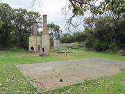
1993 The site has very high local and high State significance for historic, social, and scientific reasons. 2004 Northampton State Battery, a lead battery complex consisting of crushing mill, offices, workshop, managers house, weighbridge and a large [gravity] dam has cultural heritage significance for the following reasons: •The place is the only surviving gravity separation plant for the treatment of heavy minerals in the Western Australian State Battery complex. •The place is directly related to the third phase of mining activity (1948-1981) in the Northampton [Murchison] mineral fields. •The place is valued by the local community and contributes to its sense of place. •The group of structures and machinery are dominant features in [over the natural] their modified environment.
1993 The State lead battery site still contains significant structures and machinery indicative of its former operation although some material has been removed. It is a good example of industrial architecture and the importance of the site is acknowledged with the Wheal Ellen mine site (Site 117) as a precinct in the Northampton Town Planning Policies which suggests tourism potential for the site. See also similar comments for Wheal Fortune (Site No.35) and Baddera (Site No.37) mines. 2004 For a full description see Eastman and Poletti etal. The structure of the building housing the Battery remains relatively intact although the external cladding fabric is in poor condition. Much of the Battery plant is however missing, having been sold off and removed upon closure of the site. The Battery is now in need of some urgent repair work, particularly in the weatherproofing of the building and the stabilisation of adjacent ground, to ensure that it does not suffer further deterioration, which may seriously undermine its condition. The fabric of the Managers Residence and office is in poor condition, but does not contribute to the cultural significance of the site and would not warrant substantial repair works. At the time of the 2004 Ml review a section of the rear gantry had been deliberately collapsed by the (presumably illegal) removal of vertical pipework (State Battery 1 to 2). The tailings dump area remains relatively unstable and unvegetated, and the issue of lead contamination of the Nokanena Brook continues to be of environmental concern for the community and the Department of Environmental Protection. At the time of the 2004 Ml review there was no evident progress in rehabilitation of the tailings area.
1993 Construction of the Lead Battery commenced in 1953 and was operational by 1954 continuing through into the midlate 60's; though less than 50 years old it was, nonetheless, an important part of the mining industry for the time. Its construction was in response to the jump in the world price of lead in the mid 1940's which caused a post war revival in the Western Australian mining industry. 2004 The structure of the building housing the Battery remains relatively intact although the external cladding fabric is in poor condition. Much of the Battery plant is however missing, having been sold off and removed upon closure of the site. The Battery is now in need of some urgent repair work, particularly in the weatherproofing of the building and the stabilisation of adjacent ground, to ensure that it does not suffer further deterioration, which may seriously undermine its condition. The fabric of the Managers Residence and office is in poor condition, but does not contribute to the cultural significance of the site and would not warrant substantial repair works. The tailings dump area remains relatively unstable and unvegetated, and the issue of lead contamination of the Nokanena Brook continues to be of environmental concern for the community and the Department of Environmental Protection. Planning by the Department of Mines, for the Former State Battery at Northampton, had commenced even before 1949 when the site was surveyed. Construction, coordinated by the Department, commenced in 1952 and the Battery was officially opened in 1954. The Battery was built on mineral lease land surrendered to the Department in 1952. This original reservation has been extended on a number of occasions to form the site currently vested in the Minister. The Battery was inactive from 1 April 1983. The Shire of Northampton expressed interest in taking the place over for tourism, and the Superintendent of State Batteries recommended this strategy to the Director General of Mines. However, the proposal was rejected for reasons of insurance and a desire to keep the Battery in working order. The plant was put on a care and maintenance from November 1984. In June 1989, the Western Australian Mint announced that the mill and fittings, house and ancillary buildings at the Battery had been sold at public tender to Plantagenet Securities Pty Ltd. In the succeeding years, most of the plant was sold off piecemeal by the company. The Battery, its site and the associated building infrastructure are now the property of the Western Australian State Government through the Western Australian Mint. The Battery and buildings are unused and derelict, and the site secured and signposted with warnings as to the dangerous nature of the lead tailings at the site.
Integrity: Low
Poor
| Ref ID No | Ref Name | Ref Source | Ref Date |
|---|---|---|---|
| Eastman and Poletti Pty and Gerard MacGill and Associates; "Former State Battery, Northampton, Western Australia, Conservation Plan". | Department of Housing and Works, WA. | 2002 |
| Owner | Category |
|---|---|
| West Australian Mint | State Gov't |
This information is provided voluntarily as a public service. The information provided is made available in good faith and is derived from sources believed to be reliable and accurate. However, the information is provided solely on the basis that readers will be responsible for making their own assessment of the matters discussed herein and are advised to verify all relevant representations, statements and information.
End of Point Peron Rd, Cape Peron Rockingham
Cape Peron Battery Complex
Point Peron "K" Battery
Rockingham
Metropolitan
Constructed from 1942 to 1945
| Type | Status | Date | Documents |
|---|---|---|---|
| Heritage List | Adopted | 24 Oct 1995 | |
| State Register | Registered | 13 Oct 2019 | HCWebsite.Listing+ListingDocument, HCWebsite.Listing+ListingDocument |
| Type | Status | Date | Documents |
|---|---|---|---|
| (no listings) |
| Type | Status | Date | Grading/Management | |
|---|---|---|---|---|
| Category | ||||
| Municipal Inventory | Adopted | 24 Apr 2018 | Category A | |
| Register of the National Estate | Permanent | 30 May 1995 | ||
24003 Cape Peron K Battery and Barracks Group
The site of Cape Peron K Battery Complex has been associated with the defence of Australia since its acquisition by the Commonwealth in 1916. The place demonstrates technical achievement through its use of ‘Panama Mounts’, a versatile design that had the potential to achieve a 360° traverse to increase the capacity of its 155mm guns and has potential for interpreting the extensive coastal defence system of Western Australia during World War II.
Cape Peron K Battery Complex comprises Gun Emplacements North and South and their associated and adjacent Ready Ammunition and Storage Bunkers, a Battery Observation Post, an Operations Centre, archaeological deposits in and around the structures, and other structures associated with the Battery.
The sinking of HMAS Sydney, and the entry of Japan into the war on 7 December 1941, changed the strategic picture in the Indian Ocean and Pacific Ocean theatres. Singapore fell on 15 February 1942, Darwin was bombed on 19 February by the same Japanese fleet that had attacked Pearl Harbour, and on 3 March, Broome was attacked from the air. The sudden conquest of Hong Kong, Singapore, the Dutch East Indies and the Philippines left Australia as the most suitable base for the development of an Allied counter offensive. It was realised that Japanese submarines and surface vessels would be active, and that there was a need to supplement Australia’s coastal defences. General MacArthur arrived in Darwin on 17 March 1942 and was invited to assume the role of Supreme Commander of the Allied Forces in the Southwest Pacific Area. On 18 April, MacArthur assumed command over all Australian Forces. McArthur subsequently requested an inspection of facilities to ensure that the US Troops stationed in Australia would be properly protected and this led to the establishment of the Letter Batteries. In December 1942, the ‘K’ Battery personnel arrived in Fremantle without guns or searchlights. To control the coast defences of Cockburn Sound, HQ Southern Fire Command was formed in January 1943. Peron Battery was to be situated on the western end of Cape Peron with its Battery Observation Post (BOP) on the 30 metre feature some 300 to 400 metres to the south of the gun emplacements. The Operations Centre (Plotting Room) was located, among a thicket of scrub, behind the guns and northeast of the BOP. The battery was served by two 90cm searchlights located at John Point and Mushroom Rocks, not the 150cm searchlights usually associated with such batteries. The reduced threat to Western Australia finally led to further rationalisation in the second half on 1944. The 155mm guns on Cape Peron were withdrawn in December with the men assigned to developing CA/AA batteries. In early 1945, personnel were reallocated to anti-aircraft units in the Fremantle area and ‘K’ Australian Heavy Battery disbanded.
Gun Emplacement No 1 is almost completely covered by sand and vegetation. Gun Emplacement No 2 has suffered major structural damage due to erosion undermining its base. The Observation Post (OP) located on the highest point of Cape Peron, has for many years been a prominent vantage point. Continued pedestrian activity around the OP has, coupled with wind erosion, contributed to a serious undermining of the base of its foundation. Vandals have also defaced walls inside and outside the building.
| Library Id | Title | Medium | Year Of Publication |
|---|---|---|---|
| 11442 | Point Peron 'K' Battery | Heritage Study {Cons'n Plan} | 2016 |
Individual Building or Group
| Epoch | General | Specific |
|---|---|---|
| Original Use | MILITARY | Fort or Gun Emplacement |
| Present Use | SOCIAL\RECREATIONAL | Other |
| Type | General | Specific |
|---|---|---|
| Wall | BRICK | Common Brick |
| Other | BRICK | Common Brick |
| Wall | CONCRETE | Reinforced Concrete |
| Wall | CONCRETE | Reinforced Concrete |
| Other | CONCRETE | Reinforced Concrete |
| Roof | BRICK | Common Brick |
| General | Specific |
|---|---|
| OUTSIDE INFLUENCES | World Wars & other wars |
| OUTSIDE INFLUENCES | Tourism |
This information is provided voluntarily as a public service. The information provided is made available in good faith and is derived from sources believed to be reliable and accurate. However, the information is provided solely on the basis that readers will be responsible for making their own assessment of the matters discussed herein and are advised to verify all relevant representations, statements and information.
Constructed from 1943 to 1945
Point Peron “K” Battery is a large, public open space of sand dune formation covered with dense native planting which features structures constructed in 1943 including two gun emplacements, observation post bunker, operations bunker, two ammunition bunkers and several other ancillary elements which together were part of a network of defence strategies around the port of Fremantle. The place has cultural heritage significance for the following reasons; • the place, together with the other elements of Western Australia’s coastal defence system, known as ‘Fremantle Fortress’ erected in response to external threats during WWII and together have the potential to yield information about coastal defence strategies; • the Battery demonstrates technical achievement in its design – the guns were placed to enable them to cover any shipping approaching within range south of Rockingham and Safety Bay and the western approaches to Garden Island, as well as providing cover for the boom defence which was laid across South Channel; • the remaining built elements of Point Peron “K” Battery are representative of WWII coastal defence architecture, of functional design and simplistic but robust construction used by the military engineers in a remote sand dune environment; • the site of the former Point Peron campsite and the headland is valued by the wider community as the venue for many school camps since 1946 to 1996; • Point Peron “K” Battery is associated with members of the Australian Army specifically the Artillery who served at this site or similar batteries. It is also valued by members of this cohort for its demonstration of past techniques and practices; • the place is valued as an informal recreational space both before and after WWII and as part of the Rockingham Lakes National Park; and, • Point Peron “K” Battery is valued by the local community, members of Parliament and the Army Reserves who are contributing to the restoration and conservation of the place. • the pathways, carparks and remnant signage have no cultural heritage significance.
Point Peron remains as a predominantly natural environment with only the remnant WW2 infrastructure placed at strategic points around the site. Pathways link the majority of the elements although some are not readily accessible largely due to safety concerns. The visible and accessible elements of the extant infrastructure are: • Observation Post • Operations Bunker • Gun Emplacement 1 (south) and associated ammunition bunker • Gun Emplacement 2 (north) and associated ammunition bunker • Concrete water tank (possibly from the former Barracks or later use of the same buildings) • Remnant well; and • Debris from the removed Barracks These structures are in varying condition with the remnant well and the concrete water tank in the most fragile condition. The southern gun emplacement is in poor condition, effectively falling off the side of the hill where sand movement has caused the structure to become unstable. The former gun emplacements, observation post and observation bunker are of reinforced concrete construction of a simple design. The function of these structures required a sturdy and basic structure. All accessible structures were showing varying degrees of concrete cancer with evidence of spalling and rusted reinforcements. The structures have also been subject to vandalism, predominantly in the form of graffiti which has necessitated the painting of the visible exteriors, the structures are now green rather than natural brick and concrete. Except for the Observation Tower, the bunkers and gun emplacements have become partially submerged due to encroaching vegetation and changing sand levels. The bunkers get cleaned out but despite sandbags, they soon fill up again. The remains of other structures and buidings associated with the battery on the headland include searchlights at John Point and Mushroom Rocks. Due to the continual vandalism, the entrances to the bunkers have been locked with gates to prevent unauthorised access.
The Cape Peron headland has undergone minimal development and the main features on the site are remnants of the World War II battery and associated structures constructed in 1943 as part of the defence system for the port of Fremantle. Prior to this period of occupation by the Australian Army the headland had been the home for fisherman and a destination for tourists. After the dismantling and removal of the guns from the site in 1944 the site remained the domain of the Australian Army until a long term lease with the National Fitness Council. This organisation used the former barracks constructed on the northern side of the headland as a holiday and recreation camp for young people. The campsite was subsequently used as a holiday camp until the late 1990s by government and private organisations as well as individual family groups. The campsite buildings were demolished c1997. Since that time the site has been accessed for informal recreation with the provision of paths and parking enabling visitors to access the site without damaging the landscape. The native vegetation had degraded throughout the 20th century and regeneration programs in the late 20th century have helped to stabilise the landscape. In recent years, there has been a resurgence of interest in the battery structures and their role in the defence of Australia during World War II. Local community groups, army reservists and members of the military have contributed many hours of voluntary labour to clear the structures of sand and painting over of graffiti on the structures.
Integrity: Moderate Degree Authenticity: Moderate Degree
Fair
| Ref ID No | Ref Name | Ref Source | Ref Date |
|---|---|---|---|
| Point Peron 'K' Battery Cons MgtPlan | |||
| City of Rockingham Municipal Heritage Investory | |||
| Aerial Photos | Landgate |
| Reserve | Lot/Location | Plan/Diagram | Vol/Folio |
|---|---|---|---|
| 48968 | 301 | 48616 |
| Owner | Category |
|---|---|
| Department of Environment & Conservation | State Gov't |
This information is provided voluntarily as a public service. The information provided is made available in good faith and is derived from sources believed to be reliable and accurate. However, the information is provided solely on the basis that readers will be responsible for making their own assessment of the matters discussed herein and are advised to verify all relevant representations, statements and information.
Rottnest Island
Rottnest
Rottnest
| Type | Status | Date | Documents |
|---|---|---|---|
| (no listings) |
| Type | Status | Date | Documents |
|---|---|---|---|
| (no listings) |
| Type | Status | Date | Grading/Management | |
|---|---|---|---|---|
| Category | ||||
| (no listings) | ||||
00525 Kingstown Barracks
Individual Building or Group
| Epoch | General | Specific |
|---|---|---|
| Original Use | MILITARY | Fort or Gun Emplacement |
| Present Use | MILITARY | Fort or Gun Emplacement |
This information is provided voluntarily as a public service. The information provided is made available in good faith and is derived from sources believed to be reliable and accurate. However, the information is provided solely on the basis that readers will be responsible for making their own assessment of the matters discussed herein and are advised to verify all relevant representations, statements and information.
Oliver Hill Rottnest Island
Signal Station & Battery Observation Post
World War II Buildings, Oliver Hilll Battery and Signal Ridge, Wadjemup/Rottnest
Rottnest
Rottnest
Constructed from 1936
| Type | Status | Date | Documents |
|---|---|---|---|
| State Register | Registered | 14 Jun 2021 | HCWebsite.Listing+ListingDocument, HCWebsite.Listing+ListingDocument |
| Type | Status | Date | Documents |
|---|---|---|---|
| RHP - Land Amendment - Stakeholder Consultation | Current | 05 Aug 2022 | HCWebsite.Listing+ListingDocument |
| Type | Status | Date | Grading/Management | |
|---|---|---|---|---|
| Category | ||||
| Register of the National Estate | Permanent | 28 Sep 1982 | ||
| Classified by the National Trust | Classified | 08 Feb 1980 | ||
| Aboriginal Heritage Sites Register | Recorded | |||
03650 Wadjemup/Rottnest Island
| Library Id | Title | Medium | Year Of Publication |
|---|---|---|---|
| 11573 | H1 Gun, Oliver Hill, Rottnest Island | Conservation works report | 1998 |
| 9435 | Oliver's Hill Battery. Ammunition hoist research. | Heritage Study {Other} | 1987 |
| 7653 | Oliver Hill battery Rottnest Island conservation plan. | Heritage Study {Cons'n Plan} | 2005 |
| 1036 | Oliver Hill Battery : conservation assessment. | Heritage Study {Other} | 1995 |
Historic site
| Epoch | General | Specific |
|---|---|---|
| Original Use | MILITARY | Fort or Gun Emplacement |
| Present Use | MILITARY | Fort or Gun Emplacement |
| General | Specific |
|---|---|
| OUTSIDE INFLUENCES | World Wars & other wars |
This information is provided voluntarily as a public service. The information provided is made available in good faith and is derived from sources believed to be reliable and accurate. However, the information is provided solely on the basis that readers will be responsible for making their own assessment of the matters discussed herein and are advised to verify all relevant representations, statements and information.
In 1935 as part of an overall plan to extend and modernise the coast artillery defences for defended parts throughout Australia, preliminary work for the installation of heavy guns on Rottnest Island was commenced partly as a result of the British Governments decision to fortify Singapore. Progress was slow probably through indecision as to whether the development of air power should be given a higher priority. The original conception included standard 3 gun mounting and further delays occurred when the British Government could not release the third gun – resulting in plans being modified as a two gun battery. As such it is believed that this battery is the only one left in the Commonwealth with its guns still mounted. The natural constraints of building an installation of this magnitude involving the transport of most materials and fittings by barge and railway track from the mainland are formidable. The effectiveness of construction techniques are reflected in the soundness and freedom from damage, amongst other menaces, through water penetration of the underground installation. The complex demonstrates the end of an era of coastal defences which was primarily intended to protect the important port installations and its ships from enemy vessels, and to deter attemps to seize the port as part of an invasion plan. At the time they were installed these 9.2 inch counter bombardment coastal defence guns were the most modern in any coastal fortress. Whilst the battery was intentionally located to suit the function of the battery, present proposed future development as a museum can be seen as contribution to the enhancement of this spectacular site from many aspects. From information available it appears that this battery contains the last 9.2 inch coast defence guns mounted in situ in the British Commonwealth and as such are worthy of preservation as an historic example of a 20th century coast defence battery.
Description RAILWAY. 3ft 6 inch gauge tracks of light rails spiked to jarrah sleepers including 15 manually operated turnouts. (10,000 sleepers and 10 tons of spikes used). Embankments and sand hill cuttings replanted and camouflaged and have withstood the ravages of erosive action. Much of the railway equipment was second hand rolling stock and rails recovered from the abandoned Naval Base site at Coogee. Parts of the track are still visible in the reserve and the remainder is possibly concealed under filling marl. Tracks last used 1960. The Rottnest Island Board would like to restore the track but the cost of ballasting presently prevents further consideration. TUNNEL COMPLEX The concrete gun emplacements, underground magazines, engine rooms, fortress and battery plotting rooms, concrete observation posts were constructed by civilian contractors under the supervision of the Commonwealth department of the Interior. The underground facilities constructed from reinforced concrete in an excavation most likely later backfilled, include a powerhouse which contained two 180HP Ruston Hornsby Diesel Engines (one hopefully to be replaced soon) coupled to two 120 KVA electric generators, fortress and battery fire control rooms, hydraulic pump chambers, cordite and shell magazines, first aid casualty bays and air compressors, all interconnected with underground tunnels. All underground plant and equipment has unfortunately been removed, including a sophisticated communications system, most furniture, rifle racks, storage racks, shelving etc. Restoration work by the Rottnest Island Board is in progress. GUNS: It is believed that one of the 9.2 inch gun barrels was held in reserve by the Royal Navy in Hong Kong until taken over by the British Army in 1910. The other barrel is believed to have been part of the shore battery at Portland, Dorset, U.K. iin 1919. Both barrels were re-tubed and modified at the Royal Gun Factory in 1935 – 36. The letters E.O. C. 1901 stamped on the breech refer to the original barrels having been manufactured by the Elswick Ordinance Company (later Vickers) in 1901. 9.2 inch guns MK 10 on MK 7 mounting total barrel length 11.2 metres revolving weight approx.. 140 tons (142.2 tonne) Maximum range 33.5 km depending on charge etc. BATTERY COMMAND POST Three storey brick building contained range finding and fire control instruments to pass fire direction and control information to the battery or fortress plotting rooms or direct to the guns or any other battery through a complex communications system within the Fremantle fortress system.
Assessment 1982 Defence Installation, Installed 1936, all working equipment removed 1963 Includes: all construction on Commonwealth land; reserve on both surface and underground including railway installations, tunnel complex and gun mountings and at Signal Ridge near the main light house - 3 storey brick battery command post building
This information is provided voluntarily as a public service. The information provided is made available in good faith and is derived from sources believed to be reliable and accurate. However, the information is provided solely on the basis that readers will be responsible for making their own assessment of the matters discussed herein and are advised to verify all relevant representations, statements and information.
6km south-east of Sandstone on the Menzies-Sandstone Rd Sandstone
6km south-east of Sandstone on the Menzies-Sandstone Road, Sandstone
Sandstone
Midwest
Constructed from 1925, Constructed from 1904
| Type | Status | Date | Documents |
|---|---|---|---|
| State Register | Registered | 07 Sep 2006 | HCWebsite.Listing+ListingDocument, HCWebsite.Listing+ListingDocument |
| Type | Status | Date | Documents |
|---|---|---|---|
| (no listings) |
| Type | Status | Date | Grading/Management | |
|---|---|---|---|---|
| Category | ||||
| Municipal Inventory | Adopted | 25 Jun 1997 | Category 1 | |
State Battery (fmr), Sandstone is in fair to poor condition. Portions of the Battery are unsafe as structural members require repair and/or refixing. The place is being preserved by the Shire of Sandstone, as the Shire recognises its heritage value and the social significance of the place to the community.
| Library Id | Title | Medium | Year Of Publication |
|---|---|---|---|
| 6724 | Conservation plan for Sandstone State Battery (fmr) (1908), Sandstone, Western Australia. | Heritage Study {Cons'n Plan} | 2003 |
Individual Building or Group
| Epoch | General | Specific |
|---|---|---|
| Present Use | VACANT\UNUSED | Vacant\Unused |
| Original Use | MINING | Mining Battery |
| Style |
|---|
| Vernacular |
| Type | General | Specific |
|---|---|---|
| Wall | METAL | Corrugated Iron |
| Roof | METAL | Corrugated Iron |
| General | Specific |
|---|---|
| OCCUPATIONS | Mining {incl. mineral processing} |
| DEMOGRAPHIC SETTLEMENT & MOBILITY | Resource exploitation & depletion |
This information is provided voluntarily as a public service. The information provided is made available in good faith and is derived from sources believed to be reliable and accurate. However, the information is provided solely on the basis that readers will be responsible for making their own assessment of the matters discussed herein and are advised to verify all relevant representations, statements and information.
Constructed from 1904, Constructed from 1925
The former State Battery has high historic significance for its essential role in the mining industry in the Sandstone district. The place has further significance given that much of the machinery is still intact.
A large timber framed structure which is clad with corrugated iron. It contains a five head stamper, a diesel engine with a large generator, a cooling system attached to the southern facade and other machinery inside. There is evidence of white ant damage. There is a wire fence running around the perimeter of the Battery.
A State Battery was established at Sandstone by removing one which had fallen into disuse at Paynesville, about 80km west of Sandstone. Andrew Irvine was appointed the first manager of the Battery and was responsible for its dismantling and removal to the new site, which was a small distance west of the present location. Teams of horses, donkeys and bullocks were used to transport the Battery in early 1904. Irvine collapsed and died on April 10, just prior to its completion. The Battery was moved to its present site in 1925. Initially it was operated by coking local wood, but was later converted to diesel power. During its working life a total of 135, 809 tons of ore were treated here, producing 115, 787 ounces of bullion. The Battery closed in 1982.
Integrity: High Degree
Fair
| Ref ID No | Ref Name | Ref Source | Ref Date |
|---|---|---|---|
| "Sandstone Heritage Trail brochure". |
| Owner | Category |
|---|---|
| Department for Planning & Infrastructure | State Gov't |
This information is provided voluntarily as a public service. The information provided is made available in good faith and is derived from sources believed to be reliable and accurate. However, the information is provided solely on the basis that readers will be responsible for making their own assessment of the matters discussed herein and are advised to verify all relevant representations, statements and information.