Local Government
Gingin
Region
Avon Arc
Gingin
Gingin
Avon Arc
| Type | Status | Date | Documents |
|---|---|---|---|
| (no listings) |
| Type | Status | Date | Documents |
|---|---|---|---|
| (no listings) |
| Type | Status | Date | Grading/Management | |
|---|---|---|---|---|
| Category | ||||
| Register of the National Estate | Indicative Place | |||
Landscape
| Epoch | General | Specific |
|---|---|---|
| Original Use | PARK\RESERVE | Park\Reserve |
| General | Specific |
|---|---|
| OCCUPATIONS | Mining {incl. mineral processing} |
This information is provided voluntarily as a public service. The information provided is made available in good faith and is derived from sources believed to be reliable and accurate. However, the information is provided solely on the basis that readers will be responsible for making their own assessment of the matters discussed herein and are advised to verify all relevant representations, statements and information.
Gingin
Gingin
Avon Arc
Constructed from 1900
| Type | Status | Date | Documents |
|---|---|---|---|
| (no listings) |
| Type | Status | Date | Documents |
|---|---|---|---|
| (no listings) |
| Type | Status | Date | Grading/Management | |
|---|---|---|---|---|
| Category | ||||
| Municipal Inventory | Adopted | 18 Oct 2005 | Category D | |
Individual Building or Group
| Epoch | General | Specific |
|---|---|---|
| Original Use | RESIDENTIAL | Single storey residence |
| General | Specific |
|---|---|
| PEOPLE | Early settlers |
| DEMOGRAPHIC SETTLEMENT & MOBILITY | Settlements |
This information is provided voluntarily as a public service. The information provided is made available in good faith and is derived from sources believed to be reliable and accurate. However, the information is provided solely on the basis that readers will be responsible for making their own assessment of the matters discussed herein and are advised to verify all relevant representations, statements and information.
Constructed from 1900
The site of the home of the early settlers.
In 1866 Henry Jones, one of three sons of Richard "Bull" Jones, after whom Bullsbrook is named, married Mary Ann Gee of Woodloes near the Junction and founded Mount Hill on the Gingin Brook about three miles up from Woodloes. About 1900 a new house was built at Mount Hill. In 1922 Mount Hill was sold to the Troy family, who continued to farm it after Thomas Troy's death in 1937, aged 84 Mount Hill was sold to Ernest Lee Steere in 1960.
This information is provided voluntarily as a public service. The information provided is made available in good faith and is derived from sources believed to be reliable and accurate. However, the information is provided solely on the basis that readers will be responsible for making their own assessment of the matters discussed herein and are advised to verify all relevant representations, statements and information.
Gingin
Police Paddock
Gingin
Avon Arc
| Type | Status | Date | Documents |
|---|---|---|---|
| (no listings) |
| Type | Status | Date | Documents |
|---|---|---|---|
| (no listings) |
| Type | Status | Date | Grading/Management | |
|---|---|---|---|---|
| Category | ||||
| Municipal Inventory | Adopted | 18 Oct 2005 | Category D | |
Landscape
| Epoch | General | Specific |
|---|---|---|
| Other Use | RESIDENTIAL | Other |
| Present Use | RESIDENTIAL | Other |
| Original Use | GOVERNMENTAL | Other |
This information is provided voluntarily as a public service. The information provided is made available in good faith and is derived from sources believed to be reliable and accurate. However, the information is provided solely on the basis that readers will be responsible for making their own assessment of the matters discussed herein and are advised to verify all relevant representations, statements and information.
An important part of the early settlement in Gingin. Many styles of house construction are evident here.
An area of high land within a bow of the Gingin Brook. Originally, a semi-permanent camp of the Aborigines When Police were stationed here, a fence across the narrowest part of the land provided a safe place for horses, hence the alternative name The Police Paddock'.'The Horseshoe' refers to the general shape of the land. During the 1860's, the police had erected some 1552 chains of two rail Mahogany (Jarrah) fencing, Jarrah posts and Red Gum rails. This could be approximately where Daw St and Edgar St now lie. The Police Paddock was not included in the original Town site but a plan of suburban lots was published in 1899. The first were three or four-acre lots all with Brook frontage, and intended for orchard, vineyards or market gardens. The remainder of The Horseshoe was divided into lots later. Sub Lot 36 of 15 acres was designated a commonage. The present day Primary School was built on it in 1964. The Horseshoe is gradually being subdivided. The first landowners had extensive orchards and market gardens irrigated from the Brook. It has been largely subdivided though gardens and orchards still exist A continuum of housing styles can be seen from mud bat of the 1800's to modern brick and tile homes.
Site Only
| Ref ID No | Ref Name | Ref Source | Ref Date |
|---|---|---|---|
| H Udell: "History of Gingin". |
This information is provided voluntarily as a public service. The information provided is made available in good faith and is derived from sources believed to be reliable and accurate. However, the information is provided solely on the basis that readers will be responsible for making their own assessment of the matters discussed herein and are advised to verify all relevant representations, statements and information.
Lot 28 20 Weld St Gingin
Gingin
Avon Arc
Constructed from 1879
| Type | Status | Date | Documents |
|---|---|---|---|
| (no listings) |
| Type | Status | Date | Documents |
|---|---|---|---|
| (no listings) |
| Type | Status | Date | Grading/Management | |
|---|---|---|---|---|
| Category | ||||
| Municipal Inventory | Adopted | 18 Oct 2005 | Category D | |
Site only of Hall - the tree remains.
Individual Building or Group
| Epoch | General | Specific |
|---|---|---|
| Present Use | EDUCATIONAL | Primary School |
| Original Use | SOCIAL\RECREATIONAL | Other Community Hall\Centre |
| Type | General | Specific |
|---|---|---|
| Wall | BRICK | Other Brick |
| Wall | METAL | Corrugated Iron |
This information is provided voluntarily as a public service. The information provided is made available in good faith and is derived from sources believed to be reliable and accurate. However, the information is provided solely on the basis that readers will be responsible for making their own assessment of the matters discussed herein and are advised to verify all relevant representations, statements and information.
Constructed from 1879
A very large 'cypresses sempervirens' tree remains, probably planted at the same time as those in the St. Luke's Churchyard.
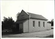
The Good Templars' Hall was the first public use building in Gingin. A branch of the 'Order of Good Templars', known as Cheriton Lodge 19, was formed in Gingin in 1875, largely at the instigation of Henry Brockman They built a Hall of baked clay bricks, the day obtained from a gully at the rear of the block. T.J. Jones donated land. It was formally opened in June of 1879. Corrugated iron was used for additions. The Hall was used for Roads Board meetings, dances and other social events. It served as the local Schoolroom from the mid 1880's until a new School was built in 1895. In October 1925, the Roads Board decided to demolish the Hall as the Temperance organisation was virtually disbanded and the Hall in disrepair. Some of the materials were used by Richard Masters to build a house at Dee Swamp. A house was built there for the Shire Clerk in 1967 and later purchased by Mr N.H.V. Wallace.
Site only of Hall - the tree remains.
| Ref ID No | Ref Name | Ref Source | Ref Date |
|---|---|---|---|
| H Udell: "History of Gingin". |
This information is provided voluntarily as a public service. The information provided is made available in good faith and is derived from sources believed to be reliable and accurate. However, the information is provided solely on the basis that readers will be responsible for making their own assessment of the matters discussed herein and are advised to verify all relevant representations, statements and information.
Brand Hwy Gingin
Gingin
Avon Arc
Constructed from 1860
| Type | Status | Date | Documents |
|---|---|---|---|
| (no listings) |
| Type | Status | Date | Documents |
|---|---|---|---|
| (no listings) |
| Type | Status | Date | Grading/Management | |
|---|---|---|---|---|
| Category | ||||
| Municipal Inventory | Adopted | 18 Oct 2005 | Category D | |
Individual Building or Group
| Epoch | General | Specific |
|---|---|---|
| Original Use | RESIDENTIAL | Single storey residence |
| Present Use | FARMING\PASTORAL | Other |
| Type | General | Specific |
|---|---|---|
| Wall | EARTH | Adobe {Mud Brick} |
| General | Specific |
|---|---|
| PEOPLE | Early settlers |
| OCCUPATIONS | Grazing, pastoralism & dairying |
| DEMOGRAPHIC SETTLEMENT & MOBILITY | Settlements |
This information is provided voluntarily as a public service. The information provided is made available in good faith and is derived from sources believed to be reliable and accurate. However, the information is provided solely on the basis that readers will be responsible for making their own assessment of the matters discussed herein and are advised to verify all relevant representations, statements and information.
Constructed from 1860
All that remains of the mud bat homestead and outbuildings is a stone well. The land is currently used for pasture.
Ralph Dewar selected SL 292 of 189 acres in July 1860. This land was immediately south west of that owned by his brother, William Smart Dewar. Ralph married Frances Carson, daughter of Alfred Carson. They had two children but unfortunately Ralph was killed when a cart overturned in February of 1861. All that remains of the mud bat homestead and outbuildings is a stone well. A fine watercolour remains in his descendants' keeping.
Remnants Only
| Ref ID No | Ref Name | Ref Source | Ref Date |
|---|---|---|---|
| H Udell: "History of Gingin". |
This information is provided voluntarily as a public service. The information provided is made available in good faith and is derived from sources believed to be reliable and accurate. However, the information is provided solely on the basis that readers will be responsible for making their own assessment of the matters discussed herein and are advised to verify all relevant representations, statements and information.
Brand Hwy Gingin
Hillview
The Farm
Gingin
Avon Arc
Constructed from 1862
| Type | Status | Date | Documents |
|---|---|---|---|
| (no listings) |
| Type | Status | Date | Documents |
|---|---|---|---|
| (no listings) |
| Type | Status | Date | Grading/Management | |
|---|---|---|---|---|
| Category | ||||
| Municipal Inventory | Adopted | 18 Oct 2005 | Category D | |
Individual Building or Group
| Epoch | General | Specific |
|---|---|---|
| Original Use | FARMING\PASTORAL | Homestead |
| Other Use | EDUCATIONAL | Combined School |
| Type | General | Specific |
|---|---|---|
| Wall | EARTH | Adobe {Mud Brick} |
| Wall | STONE | Limestone |
| Roof | TIMBER | Shingle |
| General | Specific |
|---|---|
| OCCUPATIONS | Grazing, pastoralism & dairying |
| SOCIAL & CIVIC ACTIVITIES | Education & science |
| DEMOGRAPHIC SETTLEMENT & MOBILITY | Settlements |
This information is provided voluntarily as a public service. The information provided is made available in good faith and is derived from sources believed to be reliable and accurate. However, the information is provided solely on the basis that readers will be responsible for making their own assessment of the matters discussed herein and are advised to verify all relevant representations, statements and information.
Constructed from 1862
The masonry was mud bat plus limestone and ironstone with floors of sawn timber blocks. The roof was shingled. The main house consisted of three rooms, living and bedrooms, a separate kitchen and store rooms, dairy with cellar below, stables, cowsheds and an underground fresh water tank, etc.
In 1862, 23 acres were surveyed for W.S. Dewar. He married Emma York of Creaton. A flourishing farm establishment once stood here as attested by a watercolour painting owned by descendants. The home was built on the bank of a winter stream, which flows through the Dewar flats. John York, who was William's father-in-law, built the house, presumably in 1862. Part of the old house was used as a Schoolroom for several years c 1903. The whole establishment was completely burnt out by a disastrous fire in 1914. It had not been occupied for some time. The property was transferred to W.G. (Gladstone) Dewar, grandson of W.S. Dewar and is now owned by his daughter, Marion Bird. Biddaminnie School - In 1903 The Education Department received a petition from settlers north of Gingin re the establishment of schools at Biddaminnie (W.A. Dewar's home on SL 183) and Bootine. The old homestead was not occupied and a Schoolroom was prepared by opening a doorway in the end room of the old kitchen. In approximately 1908, this School operated (half time) with Bootine until 1909, when due to poor attendances both schools were operated from Biddaminnie.
Site Only
This information is provided voluntarily as a public service. The information provided is made available in good faith and is derived from sources believed to be reliable and accurate. However, the information is provided solely on the basis that readers will be responsible for making their own assessment of the matters discussed herein and are advised to verify all relevant representations, statements and information.
Lot 2 Brand Hwy Gingin
Beauly
Gingin
Avon Arc
Constructed from 1890
| Type | Status | Date | Documents |
|---|---|---|---|
| (no listings) |
| Type | Status | Date | Documents |
|---|---|---|---|
| (no listings) |
| Type | Status | Date | Grading/Management | |
|---|---|---|---|---|
| Category | ||||
| Municipal Inventory | Adopted | 17 Nov 1994 | Category D | |
Remains have been removed.
Individual Building or Group
| Epoch | General | Specific |
|---|---|---|
| Original Use | RESIDENTIAL | Single storey residence |
| Present Use | OTHER | Other |
| Type | General | Specific |
|---|---|---|
| Wall | EARTH | Adobe {Mud Brick} |
| Wall | STONE | Other Stone |
This information is provided voluntarily as a public service. The information provided is made available in good faith and is derived from sources believed to be reliable and accurate. However, the information is provided solely on the basis that readers will be responsible for making their own assessment of the matters discussed herein and are advised to verify all relevant representations, statements and information.
Constructed from 1890
A mud bat home was erected for W R Williams on the property of his friend Henry Brockman. The house was named 'Dacresfield' after Mr. Williams' Father, Rev. Dacre Williams, the first Headmaster at Perth Boys' School. Mr. Williams was the first Secretary of the Gingin Roads Board following the first elections on 21st March 1893 The house is now a ruin having been badly damaged by troops during World War 1. The land is presently owned by Westralian Sands Ltd. of Capel W.A. The stones are to be removed and used to construct barbeques at Granville Park.
Site Only
| Ref ID No | Ref Name | Ref Source | Ref Date |
|---|---|---|---|
| Holroyd; "National Estate Study". |
This information is provided voluntarily as a public service. The information provided is made available in good faith and is derived from sources believed to be reliable and accurate. However, the information is provided solely on the basis that readers will be responsible for making their own assessment of the matters discussed herein and are advised to verify all relevant representations, statements and information.
9 Brandis St Gingin
Gingin
Avon Arc
Constructed from 1890
| Type | Status | Date | Documents |
|---|---|---|---|
| (no listings) |
| Type | Status | Date | Documents |
|---|---|---|---|
| (no listings) |
| Type | Status | Date | Grading/Management | |
|---|---|---|---|---|
| Category | ||||
| Municipal Inventory | Adopted | 18 Oct 2005 | Category C | |
Very good
Individual Building or Group
| Epoch | General | Specific |
|---|---|---|
| Original Use | RESIDENTIAL | Single storey residence |
| Present Use | RESIDENTIAL | Single storey residence |
| Type | General | Specific |
|---|---|---|
| Roof | METAL | Corrugated Iron |
| Wall | BRICK | Other Brick |
| General | Specific |
|---|---|
| DEMOGRAPHIC SETTLEMENT & MOBILITY | Settlements |
This information is provided voluntarily as a public service. The information provided is made available in good faith and is derived from sources believed to be reliable and accurate. However, the information is provided solely on the basis that readers will be responsible for making their own assessment of the matters discussed herein and are advised to verify all relevant representations, statements and information.
Constructed from 1890
A large imposing home built of bricks with an iron roof. It has a wide central passage with four main bedrooms. Utility rooms at the rear are under the original roof, though these have been altered and added to over the years. The roof was covered with a metal mock tile in terracotta in 1976. There is a cellar below, which is very damp. The original wooden verandah has been concreted. This is a charming house with many attractive decorative features
The block was originally owned by John Sims and then inherited by his daughter Jane, who married Harry Wells. Harry built this home of brick with an iron roof.
Very Good
| Ref ID No | Ref Name | Ref Source | Ref Date |
|---|---|---|---|
| H Udell: "History of Gingin". |
This information is provided voluntarily as a public service. The information provided is made available in good faith and is derived from sources believed to be reliable and accurate. However, the information is provided solely on the basis that readers will be responsible for making their own assessment of the matters discussed herein and are advised to verify all relevant representations, statements and information.
Breera Rd Gingin
Gingin
Avon Arc
| Type | Status | Date | Documents |
|---|---|---|---|
| (no listings) |
| Type | Status | Date | Documents |
|---|---|---|---|
| (no listings) |
| Type | Status | Date | Grading/Management | |
|---|---|---|---|---|
| Category | ||||
| (no listings) | ||||
Tree
| Epoch | General | Specific |
|---|---|---|
| Present Use | OTHER | Other |
| Original Use | OTHER | Other |
This information is provided voluntarily as a public service. The information provided is made available in good faith and is derived from sources believed to be reliable and accurate. However, the information is provided solely on the basis that readers will be responsible for making their own assessment of the matters discussed herein and are advised to verify all relevant representations, statements and information.
Cnr Brockman & Weld Sts Gingin
Gingin
Avon Arc
Constructed from 1920
| Type | Status | Date | Documents |
|---|---|---|---|
| Heritage List | Adopted | 17 Oct 2017 |
| Type | Status | Date | Documents |
|---|---|---|---|
| RHP - Does not warrant assessment | Current | 31 Aug 2007 |
| Type | Status | Date | Grading/Management | |
|---|---|---|---|---|
| Category | ||||
| Municipal Inventory | Adopted | 17 Oct 2017 | Category A | |
| Statewide War Memorial Survey | Completed | 01 May 1996 | ||
Historic site
| Epoch | General | Specific |
|---|---|---|
| Original Use | MONUMENT\CEMETERY | Monument |
| Present Use | MONUMENT\CEMETERY | Monument |
| Type | General | Specific |
|---|---|---|
| Other | STONE | Granite |
| Other | METAL | Other Metal |
| General | Specific |
|---|---|
| OUTSIDE INFLUENCES | World Wars & other wars |
This information is provided voluntarily as a public service. The information provided is made available in good faith and is derived from sources believed to be reliable and accurate. However, the information is provided solely on the basis that readers will be responsible for making their own assessment of the matters discussed herein and are advised to verify all relevant representations, statements and information.
Constructed from 1920
Gingin War Memorial commemorates Gingin and districts residents who went to war and is an important site of remembrance.
Elegant stone obelisk on graduated plinths.
Originally located in front of the Roads Board Office in Constable Street, unveiled by the premier Sir Henry Lefroy in 1920. It was relocated to the gardens on the south side of the Shire of Gingin Administration Offices in 1978. The memorial commemorates Gingin and districts residents who went to war. In World War One there were 47 who served and 10 who died in services. In World War Two eight died in service. A separate plaque honours of Jim Gordon who received the Victoria Cross on 12 July 1942.
Integrity: High degree Authenticity: High degree
Good
| Ref ID No | Ref Name | Ref Source | Ref Date |
|---|---|---|---|
| H Udell: "History of Gingin". p 154 & 276 |
| Owner | Category |
|---|---|
| Shire of Gingin | Local Gov't |
This information is provided voluntarily as a public service. The information provided is made available in good faith and is derived from sources believed to be reliable and accurate. However, the information is provided solely on the basis that readers will be responsible for making their own assessment of the matters discussed herein and are advised to verify all relevant representations, statements and information.
Brockman St Gingin
Gingin
Avon Arc
| Type | Status | Date | Documents |
|---|---|---|---|
| (no listings) |
| Type | Status | Date | Documents |
|---|---|---|---|
| (no listings) |
| Type | Status | Date | Grading/Management | |
|---|---|---|---|---|
| Category | ||||
| Municipal Inventory | Adopted | 18 Oct 2005 | Category C | |
11793 Gingin Primary School - Site
Garden
| Epoch | General | Specific |
|---|---|---|
| Present Use | PARK\RESERVE | Park\Reserve |
| Original Use | EDUCATIONAL | Combined School |
This information is provided voluntarily as a public service. The information provided is made available in good faith and is derived from sources believed to be reliable and accurate. However, the information is provided solely on the basis that readers will be responsible for making their own assessment of the matters discussed herein and are advised to verify all relevant representations, statements and information.
Plaque on one of the sugar gums.
The first Gingin School was built here in 1895. These trees were planted by school children on Arbour Day, 1899.
This information is provided voluntarily as a public service. The information provided is made available in good faith and is derived from sources believed to be reliable and accurate. However, the information is provided solely on the basis that readers will be responsible for making their own assessment of the matters discussed herein and are advised to verify all relevant representations, statements and information.
16 Brockman St Gingin
Cnr Brockman & Constable Streets
Gingin
Avon Arc
Constructed from 1886
| Type | Status | Date | Documents |
|---|---|---|---|
| Heritage List | Adopted | 17 Oct 2017 | |
| State Register | Registered | 27 Feb 1996 | HCWebsite.Listing+ListingDocument, HCWebsite.Listing+ListingDocument |
| Type | Status | Date | Documents |
|---|---|---|---|
| (no listings) |
| Type | Status | Date | Grading/Management | |
|---|---|---|---|---|
| Category | ||||
| Statewide Post Office Survey | Completed | 01 Mar 1992 | ||
| Classified by the National Trust | Recorded | 05 Mar 1979 | ||
| Municipal Inventory | Adopted | 17 Oct 2017 | Category A | |
Very good
| Name | Type | Year From | Year To |
|---|---|---|---|
| George Temple Poole | Architect | - | - |
Individual Building or Group
| Epoch | General | Specific |
|---|---|---|
| Present Use | Transport\Communications | Comms: Post or Telegraph Office |
| Original Use | Transport\Communications | Comms: Post or Telegraph Office |
| Present Use | RESIDENTIAL | Single storey residence |
| Style |
|---|
| Victorian Georgian |
| Type | General | Specific |
|---|---|---|
| Wall | BRICK | Rendered Brick |
| Wall | RENDER | Roughcast |
| Roof | TILE | Cement Tile |
| General | Specific |
|---|---|
| SOCIAL & CIVIC ACTIVITIES | Law & order |
| DEMOGRAPHIC SETTLEMENT & MOBILITY | Government policy |
| TRANSPORT & COMMUNICATIONS | Mail services |
| OCCUPATIONS | Technology & technological change |
| DEMOGRAPHIC SETTLEMENT & MOBILITY | Technology & technological change |
| TRANSPORT & COMMUNICATIONS | Technology & technological change |
| TRANSPORT & COMMUNICATIONS | Telecommunications |
This information is provided voluntarily as a public service. The information provided is made available in good faith and is derived from sources believed to be reliable and accurate. However, the information is provided solely on the basis that readers will be responsible for making their own assessment of the matters discussed herein and are advised to verify all relevant representations, statements and information.
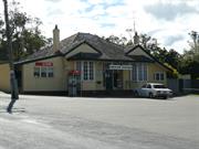
Constructed from 1886
Gingin Post Office is significant as a rare example of the Colonial Government's post office building program and is the oldest extant purpose built post office in Western Australia. It represents the vigorous lobbying by the Gingin community for its construction and the associated connection to the telegraph line from Perth to Geraldton. It represents the complementary association between police and postal service in the early development of public facilities. The residence demonstrates the role and lifestyle of the postmaster at the time.
The masonry building faces Constable Street in an elevated position overlooking the town. The building is domestic in scale and design. The frontage is symmetrical with two protruding bays rooms with faceted bay windows flanking the central entry. The hipped tiled roof continues over the central entry with gablets to the flanking elements. Additions on both sides of the frontage have break pitch skillion extensions of the main roof.
The first mail service to Gingin (at WL Brockman's property) was in 1853 on the Champion Bay route. In 1854 John York set up post office at Creaton, becoming the first post master and Registrar, until 1863. Mrs Tyler, the policeman's wife, and school mistress who lived near the police paddock in the establishing town, became post mistress, and in 1864 John Cockram was contracted for the monthly mail delivery. In 1881 Mrs Hackett was Postmistress, with mail distributed through the Police station. Tenders for the Post Office quarters were called on 20 August 1886. It was constructed by Chas Smith on Police reserve land next to police station. Officially opened on 28 October 1886. Mr and Mrs Hackett resided there 1893-1914 with Mrs being the Postmistress and Mr being the police officer (until 1893). George Temple Poole was the Government Architect of the period, and his design influence is evident in Gingin Post Office and the other six that were built to the same design in that period; Pingelly, Narrogin, Wagin, Katanning, Broomehill, Mt Barker.
Integrity: High degree Authenticity: Moderate degree
Good
| Ref ID No | Ref Name | Ref Source | Ref Date |
|---|---|---|---|
| Dr I H Van Bremen; "Thesis submission for the Doctorate of Philosophy- Dept of Architecture". | UWA | 1990 |
This information is provided voluntarily as a public service. The information provided is made available in good faith and is derived from sources believed to be reliable and accurate. However, the information is provided solely on the basis that readers will be responsible for making their own assessment of the matters discussed herein and are advised to verify all relevant representations, statements and information.
4 Brockman St Gingin
Gingin
Avon Arc
Constructed from 1903
| Type | Status | Date | Documents |
|---|---|---|---|
| (no listings) |
| Type | Status | Date | Documents |
|---|---|---|---|
| (no listings) |
| Type | Status | Date | Grading/Management | |
|---|---|---|---|---|
| Category | ||||
| Municipal Inventory | Adopted | 17 Nov 1994 | Category C | |
Individual Building or Group
| Epoch | General | Specific |
|---|---|---|
| Present Use | COMMERCIAL | Office or Administration Bldg |
| Original Use | RESIDENTIAL | Single storey residence |
| Type | General | Specific |
|---|---|---|
| Wall | STONE | Local Stone |
| Roof | TILE | Other Tile |
This information is provided voluntarily as a public service. The information provided is made available in good faith and is derived from sources believed to be reliable and accurate. However, the information is provided solely on the basis that readers will be responsible for making their own assessment of the matters discussed herein and are advised to verify all relevant representations, statements and information.
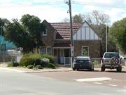
Constructed from 1903
A unique part of the Gingin shopping centre.
A quaint cottage in the centre of the Gingin shopping area, surrounded by a very attractive garden. In 2010 Tom and Angela Cabassi replaced the roof tiles and renovated the interior almost back to original.
The cottage was built c 1903 by the owner, William Philbey. Mr. Philbey, who was the Roads Board Secretary at the time, quarried, carried in his wheelbarrow and laid the limestone blocks, which form the walls of the house. He was also carpenter and plasterer and even made the lead light windows and woodcarvings. It is basically four rooms with a central passage; a kitchen was added at the rear. An attic in the roof has never been used as living quarters. A unique part of the Gingin Shopping area, this house was occupied by Mr. Philbey until his death in 1933, when he died on the premises. The house belonged in succession to C.P. Knight, J.Y. Dewar, and G.S. Giles and was bought in 1961 by A.N. & N.F. Lucraft, who had the Shop next door. Mr. & Mrs. I Evans renovated the house in the early 1990's. It is presently owned by Angela and Tom Cabassi and is used as a Real Estate Office.
| Ref ID No | Ref Name | Ref Source | Ref Date |
|---|---|---|---|
| H Udell: "History of Gingin". |
| Owner | Category |
|---|---|
| T & A Cabassi | Other Private |
This information is provided voluntarily as a public service. The information provided is made available in good faith and is derived from sources believed to be reliable and accurate. However, the information is provided solely on the basis that readers will be responsible for making their own assessment of the matters discussed herein and are advised to verify all relevant representations, statements and information.
Lot 370 Brockman St Gingin
Gingin
Avon Arc
Constructed from 1893
| Type | Status | Date | Documents |
|---|---|---|---|
| (no listings) |
| Type | Status | Date | Documents |
|---|---|---|---|
| (no listings) |
| Type | Status | Date | Grading/Management | |
|---|---|---|---|---|
| Category | ||||
| Municipal Inventory | Adopted | 17 Nov 1994 | Category D | |
Site only
| Library Id | Title | Medium | Year Of Publication |
|---|
Historic Site
| Epoch | General | Specific |
|---|---|---|
| Original Use | EDUCATIONAL | Primary School |
| Present Use | PARK\RESERVE | Park\Reserve |
| Type | General | Specific |
|---|---|---|
| Roof | METAL | Corrugated Iron |
| Wall | BRICK | Other Brick |
This information is provided voluntarily as a public service. The information provided is made available in good faith and is derived from sources believed to be reliable and accurate. However, the information is provided solely on the basis that readers will be responsible for making their own assessment of the matters discussed herein and are advised to verify all relevant representations, statements and information.
Constructed from 1893
The site is of interest to many local residents who went to school there. Many of them still hold the view that it was in sound condition and should never have been demolished.
Shire offices constructed on site in 1968.
In 1893, four acres of SL370, adjoining St Luke's Church were resumed by the Education Department and eight hundred pounds allocated to build a School. Earlier lessons had been held in the Church and other venues around Gingin. Construction began in late 1894, the building consisting of one room 32 feet by 21 feet, brick with iron roofing. The school was opened in May 1895, expected attendance 73 children. Mr. Nadebaum replaced the first Headmaster, Mr. A.E. Liddington, in 1900. In 1905 plans for additions were drawn up for a separate weatherboard and iron manual training room. In 1917a second classroom was added to the north side of the School and a front porch and steps were added to face Brockman St. The school was demolished in 1965. The present day Gingin Shire Council buildings stand just above the site. Landmark Gum trees remain close to Brockman St, they are believed to have been planted by school children on Arbour Day in 1899.
Site Only
| Ref ID No | Ref Name | Ref Source | Ref Date |
|---|---|---|---|
| H Udell: "History of Gingin". p 43 & 178 |
| Owner | Category |
|---|---|
| Shire of Gingin | Local Gov't |
This information is provided voluntarily as a public service. The information provided is made available in good faith and is derived from sources believed to be reliable and accurate. However, the information is provided solely on the basis that readers will be responsible for making their own assessment of the matters discussed herein and are advised to verify all relevant representations, statements and information.
11 Brook St Gingin
Glen Ayr
Tipperton Tiverton
Gingin
Avon Arc
Constructed from 1849
| Type | Status | Date | Documents |
|---|---|---|---|
| (no listings) |
| Type | Status | Date | Documents |
|---|---|---|---|
| (no listings) |
| Type | Status | Date | Grading/Management | |
|---|---|---|---|---|
| Category | ||||
| Municipal Inventory | Adopted | 18 Oct 2005 | ||
Historic Site
| Epoch | General | Specific |
|---|---|---|
| Original Use | RESIDENTIAL | Single storey residence |
| Type | General | Specific |
|---|---|---|
| Wall | STONE | Local Stone |
| General | Specific |
|---|---|
| PEOPLE | Early settlers |
This information is provided voluntarily as a public service. The information provided is made available in good faith and is derived from sources believed to be reliable and accurate. However, the information is provided solely on the basis that readers will be responsible for making their own assessment of the matters discussed herein and are advised to verify all relevant representations, statements and information.
Constructed from 1849
Site of the home of early settlers.
Standing on a stone platform, the house had Casuarina stone walls. Palms, a large Olive tree and some English trees are all that remain of the garden.
The house was situated on the south side of the Gingin Brook. Joshua and Emma Edwards built a home there. Their eldest daughter was bom in 1849 and another eight daughters and a son (Reuben) were born later. The house faced north across Gingin Brook. Joshua died suddenly on 26th October 1866. Emma remarried James Anderson on 27th October in 1868. She placed the property into the hands of trustees until their only son, Reuben, turned 21. The property was heavily mortgaged and much of it was lost. The roof of the house was removed by John Musk and in c 1915 the house burnt down. A large olive tree remains.
Site Only
| Ref ID No | Ref Name | Ref Source | Ref Date |
|---|---|---|---|
| H Udell: "History of Gingin". |
This information is provided voluntarily as a public service. The information provided is made available in good faith and is derived from sources believed to be reliable and accurate. However, the information is provided solely on the basis that readers will be responsible for making their own assessment of the matters discussed herein and are advised to verify all relevant representations, statements and information.
7 Brook St Gingin
Gingin
Avon Arc
Constructed from 1880
| Type | Status | Date | Documents |
|---|---|---|---|
| (no listings) |
| Type | Status | Date | Documents |
|---|---|---|---|
| (no listings) |
| Type | Status | Date | Grading/Management | |
|---|---|---|---|---|
| Category | ||||
| Municipal Inventory | Adopted | 18 Oct 2005 | Category C | |
Individual Building or Group
| Epoch | General | Specific |
|---|---|---|
| Original Use | RESIDENTIAL | Single storey residence |
| Other Use | HEALTH | Other |
| Type | General | Specific |
|---|---|---|
| Roof | METAL | Corrugated Iron |
| Wall | EARTH | Adobe {Mud Brick} |
| General | Specific |
|---|---|
| DEMOGRAPHIC SETTLEMENT & MOBILITY | Aboriginal Occupation |
| DEMOGRAPHIC SETTLEMENT & MOBILITY | Settlements |
This information is provided voluntarily as a public service. The information provided is made available in good faith and is derived from sources believed to be reliable and accurate. However, the information is provided solely on the basis that readers will be responsible for making their own assessment of the matters discussed herein and are advised to verify all relevant representations, statements and information.
Constructed from 1880
This was a solid example of mud bat construction.
There were three main rooms in a row and a small room on the South East corner. It had front and back verandahs. All except 2 of the windows were original, 6 pane pivot windows, - one of which was hinged on after the house was built, and one replaced. The original top panels of two of the front doors opening onto the southern verandah did not have the small glass panes - only one door was probably as originally constructed. Fireplaces of kitchen and living area backed onto each other, the cooking fireplace raised and deep but small width, and the log fireplace wide and shallow. Floor boards were originals in the three main rooms, and had been renewed in the small bedroom.The original ceilings had been replaced. The house occupied a large block close to the Gingin Brook on the southern side of The Horseshoe.
Believed to have been built by Frederick Felix Hill in the 1880's. Another story says G. Butler built it. F.F. Hill and his family lived here until he built a new home in Constable St (builder of that home was G. Butler), which is now Thorn's House. This house was purchased in the early 1920's by Zaccariah Brown and then by Mr. & Mrs. Noel Lucraft in 1948. It served as a Doctor's Surgery (B. Williams) in the late 1970's and a private residence since then. It was then owned an occupied by K & L Tipping who were planning to renovate until tragically a fire burnt majority of the house on 23 November 2006. The walls and fireplace still remain on the stone foundation of the three main rooms. A small room on the South East corner of the house was not affected by the fire, however, the winter rains has slowly collapsed and washed the mud wall away.
| Ref ID No | Ref Name | Ref Source | Ref Date |
|---|---|---|---|
| H Udell: "History of Gingin". |
| Owner | Category |
|---|---|
| K & L Tipping | Other Private |
This information is provided voluntarily as a public service. The information provided is made available in good faith and is derived from sources believed to be reliable and accurate. However, the information is provided solely on the basis that readers will be responsible for making their own assessment of the matters discussed herein and are advised to verify all relevant representations, statements and information.
Cheriton Rd Gingin
Gooch House
Gingin
Avon Arc
Constructed from 1845
| Type | Status | Date | Documents |
|---|---|---|---|
| Heritage List | Adopted | 17 Oct 2017 |
| Type | Status | Date | Documents |
|---|---|---|---|
| (no listings) |
| Type | Status | Date | Grading/Management | |
|---|---|---|---|---|
| Category | ||||
| Municipal Inventory | Adopted | 17 Oct 2017 | Category D | |
03404 Cheriton Estate - former Gooch House
Historic Site
| Epoch | General | Specific |
|---|---|---|
| Original Use | RESIDENTIAL | Single storey residence |
| Present Use | FARMING\PASTORAL | Other |
| Type | General | Specific |
|---|---|---|
| Roof | TIMBER | Shingle |
| Wall | STONE | Limestone |
This information is provided voluntarily as a public service. The information provided is made available in good faith and is derived from sources believed to be reliable and accurate. However, the information is provided solely on the basis that readers will be responsible for making their own assessment of the matters discussed herein and are advised to verify all relevant representations, statements and information.
Constructed from 1845
Cheriton is significant for the associations with Brockman and the northwest syndicate, that included Gooch who had the residence and managers quarters designed by prominent Architects, Oldham, Boas and Edney-Brown. The residences represent fine examples of the Architect's work of the period, and demonstrate a way of life no longer practiced.
NO SITE INSPECTION IN 2017. The main residence is reported to be a two storey masonry structure with a simple hipped roof, the manager's cottage is a single storey building with a hipped roof.
Cheriton was originally settled by WL Brockman, later a syndicate of northwest pastoralists acquired the property. Comprising Gooch, Harper, Edgar and Wedge, it was Gooch who built the main residence and the managers cottage. Materials from an original house that was located close to Gingin Brook, were used in the construction. It is considered that Architects Oldham, Boas and Edney-Brown designed both places.
| Ref ID No | Ref Name | Ref Source | Ref Date |
|---|---|---|---|
| H Udell: "History of Gingin". |
This information is provided voluntarily as a public service. The information provided is made available in good faith and is derived from sources believed to be reliable and accurate. However, the information is provided solely on the basis that readers will be responsible for making their own assessment of the matters discussed herein and are advised to verify all relevant representations, statements and information.
This information is provided voluntarily as a public service. The information provided is made available in good faith and is derived from sources believed to be reliable and accurate. However, the information is provided solely on the basis that readers will be responsible for making their own assessment of the matters discussed herein and are advised to verify all relevant representations, statements and information.
Cheriton Rd Gingin
Sunday Hill
Gingin
Avon Arc
| Type | Status | Date | Documents |
|---|---|---|---|
| (no listings) |
| Type | Status | Date | Documents |
|---|---|---|---|
| (no listings) |
| Type | Status | Date | Grading/Management | |
|---|---|---|---|---|
| Category | ||||
| Municipal Inventory | Adopted | 18 Oct 2005 | Category D | |
Landscape
| Epoch | General | Specific |
|---|---|---|
| Original Use | FARMING\PASTORAL | Other |
| Present Use | FARMING\PASTORAL | Other |
| General | Specific |
|---|---|
| OUTSIDE INFLUENCES | World Wars & other wars |
| DEMOGRAPHIC SETTLEMENT & MOBILITY | Settlements |
This information is provided voluntarily as a public service. The information provided is made available in good faith and is derived from sources believed to be reliable and accurate. However, the information is provided solely on the basis that readers will be responsible for making their own assessment of the matters discussed herein and are advised to verify all relevant representations, statements and information.
During the Second World War, this hill was the site of an American unit encampment. U.S.A. 699th Air Warning Battalion were here from March 1942 to sometime later in that year. Fifty men in this Radar Detection Unit camped on the hillside in a clump of trees. There was a well with a good supply of water nearby.
The hill is situated three kilometers north of Gingin. From the top of Sunday Hill there is an uninterrupted view 180° north and south and west to the coast.
In 1843, SL 101 was surveyed for W.L. Brockman. He leased the land around and bought SL459 in 1867. The name 'Ginginup' was given by the Aborigines, believed to mean 'water flowing between two hills'. It was shortened to Gingin by early settlers and became a place name of the nearby Town and district. When it was sold to Harper Edgar and Wedge in 1895, it became part of Edgar's farm. The Edgar family called it 'Sunday Hill', as they used to picnic there on Sundays.
| Ref ID No | Ref Name | Ref Source | Ref Date |
|---|---|---|---|
| I Edgar; "Reminiscences". | Unpublished Article |
This information is provided voluntarily as a public service. The information provided is made available in good faith and is derived from sources believed to be reliable and accurate. However, the information is provided solely on the basis that readers will be responsible for making their own assessment of the matters discussed herein and are advised to verify all relevant representations, statements and information.
Cheriton Rd Gingin
Shaddow Downs
Gingin
Avon Arc
Constructed from 1900
| Type | Status | Date | Documents |
|---|---|---|---|
| (no listings) |
| Type | Status | Date | Documents |
|---|---|---|---|
| RHP - Assessed - Below Threshold | Current | 25 Oct 1996 |
| Type | Status | Date | Grading/Management | |
|---|---|---|---|---|
| Category | ||||
| Register of the National Estate | Permanent | 28 Sep 1982 | ||
| Classified by the National Trust | Classified | 03 Jul 1978 | ||
| Municipal Inventory | Adopted | 17 Nov 1994 | Category C | |
Very good
Individual Building or Group
| Epoch | General | Specific |
|---|---|---|
| Present Use | FARMING\PASTORAL | Homestead |
| Original Use | FARMING\PASTORAL | Homestead |
| Style |
|---|
| Federation Academic Classical |
| Type | General | Specific |
|---|---|---|
| Wall | STONE | Other Stone |
This information is provided voluntarily as a public service. The information provided is made available in good faith and is derived from sources believed to be reliable and accurate. However, the information is provided solely on the basis that readers will be responsible for making their own assessment of the matters discussed herein and are advised to verify all relevant representations, statements and information.
Constructed from 1900
The homestead is delightfuly situated on a slight elevation below Mount Ginginup in the Cheriton valley. The walls are diatomaceous earth which was quarried on the property. Windows and doors and comers of the house are framed in red brick. The house is surrounded by a verandah with a bull nose iron roof. All rooms have a fireplace. The house has a central hallway. The roof is high pitched and topped by four double chimneys and one single high chimney. Renovation has modified the original Edwardian character of the house. The property has been upgraded and extended to a modern residence. There is a Swimming Pool under the main roof.
Very Good
| Owner | Category |
|---|---|
| Schofield, Vernon & Christine Anne | Other Private |
This information is provided voluntarily as a public service. The information provided is made available in good faith and is derived from sources believed to be reliable and accurate. However, the information is provided solely on the basis that readers will be responsible for making their own assessment of the matters discussed herein and are advised to verify all relevant representations, statements and information.
Built by a retired north-west pastoralist is it a gracious example of a well-to-do Gentleman's Residence in the closing years of the colonial period.
Assessment 1978 Construction 1899
Built in 1899 this large limestone house is a find example of Victorian architecture. The walls are constructed of diatomaceous stone with brick quoins and the hipped roof is of corrugated iron. The gracious bullnosed verandah surrounds the homestead. It has been owned continuously by the same family
This information is provided voluntarily as a public service. The information provided is made available in good faith and is derived from sources believed to be reliable and accurate. However, the information is provided solely on the basis that readers will be responsible for making their own assessment of the matters discussed herein and are advised to verify all relevant representations, statements and information.
183 Cheriton Rd Gingin
Gingin
Avon Arc
Constructed from 1903
| Type | Status | Date | Documents |
|---|---|---|---|
| (no listings) |
| Type | Status | Date | Documents |
|---|---|---|---|
| (no listings) |
| Type | Status | Date | Grading/Management | |
|---|---|---|---|---|
| Category | ||||
| Municipal Inventory | Adopted | 18 Oct 2005 | Category C | |
| Register of the National Estate | Permanent | 28 Sep 1982 | ||
03404 Cheriton Estate - former Gooch House
| Name | Type | Year From | Year To |
|---|---|---|---|
| Oldham, Boas & Edney Brown (probably responsible for design of house) | Architect | - | - |
Individual Building or Group
| Epoch | General | Specific |
|---|---|---|
| Present Use | RESIDENTIAL | Single storey residence |
| Original Use | RESIDENTIAL | Single storey residence |
| Style |
|---|
| Federation Bungalow |
| Type | General | Specific |
|---|---|---|
| Wall | BRICK | Other Brick |
| Roof | METAL | Corrugated Iron |
| Wall | STONE | Limestone |
| General | Specific |
|---|---|
| OCCUPATIONS | Grazing, pastoralism & dairying |
| OCCUPATIONS | Commercial & service industries |
| DEMOGRAPHIC SETTLEMENT & MOBILITY | Settlements |
This information is provided voluntarily as a public service. The information provided is made available in good faith and is derived from sources believed to be reliable and accurate. However, the information is provided solely on the basis that readers will be responsible for making their own assessment of the matters discussed herein and are advised to verify all relevant representations, statements and information.
Built in 1902 this cottage is considered a most advanced type of accommodation to be provided for a manager. As such it is the best example of the Gingin district.
This limestone cottage with brick quoins, corrugated iron hipped roof and bull nose verandah was built in 1902 by Mr G.J. Gooch using limestone from the old homestead beside the Gingin Brook. The verandah was restored using timber from the old stable.
Assessment 1980
This information is provided voluntarily as a public service. The information provided is made available in good faith and is derived from sources believed to be reliable and accurate. However, the information is provided solely on the basis that readers will be responsible for making their own assessment of the matters discussed herein and are advised to verify all relevant representations, statements and information.
Constructed from 1903
The house is in relatively original condition with verandah intact and is part of the original ensemble of house and farm buildings.
Single storey house designed in the manner customary at the turn of the century. Probably designed by the architcts, Oldam, Boas and Edney Brown who were responsible for the main building. This limestone cottage with brick quoins, corrugated iron, hipped roof and bull nose verandah was built in 1902 by Mr G J Gooch, using limestone from the old homestead beside the Gingin Brook. The verandah was restored using timber from the old stable. It remains in excellent order.
Built by G. Gooch at the same time as the larger house called Cheriton and on the same site. The first Cheriton, a farmhouse located on Gingin Brook, was demolished and the material was used in the construction of the new buildings.
This information is provided voluntarily as a public service. The information provided is made available in good faith and is derived from sources believed to be reliable and accurate. However, the information is provided solely on the basis that readers will be responsible for making their own assessment of the matters discussed herein and are advised to verify all relevant representations, statements and information.
183 Cheriton Rd Gingin
Inc: Manager's House and Stallion Box - both on RNE Cheriton Arch moved into town
Gingin
Avon Arc
Constructed from 1903
| Type | Status | Date | Documents |
|---|---|---|---|
| (no listings) |
| Type | Status | Date | Documents |
|---|---|---|---|
| (no listings) |
| Type | Status | Date | Grading/Management | |
|---|---|---|---|---|
| Category | ||||
| Municipal Inventory | Adopted | 18 Mar 2003 | Category C | |
| Register of the National Estate | Registered | 28 Sep 1982 | ||
Individual Building or Group
| Epoch | General | Specific |
|---|---|---|
| Original Use | RESIDENTIAL | Two storey residence |
| Present Use | RESIDENTIAL | Two storey residence |
| Style |
|---|
| Federation Filigree |
| Type | General | Specific |
|---|---|---|
| Roof | METAL | Corrugated Iron |
| Other | TIMBER | Other Timber |
| Wall | STONE | Limestone |
This information is provided voluntarily as a public service. The information provided is made available in good faith and is derived from sources believed to be reliable and accurate. However, the information is provided solely on the basis that readers will be responsible for making their own assessment of the matters discussed herein and are advised to verify all relevant representations, statements and information.
Constructed from 1903
For historical and architectural reasons, this is a significant site of which the extant buildings are the most important material evidence and as such are still in use.
A large two-storey house (originally with two-storey verandahs). It is characteristic internally and externally of the grand style of architecture at the turn of the century, the only example of its type in the region. Removal of the verandahs and restoration of the facades has resulted in an Italianate appearance, which belies the original architectural character.
Cheriton was originally settled by W.L. Brockman and is therefore synonymous with the settlement and opening up of the Gingin region. A syndicate of northwest pastoralists, Gooch, Harper, Edgar and Wedge, resettled in this area. George Gooch built this house.
| Ref ID No | Ref Name | Ref Source | Ref Date |
|---|---|---|---|
| H Udell: "History of Gingin". |
This information is provided voluntarily as a public service. The information provided is made available in good faith and is derived from sources believed to be reliable and accurate. However, the information is provided solely on the basis that readers will be responsible for making their own assessment of the matters discussed herein and are advised to verify all relevant representations, statements and information.
6 Church St Gingin
Connell's House
Gingin
Avon Arc
Constructed from 1890
| Type | Status | Date | Documents |
|---|---|---|---|
| (no listings) |
| Type | Status | Date | Documents |
|---|---|---|---|
| (no listings) |
| Type | Status | Date | Grading/Management | |
|---|---|---|---|---|
| Category | ||||
| Municipal Inventory | Adopted | 17 Nov 1994 | Category C | |
Individual Building or Group
| Epoch | General | Specific |
|---|---|---|
| Original Use | RESIDENTIAL | Single storey residence |
| Present Use | RESIDENTIAL | Single storey residence |
| Type | General | Specific |
|---|---|---|
| Roof | METAL | Corrugated Iron |
| Wall | BRICK | Common Brick |
| General | Specific |
|---|---|
| PEOPLE | Early settlers |
| DEMOGRAPHIC SETTLEMENT & MOBILITY | Settlements |
This information is provided voluntarily as a public service. The information provided is made available in good faith and is derived from sources believed to be reliable and accurate. However, the information is provided solely on the basis that readers will be responsible for making their own assessment of the matters discussed herein and are advised to verify all relevant representations, statements and information.
Constructed from 1890
A four-roomed brick and iron residence with a passage down the centre, verandah on three sides and utility rooms at the rear. The owner is presently renovating the building taking care to maintain its original character.
This house was built for William James King, a son of Daniel King of the Junction. He had the town's first Butcher's shop and was married to John Dewar's daughter, Selina. They had four sons and one daughter. The house was rented for some time after the King's went to Midland Junction, in the 1920's and 1930's. Mrs. Andrew Frederick Dewar lived in the house during World War 1 with her children Fred, Joe and Ruby. A little boy, Clayton, died there Mrs. Floyd Troy and family owned it in the 1970's. She was the second wife of Hubert Troy. There were three children from the first marriage to Rose Jones and then Dawn. Fay (Mrs. George Harris), Deirdre and Gavin. Mr. & Mrs. Don Hall lived there from 1975. They put in a swimming pool It has been owned for some years by Mr & Mrs. Peter Connell.
This information is provided voluntarily as a public service. The information provided is made available in good faith and is derived from sources believed to be reliable and accurate. However, the information is provided solely on the basis that readers will be responsible for making their own assessment of the matters discussed herein and are advised to verify all relevant representations, statements and information.
Cockram Rd Gingin
On Lennard's Brook
Gingin
Avon Arc
Constructed from 1870
| Type | Status | Date | Documents |
|---|---|---|---|
| (no listings) |
| Type | Status | Date | Documents |
|---|---|---|---|
| (no listings) |
| Type | Status | Date | Grading/Management | |
|---|---|---|---|---|
| Category | ||||
| Municipal Inventory | Adopted | 17 Nov 1994 | Category D | |
Individual Building or Group
| Epoch | General | Specific |
|---|---|---|
| Present Use | FARMING\PASTORAL | Other |
| Original Use | INDUSTRIAL\MANUFACTURING | Flour Mill |
This information is provided voluntarily as a public service. The information provided is made available in good faith and is derived from sources believed to be reliable and accurate. However, the information is provided solely on the basis that readers will be responsible for making their own assessment of the matters discussed herein and are advised to verify all relevant representations, statements and information.
Constructed from 1870
Historical - early flour milling.
On the east side of Lennard's Brook, just below Lennard's Brook Bridge. No relics remain
oseph Chariton applied for a tillage lease in 1865, and in 1868, he purchased Swan Locations 528 & 529 both blocks having Brook frontage, just south of the Lennard's Brook bridge. On SL 528, he built a Flourmill and mud bat cottage using material from the Brook. Grain was gristed here from 1870 to 1885. In later years a Mr. Beswick lived here growing vegetables, which he sold in Gingin. There was a butchery across Cockram Road and Mr. Beswick was also the Nightman. The town sanitary site used at that time was a small block adjoining the south of SL 529. The mud bat cottage was lived in up to the 1960's.
Site Only
| Ref ID No | Ref Name | Ref Source | Ref Date |
|---|---|---|---|
| H Udell: "History of Gingin". |
This information is provided voluntarily as a public service. The information provided is made available in good faith and is derived from sources believed to be reliable and accurate. However, the information is provided solely on the basis that readers will be responsible for making their own assessment of the matters discussed herein and are advised to verify all relevant representations, statements and information.
Cockram Rd Gingin
1km from Gingin
Coolyena
Gingin
Avon Arc
| Type | Status | Date | Documents |
|---|---|---|---|
| (no listings) |
| Type | Status | Date | Documents |
|---|---|---|---|
| (no listings) |
| Type | Status | Date | Grading/Management | |
|---|---|---|---|---|
| Category | ||||
| Municipal Inventory | Adopted | 17 Nov 1994 | Category D | |
| Register of the National Estate | Registered | 30 Jun 1992 | ||
| Register of the National Estate | Nominated | 01 Aug 1990 | ||
| Classified by the National Trust | Classified {Lscpe} | |||
| Library Id | Title | Medium | Year Of Publication |
|---|---|---|---|
| 6378 | Heritage Places - Western Australia : pamphlets. | Brochure | 2003 |
| 2398 | National Estate Program : documentation of geological sites and monuments; Nomination of geological monument for the register of the National Estate: Dingo Gap, Bugle Gap, Bringo Railway cutting, Molecap Hill, Veevers Crater, Dalgaranga Crater, North Pole, | Report | 1989 |
Landscape
| Epoch | General | Specific |
|---|---|---|
| Original Use | FARMING\PASTORAL | Other |
| Present Use | MINING | Other |
This information is provided voluntarily as a public service. The information provided is made available in good faith and is derived from sources believed to be reliable and accurate. However, the information is provided solely on the basis that readers will be responsible for making their own assessment of the matters discussed herein and are advised to verify all relevant representations, statements and information.
A landmark to the south of the town. It has geological significance.
At the summit of a hill just to the south of Gingin township is a disused Quarry. The fossils of plants and animals such as molluscs and foraminifera are found in a layer of chalk. Greensands (Glauconite) deposit mined in 1932
A small limestone hill just to the south of Gingin town site. A part of SL 103 surveyed by J.W. Gregory in 1844 The first owner was Richard Edwards and then his son, Joshua Edwards Coolyena, the Aboriginal name, was described as very rich with grasses and native yams (Warrine) with chalk and limestone underlying. Although the limestone deposit had long been known, Mr. W.B. Gordon, an amateur geologist, recognised the Greensands (Glauconite) deposit. Mr. Ralph Hill mined the glauconite in 1932. It was blasted out and trucked to the railway station and then to the Swan. The glauconite was used to soften 'hard water.' In later years the Quarry was used as a shooting range and more recently has been mined for agricultural lime. The limestone contains fossils such as molluscs and foraminifera and sharks teeth and has been a popular place for school geology excursions.
| Ref ID No | Ref Name | Ref Source | Ref Date |
|---|---|---|---|
| H Udell: "History of Gingin". |
This information is provided voluntarily as a public service. The information provided is made available in good faith and is derived from sources believed to be reliable and accurate. However, the information is provided solely on the basis that readers will be responsible for making their own assessment of the matters discussed herein and are advised to verify all relevant representations, statements and information.
Constable St Gingin
Gingin
Avon Arc
Constructed from 1911
| Type | Status | Date | Documents |
|---|---|---|---|
| Heritage List | Adopted | 17 Oct 2017 |
| Type | Status | Date | Documents |
|---|---|---|---|
| RHP - To be assessed | Current | 31 Aug 2007 |
| Type | Status | Date | Grading/Management | |
|---|---|---|---|---|
| Category | ||||
| Municipal Inventory | Adopted | 17 Oct 2017 | Category A | |
| Classified by the National Trust | Classified | 03 Jul 1978 | ||
| Register of the National Estate | Permanent | 28 Sep 1982 | ||
The Roads Board Office has social significance for its long running association with local Government and decision making in the local community.
The Roads Board Office has historical significance for the role it played in the development of the Shire of Gingin.
The Roads Board Office is rare for its aesthetic qualities.
Constructed materials are burnt bricks and a corrugated iron roof. There is one main room with an enclosed front verandah and rear facilities.
An election to form the Gingin Road Board was held in 1893 and the inaugral meeting was held in the Granville Hotel. Later meetings were held in John Dewar’s Hotel and the Good Templars Hall. Meetings were moved to the new Agricultural Hall between 1900 and 1903 and then it was decided to rent a house in Brockman Street, opposite the school. Early in 1910 plans were put forward to build a new Roads Board Office at an estimated cost of 250 pounds. Eventually Mr Tom’s tender of 310 pounds was accepted as this was the cheapest one. On April 29, 1911 Mr SF Moore MLA officially opened the new office and the Gingin Road Board at last had a permanent home. Construction materials are burnt bricks and an iron roof. There is one main room with an enclosed front verandah and rear facilities. In recent years it has been used as a Pre-school centre, a playgroup and for Red Cross meetings. It belongs to the Shire of Gingin.
Good condition
Individual Building or Group
| Epoch | General | Specific |
|---|---|---|
| Present Use | EDUCATIONAL | Pre-primary Centre |
| Original Use | EDUCATIONAL | Other |
| Type | General | Specific |
|---|---|---|
| Roof | METAL | Corrugated Iron |
| Wall | BRICK | Other Brick |
| General | Specific |
|---|---|
| DEMOGRAPHIC SETTLEMENT & MOBILITY | Settlements |
This information is provided voluntarily as a public service. The information provided is made available in good faith and is derived from sources believed to be reliable and accurate. However, the information is provided solely on the basis that readers will be responsible for making their own assessment of the matters discussed herein and are advised to verify all relevant representations, statements and information.
One of the few remaining examples of the type of office built for the use of a amller roads board prior to the 1914 - 1918 war. Of great historical signficance to WA.
This little building of brick and iron was built in 1911 for the Gingin Roads Board and was used for this purpose until 198 when new offices were built. The building now used as a pre-school centre has a centrally placed front door and unusual timber framed verandah and balustrade part of which has been filled in.
Assessment 1978 Construction 1911
This information is provided voluntarily as a public service. The information provided is made available in good faith and is derived from sources believed to be reliable and accurate. However, the information is provided solely on the basis that readers will be responsible for making their own assessment of the matters discussed herein and are advised to verify all relevant representations, statements and information.
Constructed from 1911
Gingin Road Board Office (fmr) is significant in representing the development of the local government in 1911 and of continued development when it was vacated in 1968 for new premises. It has a social and civic significance for the associations with staff and elected members throughout that period.
The building faces Constable Street in an elevated position. Modest in scale it has a single frontage with a gable and separate ski/lion front veranda. The gable has a decorative brick edge detail. The veranda is partially enclosed. There is a full width rear addition with a separate ski/lion roof.
The inaugural meeting of the Ging in Road Board was held in 1893 in Granville Hotel, later at John Dewar's Railway Hotel, and the Good Templars Hall, before the Agricultural Hall between 1900-1903 when a house in Brockman Street was rented for the purpose. On 29 April 1911 Mr Moore, MLA opened the new office comprising one main room with an enclosed front veranda and rear facilities. In 1968, new administration offices were constructed for the Shire of Gingin and the building was no longer utilised for the local government activities.
Integrity: Moderate degree Authenticity: Moderate degree
Good
| Ref ID No | Ref Name | Ref Source | Ref Date |
|---|---|---|---|
| H Udell: "History of Gingin". p 154 & 276 |
This information is provided voluntarily as a public service. The information provided is made available in good faith and is derived from sources believed to be reliable and accurate. However, the information is provided solely on the basis that readers will be responsible for making their own assessment of the matters discussed herein and are advised to verify all relevant representations, statements and information.
Constable St Gingin
CWA Rooms
Gingin
Avon Arc
Constructed from 1899
| Type | Status | Date | Documents |
|---|---|---|---|
| (no listings) |
| Type | Status | Date | Documents |
|---|---|---|---|
| (no listings) |
| Type | Status | Date | Grading/Management | |
|---|---|---|---|---|
| Category | ||||
| Municipal Inventory | Adopted | 17 Nov 1994 | Category C | |
Good
Individual Building or Group
| Epoch | General | Specific |
|---|---|---|
| Present Use | SOCIAL\RECREATIONAL | Other Community Hall\Centre |
| Original Use | EDUCATIONAL | Housing or Quarters |
| Type | General | Specific |
|---|---|---|
| Wall | BRICK | Other Brick |
| Roof | METAL | Corrugated Iron |
| General | Specific |
|---|---|
| DEMOGRAPHIC SETTLEMENT & MOBILITY | Settlements |
| SOCIAL & CIVIC ACTIVITIES | Education & science |
This information is provided voluntarily as a public service. The information provided is made available in good faith and is derived from sources believed to be reliable and accurate. However, the information is provided solely on the basis that readers will be responsible for making their own assessment of the matters discussed herein and are advised to verify all relevant representations, statements and information.
Constructed from 1899
This house was built in 1899 for the use of the Headmaster, and was possibly used for this purpose for 30 years. Fred Mitchen rented it in 1927. It was renovated and repaired by the C.W.A. in recent years. Now to be acquired for the Gingin Shire Council for public use.
Situated on a large block between Constable St and the Brook, the four front rooms were retained when the kitchen and bedrooms were demolished. In 1993 a new meeting room was added to the rear.
The home was built for the Headmaster of Gingin Primary School and completed in 1899. It was built of brick close to the footpath. Four main rooms stepped down toward the rear. Two rooms and a kitchen were added about 1902.
Good
| Ref ID No | Ref Name | Ref Source | Ref Date |
|---|---|---|---|
| H Udell: "History of Gingin". |
This information is provided voluntarily as a public service. The information provided is made available in good faith and is derived from sources believed to be reliable and accurate. However, the information is provided solely on the basis that readers will be responsible for making their own assessment of the matters discussed herein and are advised to verify all relevant representations, statements and information.
15 Constable St Gingin
Cnr Constable & Barlee St This place briefly had another P number (P17919) as there were originally two different addresses (9 and 15 Constable Street). It was determined that 15 was the most up to date street number.
Mrs Thom's House
Gingin
Avon Arc
Constructed from 1886
| Type | Status | Date | Documents |
|---|---|---|---|
| (no listings) |
| Type | Status | Date | Documents |
|---|---|---|---|
| (no listings) |
| Type | Status | Date | Grading/Management | |
|---|---|---|---|---|
| Category | ||||
| Municipal Inventory | Adopted | 18 Oct 2005 | Category C | |
| Classified by the National Trust | Classified | 03 Jul 1978 | ||
| Register of the National Estate | Permanent | 28 Sep 1982 | ||
Individual Building or Group
| Epoch | General | Specific |
|---|---|---|
| Original Use | RESIDENTIAL | Single storey residence |
| Present Use | RESIDENTIAL | Single storey residence |
| Type | General | Specific |
|---|---|---|
| Wall | STONE | Limestone |
| Other | STONE | Local Stone |
| Roof | METAL | Corrugated Iron |
| General | Specific |
|---|---|
| DEMOGRAPHIC SETTLEMENT & MOBILITY | Settlements |
This information is provided voluntarily as a public service. The information provided is made available in good faith and is derived from sources believed to be reliable and accurate. However, the information is provided solely on the basis that readers will be responsible for making their own assessment of the matters discussed herein and are advised to verify all relevant representations, statements and information.
Constructed from 1886
A historical Gingin building.
The house contains 5 main rooms and a passage from the front door. A good example of the use of local limestone in rubble stone walls with dressed stone quoins. The house has asymmetrically spaced windows to the front facade and these are unusual timber framed with small panes and sliding construction. Another interesting feature is the saw tooth bargeboard detail. Built out of local materials by the Hill family in 1886, for their own use. When the house was renovated in 2007, it was converted into 4 main rooms with the fifth room being divided into an Office, bathroom and storage room. The previous kitchen and bathroom on the back verandah have been demolished and replaced with new.
The original owner was Frederick Felix Hill who was married to Ellen Dewar. He was a Town Councillor in 1893 and worked as a contractor. F.F. Hill died in 1936 and his daughter, Clara Campbell, inherited the house. Mrs Rose Thom of Gingin now owns it. Rose Thom left the property to go into a home and later died. Her husband is also deceased. The house was renovated in 2007, when ownership was taken over by RD and IF Dewar.
Very Good
| Ref ID No | Ref Name | Ref Source | Ref Date |
|---|---|---|---|
| H Udell: "History of Gingin". |
| Owner | Category |
|---|---|
| RD & IF Dewar | Other Private |
This information is provided voluntarily as a public service. The information provided is made available in good faith and is derived from sources believed to be reliable and accurate. However, the information is provided solely on the basis that readers will be responsible for making their own assessment of the matters discussed herein and are advised to verify all relevant representations, statements and information.
3 Constable St Gingin
Gingin
Avon Arc
Constructed from 1886
| Type | Status | Date | Documents |
|---|---|---|---|
| (no listings) |
| Type | Status | Date | Documents |
|---|---|---|---|
| (no listings) |
| Type | Status | Date | Grading/Management | |
|---|---|---|---|---|
| Category | ||||
| Municipal Inventory | Adopted | 18 Oct 2005 | ||
Accretions removed from the original building which has been restored. Verandah has been added.
Individual Building or Group
| Epoch | General | Specific |
|---|---|---|
| Present Use | COMMERCIAL | Other |
| Original Use | RESIDENTIAL | Single storey residence |
| Type | General | Specific |
|---|---|---|
| Wall | EARTH | Adobe {Mud Brick} |
| General | Specific |
|---|---|
| DEMOGRAPHIC SETTLEMENT & MOBILITY | Settlements |
This information is provided voluntarily as a public service. The information provided is made available in good faith and is derived from sources believed to be reliable and accurate. However, the information is provided solely on the basis that readers will be responsible for making their own assessment of the matters discussed herein and are advised to verify all relevant representations, statements and information.
Constructed from 1886
One of the few surviving examples of a characteristic house type in Gingin.
Accretions removed from the original building which has been restored. Verandah has been added.
| Ref ID No | Ref Name | Ref Source | Ref Date |
|---|---|---|---|
| H Udell: "History of Gingin". |
This information is provided voluntarily as a public service. The information provided is made available in good faith and is derived from sources believed to be reliable and accurate. However, the information is provided solely on the basis that readers will be responsible for making their own assessment of the matters discussed herein and are advised to verify all relevant representations, statements and information.
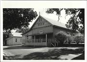
Lot 138 Constable St Gingin
Gingin
Avon Arc
Constructed from 1899
| Type | Status | Date | Documents |
|---|---|---|---|
| (no listings) |
| Type | Status | Date | Documents |
|---|---|---|---|
| (no listings) |
| Type | Status | Date | Grading/Management | |
|---|---|---|---|---|
| Category | ||||
| Classified by the National Trust | Recorded | 03 Jul 1978 | ||
| Municipal Inventory | Adopted | 18 Oct 2005 | Category D | |
Destroyed by fire.
Individual Building or Group
| Epoch | General | Specific |
|---|---|---|
| Present Use | SOCIAL\RECREATIONAL | Other Community Hall\Centre |
| Original Use | SOCIAL\RECREATIONAL | Agricultural Hall |
| Type | General | Specific |
|---|---|---|
| Wall | TIMBER | Weatherboard |
This information is provided voluntarily as a public service. The information provided is made available in good faith and is derived from sources believed to be reliable and accurate. However, the information is provided solely on the basis that readers will be responsible for making their own assessment of the matters discussed herein and are advised to verify all relevant representations, statements and information.
Constructed from 1899
This unique building was described as a weatherboard classic constructed on timber stumps and framed and clad in timber. Destroyed by fire in 1978. Now a carpark.
On an area surveyed next to the Police Station, a wooden Hall was constructed in 1899 In 1911 a verandah was added to the front and a staircase from the passage to the stage and a supper room at the rear. The Hall was used for community functions and schooling. In 1911 roller-skating was popular and fortnightly dances were held to raise money for hall maintenance. Picture shows were also popular and a projector room was added to the front. Between 1947 and 1952, repairs and extensions were carried out including a new stage, a kitchen and supper'room on the west side and external toilets. The Hall was destroyed by fire c November 1978. It all went in twenty minutes.
Site Only
| Ref ID No | Ref Name | Ref Source | Ref Date |
|---|---|---|---|
| H Udell: "History of Gingin". |
This information is provided voluntarily as a public service. The information provided is made available in good faith and is derived from sources believed to be reliable and accurate. However, the information is provided solely on the basis that readers will be responsible for making their own assessment of the matters discussed herein and are advised to verify all relevant representations, statements and information.
Lot 500 Constable St Gingin
Gingin Police Station - Site
Gingin
Avon Arc
Constructed from 1964
| Type | Status | Date | Documents |
|---|---|---|---|
| (no listings) |
| Type | Status | Date | Documents |
|---|---|---|---|
| RHP - To be assessed | Current | 28 Sep 2012 |
| Type | Status | Date | Grading/Management | |
|---|---|---|---|---|
| Category | ||||
| Municipal Inventory | Adopted | 17 Nov 1994 | Category D | |
Good
Other Built Type
| Epoch | General | Specific |
|---|---|---|
| Other Use | GOVERNMENTAL | Police Station or Quarters |
| Style |
|---|
| Late 20th-Century Perth Regional |
| General | Specific |
|---|---|
| SOCIAL & CIVIC ACTIVITIES | Law & order |
This information is provided voluntarily as a public service. The information provided is made available in good faith and is derived from sources believed to be reliable and accurate. However, the information is provided solely on the basis that readers will be responsible for making their own assessment of the matters discussed herein and are advised to verify all relevant representations, statements and information.
Constructed from 1870 to 1901
Site to the rear ofthe New Police Station, built 1964.
The Gingin Police have occupied this area since Foot Constable George Dean, was appointed in 1855 as a permanent Officer Plans for a Police Station were drawn up in 1870, comprising of a living room, Magistrate's Court, a bedroom. Escort and Police day room, cells, saddle room and stables. Matthew Wallis tendered to build the station It stood for about 100 years immediately to the rear of the present day Police Station. In 1893 an enlarged back verandah was added and in 1901 a new wing on the eastern end comprising a kitchen, pantry and a second bedroom. The old Station was completely demolished and a new one built on the site of the old one. The new Police Station was occupied on 7th December 1964
Site Only- New Police Station Now on this site.
| Ref ID No | Ref Name | Ref Source | Ref Date |
|---|---|---|---|
| H Udell: "History of Gingin". |
| Owner | Category |
|---|---|
| WA Police | State Gov't |
This information is provided voluntarily as a public service. The information provided is made available in good faith and is derived from sources believed to be reliable and accurate. However, the information is provided solely on the basis that readers will be responsible for making their own assessment of the matters discussed herein and are advised to verify all relevant representations, statements and information.
Cowalla Rd Gingin
Spring Hill School
Gingin
Avon Arc
| Type | Status | Date | Documents |
|---|---|---|---|
| (no listings) |
| Type | Status | Date | Documents |
|---|---|---|---|
| (no listings) |
| Type | Status | Date | Grading/Management | |
|---|---|---|---|---|
| Category | ||||
| Municipal Inventory | Adopted | 18 Oct 2005 | Category D | |
Other Built Type
| Epoch | General | Specific |
|---|---|---|
| Original Use | EDUCATIONAL | Combined School |
| General | Specific |
|---|---|
| DEMOGRAPHIC SETTLEMENT & MOBILITY | Settlements |
| SOCIAL & CIVIC ACTIVITIES | Education & science |
This information is provided voluntarily as a public service. The information provided is made available in good faith and is derived from sources believed to be reliable and accurate. However, the information is provided solely on the basis that readers will be responsible for making their own assessment of the matters discussed herein and are advised to verify all relevant representations, statements and information.
A plaque has been placed by the Shire to commemorate the School.
The School was in operation in 1908. The School was half time in 1914 with Bermullah, 12 miles away to the east. It closed in 1918 due to the lack of a teacher. In 1920 it was half time with Beermullah again.
This information is provided voluntarily as a public service. The information provided is made available in good faith and is derived from sources believed to be reliable and accurate. However, the information is provided solely on the basis that readers will be responsible for making their own assessment of the matters discussed herein and are advised to verify all relevant representations, statements and information.
Lot M 1448 Creighton Rd Gingin
Eclipse Hill
Gingin
Avon Arc
| Type | Status | Date | Documents |
|---|---|---|---|
| (no listings) |
| Type | Status | Date | Documents |
|---|---|---|---|
| (no listings) |
| Type | Status | Date | Grading/Management | |
|---|---|---|---|---|
| Category | ||||
| Municipal Inventory | Adopted | 18 Oct 2005 | Category D | |
Landscape
| Epoch | General | Specific |
|---|---|---|
| Original Use | MINING | Other |
| Present Use | Transport\Communications | Comms: Other |
This information is provided voluntarily as a public service. The information provided is made available in good faith and is derived from sources believed to be reliable and accurate. However, the information is provided solely on the basis that readers will be responsible for making their own assessment of the matters discussed herein and are advised to verify all relevant representations, statements and information.
SL 8659 - an area of 4049 metres square is the highest part of Eclipse Hilt.
This block was purchased by the Crown in c.1999 for use as a Trigonometric Station.The highest point on Eclipse Hill was named because there was an eclipse when found in the early explorations. In 1978, the mining of quartz sand began on Bare Hill. The grains of quartz are free from impurities and are very large It can be made into very strong concrete and has been used for the manufacture of roofing tiles, paving slabs etc. Yellow sand and gravel are also mined.
This information is provided voluntarily as a public service. The information provided is made available in good faith and is derived from sources believed to be reliable and accurate. However, the information is provided solely on the basis that readers will be responsible for making their own assessment of the matters discussed herein and are advised to verify all relevant representations, statements and information.
Dewar Rd Gingin
Gingin
Avon Arc
Constructed from 1903
| Type | Status | Date | Documents |
|---|---|---|---|
| (no listings) |
| Type | Status | Date | Documents |
|---|---|---|---|
| (no listings) |
| Type | Status | Date | Grading/Management | |
|---|---|---|---|---|
| Category | ||||
| Register of the National Estate | Indicative Place | |||
| Municipal Inventory | Adopted | 18 Oct 2005 | Category C | |
Other Built Type
| Epoch | General | Specific |
|---|---|---|
| Present Use | MONUMENT\CEMETERY | Cemetery |
| Original Use | FARMING\PASTORAL | Other |
| General | Specific |
|---|---|
| SOCIAL & CIVIC ACTIVITIES | Religion |
| SOCIAL & CIVIC ACTIVITIES | Community services & utilities |
| DEMOGRAPHIC SETTLEMENT & MOBILITY | Settlements |
| PEOPLE | Early settlers |
This information is provided voluntarily as a public service. The information provided is made available in good faith and is derived from sources believed to be reliable and accurate. However, the information is provided solely on the basis that readers will be responsible for making their own assessment of the matters discussed herein and are advised to verify all relevant representations, statements and information.
Constructed from 1903
The Cemetery is a high point overlooking Gingin town. Apart from head stones tracing the social history of the region, the Cemetery site is notable for its native vegetation, principally hybridated Kangaroo Paws which are unique to this site.
A small area by St Luke's Anglican Church had served Gingin as a Cemetery during the 19th Century. By 1900 this was becoming crowded so an alternative site was selected away from the houses and the Brook. Six acres in Edgar's paddock was cleared in 1903 and the first burial took place there on 19/01/1904. It followed the death of Elizabeth May Dewar, infant daughter of W.F. Dewar. An ashes pavilion with stone walls and a shingled roof was added to the Cemetery c1992.
| Ref ID No | Ref Name | Ref Source | Ref Date |
|---|---|---|---|
| WA Lowergran; "Ecology of a Graveyard". | 1975 | ||
| H Udell: "History of Gingin". |
This information is provided voluntarily as a public service. The information provided is made available in good faith and is derived from sources believed to be reliable and accurate. However, the information is provided solely on the basis that readers will be responsible for making their own assessment of the matters discussed herein and are advised to verify all relevant representations, statements and information.
Dewar Rd Gingin
Gingin
Avon Arc
| Type | Status | Date | Documents |
|---|---|---|---|
| (no listings) |
| Type | Status | Date | Documents |
|---|---|---|---|
| RHP - Does not warrant assessment | Current | 30 Aug 2019 |
| Type | Status | Date | Grading/Management | |
|---|---|---|---|---|
| Category | ||||
| Municipal Inventory | Adopted | 18 Oct 2005 | Category D | |
Landscape
| Epoch | General | Specific |
|---|---|---|
| Present Use | FARMING\PASTORAL | Other |
| Original Use | MINING | Other |
| General | Specific |
|---|---|
| TRANSPORT & COMMUNICATIONS | Telecommunications |
| OTHER | Other Sub-Theme |
| OCCUPATIONS | Mining {incl. mineral processing} |
This information is provided voluntarily as a public service. The information provided is made available in good faith and is derived from sources believed to be reliable and accurate. However, the information is provided solely on the basis that readers will be responsible for making their own assessment of the matters discussed herein and are advised to verify all relevant representations, statements and information.
Limestone hill which was quarried from 1890 - 1925.
This (originally) rounded hill above Gingin is typical of the erosion of chalky limestone deposits rare in Australia. This limestone is extremely rich in fossils of both plant and animal species including foraminifera, ostracods. sharks teeth and fragments of a giant mollusc called 'Inoceramus.' It is believed that the Gingin chalk belongs to the Lower Santonian Age deposits, being laid down more than 65 million years ago. Lime kilns were operating on One Tree Hill by 1898. The lime was used for agriculture, carted on drays through the town to the Railway Station This mining stopped during the First World War due to increased royalties and a labour shortage. In 1921 the W A. Cement Company began work mining the limestone and railing it to the Portland Cement Company in East Perth. The heavy drays caused damage to the town streets and the bridge, and traffic was diverted to the Stock Route through Sadler's land and the Three Bridges. This mining ceased when limestone was found closer to Perth. A radio mast serving to link Gingin, Guilderton and Lancelin was erected here in 1963/64.
Site Only
| Ref ID No | Ref Name | Ref Source | Ref Date |
|---|---|---|---|
| H Udell: "History of Gingin". | |||
| AS George- WA Naturalist. |
This information is provided voluntarily as a public service. The information provided is made available in good faith and is derived from sources believed to be reliable and accurate. However, the information is provided solely on the basis that readers will be responsible for making their own assessment of the matters discussed herein and are advised to verify all relevant representations, statements and information.
Lot 61 Dewar Rd Gingin
Gingin
Avon Arc
Constructed from 1930
| Type | Status | Date | Documents |
|---|---|---|---|
| (no listings) |
| Type | Status | Date | Documents |
|---|---|---|---|
| (no listings) |
| Type | Status | Date | Grading/Management | |
|---|---|---|---|---|
| Category | ||||
| Municipal Inventory | Adopted | 18 Oct 2005 | Category D | |
Landscape
| Epoch | General | Specific |
|---|---|---|
| Original Use | SOCIAL\RECREATIONAL | Other |
| Present Use | SOCIAL\RECREATIONAL | Other |
This information is provided voluntarily as a public service. The information provided is made available in good faith and is derived from sources believed to be reliable and accurate. However, the information is provided solely on the basis that readers will be responsible for making their own assessment of the matters discussed herein and are advised to verify all relevant representations, statements and information.
Constructed from 1930
In the 1930's, a nine-hole Golf Course existed in Edgar's paddock above the town. A Golf Club was formed in 1935, but this lapsed with the outbreak of war in 1939. In 1963, Mr. Jack Kitson sold 111 acres (Pt Locations 362, 431, 511, 525, 536 now called Lot 61) to the Shire of Girigin for the establishment of a Golf Course. In May 1963, a nine-hole Golf Course was ready for play and by 1966 an 18-hole course had been completed. On the 26th August 1978, new Golf Course Club Rooms were opened.
| Ref ID No | Ref Name | Ref Source | Ref Date |
|---|---|---|---|
| H Udell: "History of Gingin". |
This information is provided voluntarily as a public service. The information provided is made available in good faith and is derived from sources believed to be reliable and accurate. However, the information is provided solely on the basis that readers will be responsible for making their own assessment of the matters discussed herein and are advised to verify all relevant representations, statements and information.
Fraser St Gingin
Gingin
Avon Arc
| Type | Status | Date | Documents |
|---|---|---|---|
| (no listings) |
| Type | Status | Date | Documents |
|---|---|---|---|
| (no listings) |
| Type | Status | Date | Grading/Management | |
|---|---|---|---|---|
| Category | ||||
| Classified by the National Trust | Recorded | 03 Jul 1978 | ||
Individual Building or Group
| Epoch | General | Specific |
|---|---|---|
| Original Use | RESIDENTIAL | Single storey residence |
| Present Use | RESIDENTIAL | Single storey residence |
This information is provided voluntarily as a public service. The information provided is made available in good faith and is derived from sources believed to be reliable and accurate. However, the information is provided solely on the basis that readers will be responsible for making their own assessment of the matters discussed herein and are advised to verify all relevant representations, statements and information.
11 Fraser St Gingin
Gingin
Avon Arc
Constructed from 1880
| Type | Status | Date | Documents |
|---|---|---|---|
| (no listings) |
| Type | Status | Date | Documents |
|---|---|---|---|
| (no listings) |
| Type | Status | Date | Grading/Management | |
|---|---|---|---|---|
| Category | ||||
| Classified by the National Trust | Classified | 03 Jul 1978 | ||
| Register of the National Estate | Permanent | 28 Sep 1982 | ||
| Library Id | Title | Medium | Year Of Publication |
|---|
Individual Building or Group
| Epoch | General | Specific |
|---|---|---|
| Present Use | RESIDENTIAL | Single storey residence |
| Original Use | RESIDENTIAL | Single storey residence |
This information is provided voluntarily as a public service. The information provided is made available in good faith and is derived from sources believed to be reliable and accurate. However, the information is provided solely on the basis that readers will be responsible for making their own assessment of the matters discussed herein and are advised to verify all relevant representations, statements and information.
21 Fraser St Gingin
Mrs Whitty's House
Gingin
Avon Arc
Constructed from 1890
| Type | Status | Date | Documents |
|---|---|---|---|
| (no listings) |
| Type | Status | Date | Documents |
|---|---|---|---|
| (no listings) |
| Type | Status | Date | Grading/Management | |
|---|---|---|---|---|
| Category | ||||
| Municipal Inventory | Adopted | 17 Nov 1994 | Category C | |
Repairs being undertaken.
Individual Building or Group
| Epoch | General | Specific |
|---|---|---|
| Original Use | RESIDENTIAL | Single storey residence |
| Present Use | RESIDENTIAL | Single storey residence |
| Type | General | Specific |
|---|---|---|
| Wall | EARTH | Adobe {Mud Brick} |
This information is provided voluntarily as a public service. The information provided is made available in good faith and is derived from sources believed to be reliable and accurate. However, the information is provided solely on the basis that readers will be responsible for making their own assessment of the matters discussed herein and are advised to verify all relevant representations, statements and information.
Constructed from 1890
A cottage on the Brook side of Fraser Street, Gingin. Mud bats have been rendered and corrugated iron roof, front verandah and cement floor are under repair. The repairs are being done in the form of the original. The mud brick form work being used is the original form work. There was a Chinese garden at the back of 21 Fraser Street.
Possibly built c1890 but perhaps earlier. Built by Jerry Butler for Joseph Mortimer and his wife Ellen Eliza Sims. The house was lived in by their descendants until Mrs Whitty left.
Repairs being undertaken.
| Ref ID No | Ref Name | Ref Source | Ref Date |
|---|---|---|---|
| H Udell: "History of Gingin 1830-1960". |
This information is provided voluntarily as a public service. The information provided is made available in good faith and is derived from sources believed to be reliable and accurate. However, the information is provided solely on the basis that readers will be responsible for making their own assessment of the matters discussed herein and are advised to verify all relevant representations, statements and information.
One of the oldest houses in Gingin and still occupied by a Grand-daughter of the original owner. This house is well kept and has great charm.
Charming brick and iron house built in 1880. It has a verandah to the front which has been partly enclosed at one end. The bricks are laid in English Garden Bond. The simple timber fence despite the use of sheep wire and chain mesh enhances the charm of the house. The house is set in a well-tended and charming garden.
Assessment 1978 Construction 1880 Note: NTWA records this as 11 Fraser St.
This information is provided voluntarily as a public service. The information provided is made available in good faith and is derived from sources believed to be reliable and accurate. However, the information is provided solely on the basis that readers will be responsible for making their own assessment of the matters discussed herein and are advised to verify all relevant representations, statements and information.
Lot 113 Fraser St Gingin
Gingin
Avon Arc
Constructed from 1900
| Type | Status | Date | Documents |
|---|---|---|---|
| (no listings) |
| Type | Status | Date | Documents |
|---|---|---|---|
| (no listings) |
| Type | Status | Date | Grading/Management | |
|---|---|---|---|---|
| Category | ||||
| Municipal Inventory | Adopted | 18 Oct 2005 | Category C | |
Repaired and upgraded, very good.
Individual Building or Group
| Epoch | General | Specific |
|---|---|---|
| Original Use | RESIDENTIAL | Single storey residence |
| Type | General | Specific |
|---|---|---|
| Wall | BRICK | Other Brick |
This information is provided voluntarily as a public service. The information provided is made available in good faith and is derived from sources believed to be reliable and accurate. However, the information is provided solely on the basis that readers will be responsible for making their own assessment of the matters discussed herein and are advised to verify all relevant representations, statements and information.
Constructed from 1900
The age and ambience of the house lends itself to being considered for the Municipal Inventory, also the fact that the property runsjjaipk into the Gingin Brook.
Bought by Mrs E. Russell in 1907. In 1941 it was bought by Mr. & Mrs. A.G. Wright whose daughter, Madge Jones, inherited it and lived there after selling Granville. Since 1978 it was owned by Mrs Hitchcock.
Repaired and upgraded, very good
This information is provided voluntarily as a public service. The information provided is made available in good faith and is derived from sources believed to be reliable and accurate. However, the information is provided solely on the basis that readers will be responsible for making their own assessment of the matters discussed herein and are advised to verify all relevant representations, statements and information.
Gingin Brook Rd Gingin
Dewar Flats
Old Dewar Homestead
Gingin
Avon Arc
Constructed from 1855
| Type | Status | Date | Documents |
|---|---|---|---|
| Heritage List | Adopted | 17 Oct 2017 |
| Type | Status | Date | Documents |
|---|---|---|---|
| (no listings) |
| Type | Status | Date | Grading/Management | |
|---|---|---|---|---|
| Category | ||||
| Classified by the National Trust | Classified | 04 Jul 1977 | ||
| Register of the National Estate | Permanent | 21 Oct 1980 | ||
| Municipal Inventory | Adopted | 17 Oct 2017 | Category B | |
Individual Building or Group
| Epoch | General | Specific |
|---|---|---|
| Original Use | RESIDENTIAL | Two storey residence |
| Present Use | FARMING\PASTORAL | Homestead |
| Original Use | COMMERCIAL | Hotel, Tavern or Inn |
| Original Use | FARMING\PASTORAL | Homestead |
| Present Use | RESIDENTIAL | Two storey residence |
| Type | General | Specific |
|---|---|---|
| Roof | METAL | Corrugated Iron |
| Wall | STONE | Local Stone |
| General | Specific |
|---|---|
| OCCUPATIONS | Grazing, pastoralism & dairying |
| DEMOGRAPHIC SETTLEMENT & MOBILITY | Settlements |
This information is provided voluntarily as a public service. The information provided is made available in good faith and is derived from sources believed to be reliable and accurate. However, the information is provided solely on the basis that readers will be responsible for making their own assessment of the matters discussed herein and are advised to verify all relevant representations, statements and information.
Assessment 1977 Construction 1855 Alterations/additions: blacksmiths shop and farriers shed c. 1878 This is a relic of the earliest settlement of the Gingin 'flats' country illustrating the initiative of the founder of the well-known Dewar pioneer family of the district. The homestead was sited on Gingin Brook at an important road junction where pastoral operations might be undertaken with the provision of accommodation for travellers. The two storey residence and its association outbuildings are in urgent need of repairs but the importance of the homestead cannot be overlooked.
This information is provided voluntarily as a public service. The information provided is made available in good faith and is derived from sources believed to be reliable and accurate. However, the information is provided solely on the basis that readers will be responsible for making their own assessment of the matters discussed herein and are advised to verify all relevant representations, statements and information.
Constructed from 1855
Beedamanup Homestead is significant for its association with John Dewar, his son, and grandson, and for the social significance of having been a wayside inn.
NO SITE INSPECTION IN 2016. It has been as described as Colonial Georgian with walls of a form of Casuarina stone, which was mined nearby. There are three big chimneys of stone and the roof was originally shingled. There are six big rooms upstairs and six downstairs with a simply constructed staircase in the center. Out buildings included a cellar, dairy, stables, and blacksmith's shop, stockyards and cow bails. One room upstairs in the northeast corner had no windows so as to exclude thieves from stores kept there.
A substantial two-storey home was built for John Dewar on the Dewar Flats and is believed to have been used as an Inn, as well as a farmhouse, as it stood on the main track north from Gingin. After the death of John Dewar in 1911, the house and surrounding land was inherited by his son and later his grandson, Maitland Dewar.
| Ref ID No | Ref Name | Ref Source | Ref Date |
|---|---|---|---|
| H Udell: "History of Gingin". |
This information is provided voluntarily as a public service. The information provided is made available in good faith and is derived from sources believed to be reliable and accurate. However, the information is provided solely on the basis that readers will be responsible for making their own assessment of the matters discussed herein and are advised to verify all relevant representations, statements and information.
7 Gingin Rd Gingin
Willowbrook Farm
Gingin
Avon Arc
Constructed from 1874
| Type | Status | Date | Documents |
|---|---|---|---|
| Heritage List | Adopted | 17 Oct 2017 |
| Type | Status | Date | Documents |
|---|---|---|---|
| (no listings) |
| Type | Status | Date | Grading/Management | |
|---|---|---|---|---|
| Category | ||||
| Classified by the National Trust | Recorded | 03 Jul 1978 | ||
| Municipal Inventory | Adopted | 17 Oct 2017 | Category C | |
Very good
Individual Building or Group
| Epoch | General | Specific |
|---|---|---|
| Original Use | FARMING\PASTORAL | Other |
| Present Use | COMMERCIAL | Restaurant |
| Type | General | Specific |
|---|---|---|
| Wall | EARTH | Adobe {Mud Brick} |
| Roof | TIMBER | Shingle |
| General | Specific |
|---|---|
| DEMOGRAPHIC SETTLEMENT & MOBILITY | Settlements |
| PEOPLE | Early settlers |
| OCCUPATIONS | Commercial & service industries |
This information is provided voluntarily as a public service. The information provided is made available in good faith and is derived from sources believed to be reliable and accurate. However, the information is provided solely on the basis that readers will be responsible for making their own assessment of the matters discussed herein and are advised to verify all relevant representations, statements and information.
Constructed from 1874
Dawna is significant for the associations with early settlers Edmund and Mary Dooling, establishing their home as early as c.187 4 and installing a public phone in 1929, also operating the phone exchange until 1946. The place demonstrates a sense of place for recent uses as a tearooms and caravan park.
Set in landscaped gardens, the homestead is apparent by the two substantial rendered chimneys along the ridgeline of the original building. Additions and alterations are apparent but the fabric and form of the building remains. The three headstones are grouped together within a small picket fenced area.
Edmund and Mary Dooling bought the Swan locations, 545, 547 & 551 in the 1860's and they named their land "Dawna." In c.1874, they engaged a professional builder, probably Matt Wallis who had built the Junction Hotel the year before, to erect a substantial mud bat shingle roofed house. After the deaths of Edmund Dooling in 1894 and his wife in 1912, Michael Nolan who had married their daughter, Annie Dooling, acquired the property. They settled at Dawna in 1913. A public telephone was installed at Dawna on the 15th March 1929. Miss Nolan operated the telephone exchange from this date until May 1946 when the Manual Exchange closed. Up until recently the property was ran by Kaye and Harry White as tearooms and gardens. Later it has been operated as a Caravan Park and Gardens and is now called 'Willowbrook Farm".
Integrity: Moderate/high degree Authenticity: Moderate degree
Good
This information is provided voluntarily as a public service. The information provided is made available in good faith and is derived from sources believed to be reliable and accurate. However, the information is provided solely on the basis that readers will be responsible for making their own assessment of the matters discussed herein and are advised to verify all relevant representations, statements and information.
Honeycomb Rd Gingin
Gingin
Avon Arc
Constructed from 1893
| Type | Status | Date | Documents |
|---|---|---|---|
| (no listings) |
| Type | Status | Date | Documents |
|---|---|---|---|
| (no listings) |
| Type | Status | Date | Grading/Management | |
|---|---|---|---|---|
| Category | ||||
| Municipal Inventory | Adopted | 17 Nov 1994 | Category C | |
It has been thoroughly restored and is used as a private residence.
Individual Building or Group
| Epoch | General | Specific |
|---|---|---|
| Present Use | RESIDENTIAL | Single storey residence |
| Original Use | RESIDENTIAL | Single storey residence |
| Type | General | Specific |
|---|---|---|
| Wall | PLASTER | Other Plaster |
| Roof | METAL | Corrugated Iron |
| Wall | BRICK | Other Brick |
This information is provided voluntarily as a public service. The information provided is made available in good faith and is derived from sources believed to be reliable and accurate. However, the information is provided solely on the basis that readers will be responsible for making their own assessment of the matters discussed herein and are advised to verify all relevant representations, statements and information.
Constructed from 1893
The house was located on 400 acres of farmland just south of the Gingin Brook and a few kilometres from Gingin. It is a brick home with all except the front wall plastered and dispays sash windows, quoins, an iron roof and a bull nose verandah. There are four main rooms about 15 ft square with fireplaces. There is a wide passage down the centre and a back verandah (enclosed). There are big steps at the rear and more steps going down to a small cellar. There is an old toilet near the back steps and a side verandah used as a garage. The roof is unusual with a 'U' shaped hip. The front verandah is 6ft wide with posts unevenly spaced.
The house was built for Hamlet Jones when he married Sarah Rosa Clinch in 1893. Sarah died in 1899 and the property was bought by J.V.A. Jones, Hamlet's brother. Honeycomb was leased by Mr Cornish in 1907. J.VA. Jones sold it to R.F. Cooper in 1936 and he eventually sold it to Alec Collett. The property has been sold several times since and is presently owned by Roly Read.
It has been thoroughly restored and is used as a private residence.
| Ref ID No | Ref Name | Ref Source | Ref Date |
|---|---|---|---|
| H Udell; "Gingin 1830-1960". |
This information is provided voluntarily as a public service. The information provided is made available in good faith and is derived from sources believed to be reliable and accurate. However, the information is provided solely on the basis that readers will be responsible for making their own assessment of the matters discussed herein and are advised to verify all relevant representations, statements and information.
Jones St Gingin
Gingin
Avon Arc
Constructed from 1886
| Type | Status | Date | Documents |
|---|---|---|---|
| (no listings) |
| Type | Status | Date | Documents |
|---|---|---|---|
| (no listings) |
| Type | Status | Date | Grading/Management | |
|---|---|---|---|---|
| Category | ||||
| (no listings) | ||||
Individual Building or Group
| Epoch | General | Specific |
|---|---|---|
| Original Use | RESIDENTIAL | Single storey residence |
| Present Use | RESIDENTIAL | Single storey residence |
| Type | General | Specific |
|---|---|---|
| Wall | STONE | Limestone |
This information is provided voluntarily as a public service. The information provided is made available in good faith and is derived from sources believed to be reliable and accurate. However, the information is provided solely on the basis that readers will be responsible for making their own assessment of the matters discussed herein and are advised to verify all relevant representations, statements and information.
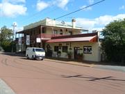
9 Jones St Gingin
Gingin
Avon Arc
Constructed from 1902 to 1903
| Type | Status | Date | Documents |
|---|---|---|---|
| Heritage List | Adopted | 17 Oct 2017 |
| Type | Status | Date | Documents |
|---|---|---|---|
| (no listings) |
| Type | Status | Date | Grading/Management | |
|---|---|---|---|---|
| Category | ||||
| Statewide Hotel Survey | Completed | 01 Nov 1997 | ||
| Municipal Inventory | Adopted | 17 Oct 2017 | ||
Substantial additions and internal modifications over time. Recent limited internal renovations.
Individual Building or Group
| Epoch | General | Specific |
|---|---|---|
| Present Use | COMMERCIAL | Hotel, Tavern or Inn |
| Original Use | COMMERCIAL | Hotel, Tavern or Inn |
| Style |
|---|
| Federation Filigree |
| Type | General | Specific |
|---|---|---|
| Roof | METAL | Corrugated Iron |
| Wall | TIMBER | Other Timber |
| Wall | BRICK | Other Brick |
| General | Specific |
|---|---|
| OCCUPATIONS | Hospitality industry & tourism |
| SOCIAL & CIVIC ACTIVITIES | Sport, recreation & entertainment |
This information is provided voluntarily as a public service. The information provided is made available in good faith and is derived from sources believed to be reliable and accurate. However, the information is provided solely on the basis that readers will be responsible for making their own assessment of the matters discussed herein and are advised to verify all relevant representations, statements and information.
Constructed from 1902, Constructed from 1903
Gingin Hotel is the only surviving Hotel in Gingin and has operated continually since it opened in 1903. It is a fine representative example of the Federation period of architecture and of development in Gingin at that time, making a significant contribution to the townscape heritage. It is also significant for associations with various owners and managers including John Musk, and wife Catherine, Tom Jones, and others, and demonstrates a sense of place for the social and hospitality functions of the place, that continue in the 21st century,
The hotel faces Jones Street directly opposite Gingin Railway Station. The two-storey building has a simple parapet with pilastered bays and an asymmetrical pediment detail with a bay identifying the main entry. Verandas at ground floor and first floor levels extend across the front and down the east side. There is a c.1960s single storey addition along the east side.
The railway opened from Midland to Ging in in 1891 and continued through to Mogumber in 1892 and then beyond to Geraldton. By 1902, the town was developing rapidly and the Gingin Hotel was constructed directly opposite the railway station providing a distinct advantage over the Granville Hotel. It opened on 29 January 1903. Rumour has it that two defrocked priests (Fathers Duff and Flood) were the responsible. The original licensee was Mrs Catherine Malone, with her brother Patrick Murphy taking over after her sudden death in 1905. The Granville Hotel still had the business of proving refreshments for the train railway patrons. However new management in 1908 at Gingin Hotel, William Spence (from Miners Arms in Northampton) rivalled that business. In the mid 19210, the wealthy northwest pastoralist John Musk purchased the hotel, in order to replace the lessee at the time with JVA Jones' son Tom as Manager, after he had returned from World War One. After John Musk's death in 1921, his wife Catherine took over his estate. The trains continued to provide hotel patronage for refreshments and accommodation until the mid 1940s, although railway patronage diminished after that time.
Integrity: Moderate degree Authenticity: Moderate degree
Good
This information is provided voluntarily as a public service. The information provided is made available in good faith and is derived from sources believed to be reliable and accurate. However, the information is provided solely on the basis that readers will be responsible for making their own assessment of the matters discussed herein and are advised to verify all relevant representations, statements and information.
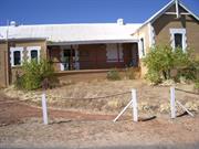
Lot 500 Jones St Gingin
Plan 66821
Gingin Railway Station and Quarters (fmr)
Gingin
Avon Arc
Constructed from 1892
| Type | Status | Date | Documents |
|---|---|---|---|
| Heritage List | Adopted | 17 Oct 2017 | |
| State Register | Registered | 02 Sep 2011 | HCWebsite.Listing+ListingDocument, HCWebsite.Listing+ListingDocument |
| Type | Status | Date | Documents |
|---|---|---|---|
| (no listings) |
| Type | Status | Date | Grading/Management | |
|---|---|---|---|---|
| Category | ||||
| Municipal Inventory | Adopted | 17 Oct 2017 | Category A | |
| Classified by the National Trust | Classified | 03 Jul 1978 | ||
| Statewide Railway Heritage Surve | Completed | 01 Aug 1994 | ||
| Register of the National Estate | Permanent | 28 Sep 1982 | ||
Gingin Railway Station & Quarters is in excellent condition. However, it is feared that its current abandoned state could lead to damage from white ants and general neglect (2010).
| Library Id | Title | Medium | Year Of Publication |
|---|---|---|---|
| 12051 | Gingin Railway Station and Quarters: Lot 500 Jones Street, Gingin | Heritage Study {Cons'n Plan} | 2013 |
| 523 | Restoration of the iron roof of the Gingin railway station | Heritage Study {Other} | 1994 |
Individual Building or Group
| Epoch | General | Specific |
|---|---|---|
| Original Use | Transport\Communications | Rail: Railway Station |
| Present Use | VACANT\UNUSED | Vacant\Unused |
| Style |
|---|
| Victorian Georgian |
| Vernacular |
| Type | General | Specific |
|---|---|---|
| Roof | METAL | Corrugated Iron |
| Wall | BRICK | Face Brick |
| General | Specific |
|---|---|
| OUTSIDE INFLUENCES | Water, power, major t'port routes |
| TRANSPORT & COMMUNICATIONS | Rail & light rail transport |
| DEMOGRAPHIC SETTLEMENT & MOBILITY | Settlements |
This information is provided voluntarily as a public service. The information provided is made available in good faith and is derived from sources believed to be reliable and accurate. However, the information is provided solely on the basis that readers will be responsible for making their own assessment of the matters discussed herein and are advised to verify all relevant representations, statements and information.
Opened for passengers and goods 19 May 1891. The refreshment rooms, goods shed, crane and portion of the platform have already been demolished, but the main station building is still intact and marks one of the most significant events in the district's history.
This Excellent example of railway building is of brick and render. It has interesting iron trusses on the verandah and slightly bow windows set in square frames. The building is in good repair and is still used as a railway station. Neat brick building, painted white with iron roof. Two wings separated by waiting shelter. Two chimneys, sash windows of two panes, panelled doors - two large (illegible). The station is situated opposite the Gingin hotel.
Assessment 1978 Built for the Midland Railway c. 1891 The first Civil Engineer of the Railway Company was Mr Frank Stafford The Railway Construction Contractor was Edward Vivian Harvey Keane One of the first railway stations built by the Midland Railway Company for its new line from Midland Junction. The line to Gingin was opened for traffic by Sir William Robinson in April 1891.
This information is provided voluntarily as a public service. The information provided is made available in good faith and is derived from sources believed to be reliable and accurate. However, the information is provided solely on the basis that readers will be responsible for making their own assessment of the matters discussed herein and are advised to verify all relevant representations, statements and information.
Constructed from 1891
Gingin Railway Station & Quarters was one of the first railway stations constructed on the Midland Junction to Walkway line by the Midland Railway Company. It was constructed by prominent builder, innovative farmer and developer Friedrich Wilhelm Gustav Liebe, and is also associated with Edward Keane, a leading railway builder. It was part of the development of the Midland-Walkaway Railway that provided the essential transport for pastoral and agricultural development in the region.
The "T" shape form comprises an extensive 'frontage along the platform parallel with the railways line, and protruding gable street frontage to Jones Street. The pavilion gable roof similarly runs parallel with the railway line with gables each end and a gable feature on the street front. All other railway elements associated with the site are no longer extant.
Gingin Railway Station was constructed in 1891 by the Midland Railway Company, under Edward Keane's direction as he extended the railway line from Midland Junction through to Walkway and later to Geraldton, opening up the pastoral and agricultural land and development opportunities. The Jones family of nearby Granville ran the refreshments rooms. The railway station comprised a goods shed, refreshment rooms and a longer platform, water tanks at each end to facilitate two trains at simultaneously, and crane, all that have since been demolished. With the demise of steam trains, and later the introduction of more efficient road transport, the railway station was decommissioned in 1976. Sometime later after it had been vacant and fallen into disrepair, It was leased to the Diggins family for 21 years during which time they restored the place. The Gingin Railway Station building is now owned by the National Trust. This place is currently leased to the Gingin Lions club who have undertaken conservation work to the building and have opened to the public as a small cafe, gift shop and interpretive centre.
Integrity : Moderate degree Authenticity : Moderate degree
Very Good
| Owner | Category |
|---|---|
| R.V. & P. Diggins | Other Private |
This information is provided voluntarily as a public service. The information provided is made available in good faith and is derived from sources believed to be reliable and accurate. However, the information is provided solely on the basis that readers will be responsible for making their own assessment of the matters discussed herein and are advised to verify all relevant representations, statements and information.
10 Lefroy St Gingin
Mrs Bandy's House
Mrs Kings House
Gingin
Avon Arc
Constructed from 1904
| Type | Status | Date | Documents |
|---|---|---|---|
| (no listings) |
| Type | Status | Date | Documents |
|---|---|---|---|
| (no listings) |
| Type | Status | Date | Grading/Management | |
|---|---|---|---|---|
| Category | ||||
| Municipal Inventory | Adopted | 18 Oct 2005 | Category C | |
Individual Building or Group
| Epoch | General | Specific |
|---|---|---|
| Present Use | RESIDENTIAL | Single storey residence |
| Original Use | RESIDENTIAL | Single storey residence |
| Other Use | HEALTH | Hospital |
| Type | General | Specific |
|---|---|---|
| Wall | BRICK | Other Brick |
| Roof | METAL | Corrugated Iron |
| General | Specific |
|---|---|
| SOCIAL & CIVIC ACTIVITIES | Community services & utilities |
| DEMOGRAPHIC SETTLEMENT & MOBILITY | Settlements |
This information is provided voluntarily as a public service. The information provided is made available in good faith and is derived from sources believed to be reliable and accurate. However, the information is provided solely on the basis that readers will be responsible for making their own assessment of the matters discussed herein and are advised to verify all relevant representations, statements and information.
Constructed from 1904
Important because the house served as an unofficial hospital.
Originally a four roomed house with a passage down the centre. The rooms were approximately 14ft square with high ceilings. The front bedroom had a pressed tin ceiling, as has the front half of the passage. The living room behind has a corrugated tin ceiling and a burnt brick fireplace. The other rooms may not have had ceilings originally, now they are asbestos or similar. The front door and windows are original and the interior of this part of the house is probably original.The verandahs have been concreted with steel verandah posts. The kitchen is relatively new and the levels at the back have been raised to correspond with the rest of the house. Originally, high and steep steps made it dangerous.
The original owner, Hugh S. King, was a son of Daniel King of the Junction. At one time he was the town's Undertaker. His wife, Lily King, served for many years as the town Nurse and this house became the Hospital with many babies being born here. Numerous Gingin residents owe their lives to Mrs. King.
| Ref ID No | Ref Name | Ref Source | Ref Date |
|---|---|---|---|
| H Udell: "History of Gingin". |
This information is provided voluntarily as a public service. The information provided is made available in good faith and is derived from sources believed to be reliable and accurate. However, the information is provided solely on the basis that readers will be responsible for making their own assessment of the matters discussed herein and are advised to verify all relevant representations, statements and information.
2-4 Lefroy St Gingin
Horan's House
Gingin
Avon Arc
Constructed from 1911
| Type | Status | Date | Documents |
|---|---|---|---|
| (no listings) |
| Type | Status | Date | Documents |
|---|---|---|---|
| (no listings) |
| Type | Status | Date | Grading/Management | |
|---|---|---|---|---|
| Category | ||||
| Municipal Inventory | Adopted | 18 Oct 2005 | Category C | |
Very poor
Individual Building or Group
| Epoch | General | Specific |
|---|---|---|
| Original Use | RESIDENTIAL | Single storey residence |
| Type | General | Specific |
|---|---|---|
| Wall | ASBESTOS | Other Asbestos |
| Wall | TIMBER | Weatherboard |
| Wall | EARTH | Adobe {Mud Brick} |
| Roof | TIMBER | Other Timber |
| General | Specific |
|---|---|
| DEMOGRAPHIC SETTLEMENT & MOBILITY | Settlements |
| TRANSPORT & COMMUNICATIONS | Rail & light rail transport |
This information is provided voluntarily as a public service. The information provided is made available in good faith and is derived from sources believed to be reliable and accurate. However, the information is provided solely on the basis that readers will be responsible for making their own assessment of the matters discussed herein and are advised to verify all relevant representations, statements and information.
Constructed from 1911
The house had three rooms with wooden board ceilings. The kitchen, bathroom and toilet were added on in asbestos and weather board later. An old laundry with a copper (which has since been removed) stood just at the rear. These additions are now largely destroyed. The central room still has an old Metters stove. The walls are in good condition but the bull nose iron on the front verandah is partly collapsed. Plants in the house garden include large oak and carob trees, very old jade plants, climbing rose, English may, honeysuckle and fruit trees.
The existing house was built by Mr. W.H.J. Horan (Station Master, Gingin) in 1911. His sons Clayton and Eric helped him. The clay for the mud bats was dug on the property closer to the Brook and the excavation can still be seen. William H.J. Horan was appointed Station Master at Gingin in 1901. With his wife and their five children, Eric, Clayton, Eileen, Leonie and Lillian, he lived in the Railway Station quarters for many years. He retired from the railways and built a house on The Horseshoe and lived the rest of his days here. He was employed as Roads Board Secretary from 1925 until his death in 1937. His son, Eric, was killed in a horse riding accident on Christmas Day, 1911 while the house was being built. Lillian Horan served as Roads Board Secretary from 1937 until her sudden death while at work in the Road Board Office in 1948. Lillian and her sister Eileen lived in the house in Lefroy St while their other sister Leonie married Elvie King.
Very Poor
| Ref ID No | Ref Name | Ref Source | Ref Date |
|---|---|---|---|
| H Udell: "History of Gingin". |
This information is provided voluntarily as a public service. The information provided is made available in good faith and is derived from sources believed to be reliable and accurate. However, the information is provided solely on the basis that readers will be responsible for making their own assessment of the matters discussed herein and are advised to verify all relevant representations, statements and information.
36 Lefroy St Gingin
Gingin
Avon Arc
Constructed from 1910
| Type | Status | Date | Documents |
|---|---|---|---|
| (no listings) |
| Type | Status | Date | Documents |
|---|---|---|---|
| (no listings) |
| Type | Status | Date | Grading/Management | |
|---|---|---|---|---|
| Category | ||||
| Classified by the National Trust | Recorded | 03 Jul 1978 | ||
Individual Building or Group
| Epoch | General | Specific |
|---|---|---|
| Present Use | RESIDENTIAL | Single storey residence |
| Original Use | RESIDENTIAL | Single storey residence |
This information is provided voluntarily as a public service. The information provided is made available in good faith and is derived from sources believed to be reliable and accurate. However, the information is provided solely on the basis that readers will be responsible for making their own assessment of the matters discussed herein and are advised to verify all relevant representations, statements and information.
38 Lefroy St Gingin
Aldershot
Roselea or Roseneal
Gingin
Avon Arc
Constructed from 1904
| Type | Status | Date | Documents |
|---|---|---|---|
| (no listings) |
| Type | Status | Date | Documents |
|---|---|---|---|
| (no listings) |
| Type | Status | Date | Grading/Management | |
|---|---|---|---|---|
| Category | ||||
| Municipal Inventory | Adopted | 17 Nov 1994 | Category C | |
Individual Building or Group
| Epoch | General | Specific |
|---|---|---|
| Original Use | RESIDENTIAL | Single storey residence |
| Present Use | RESIDENTIAL | Single storey residence |
| Type | General | Specific |
|---|---|---|
| Roof | METAL | Corrugated Iron |
| Wall | STONE | Local Stone |
| Wall | EARTH | Adobe {Mud Brick} |
This information is provided voluntarily as a public service. The information provided is made available in good faith and is derived from sources believed to be reliable and accurate. However, the information is provided solely on the basis that readers will be responsible for making their own assessment of the matters discussed herein and are advised to verify all relevant representations, statements and information.
Constructed from 1904
Mr Collett had a thriving orchard, irrigated from the brook. He also drove the hearse.
Four front rooms with a central passage are of Casuarina stone. Mud bat rooms at the rear were added later by Dick Masters. Since the renovations in 2007, there has been a second storey added. New ceilings, internal walls and electrical rewired. One of the existing bedrooms downstairs has been turned into a bathroom/laundry. Fireplaces remain in 3 of the rooms which have been upgraded aesthetically. Verandahs were upgraded and extended on east and west side of the house. There was an old stone walled building out the back (shed) that has been restored. A freestanding carport has been added. The property has a swimming pool and the property is now named "Robredeki". The owners have used materials to keep in with the heritage feel and look of the place.
This house was built for Robert Collett and family in about 1904. The property has had extensive renovations since ownership was taken over in 2007 by R & R Cooper.
| Ref ID No | Ref Name | Ref Source | Ref Date |
|---|---|---|---|
| H Udell: "History of Gingin". |
| Owner | Category |
|---|---|
| R & R Cooper | Other Private |
This information is provided voluntarily as a public service. The information provided is made available in good faith and is derived from sources believed to be reliable and accurate. However, the information is provided solely on the basis that readers will be responsible for making their own assessment of the matters discussed herein and are advised to verify all relevant representations, statements and information.
Lennards Brook Bridge Gingin
Gingin Abattoir
Gingin
Avon Arc
Constructed from 1855
| Type | Status | Date | Documents |
|---|---|---|---|
| (no listings) |
| Type | Status | Date | Documents |
|---|---|---|---|
| (no listings) |
| Type | Status | Date | Grading/Management | |
|---|---|---|---|---|
| Category | ||||
| Municipal Inventory | Adopted | 17 Nov 1994 | Category D | |
Site only
Individual Building or Group
| Epoch | General | Specific |
|---|---|---|
| Present Use | INDUSTRIAL\MANUFACTURING | Abbatoir |
| Original Use | COMMERCIAL | Hotel, Tavern or Inn |
| Other Use | FARMING\PASTORAL | Other |
| Type | General | Specific |
|---|---|---|
| Wall | EARTH | Pise {Rammed Earth} |
This information is provided voluntarily as a public service. The information provided is made available in good faith and is derived from sources believed to be reliable and accurate. However, the information is provided solely on the basis that readers will be responsible for making their own assessment of the matters discussed herein and are advised to verify all relevant representations, statements and information.
Constructed from 1855
No part of the building remains.
Richard Cockram and his family emigrated from England in 1850 and it is estimated that he came to Gingin with his brother-in-law, Thomas Buckingham, in 1854. They worked together to build pug walled houses and barns for Gingin settlers. Richard and his five sons lived and worked around Gingin though they had other interests in Perth and Wanneroo. The Cockram's built a two storey Hotel north of the Lennard's Brook crossing in the 1860's on the Gingin side of Lennard's Brook where the abattoir now stands Edmund Oxen Cockram, son of Richard, held a Publican's Licence in 1870 and the building was known as the Gingin Hotel The Hotel was partially destroyed by fire in 1886 and rebuilt as a single storey home by Ephraim Cockram and did not operate as a Hotel after this time. The property remained in the Cockram family until 1924 when it was sold to Thomas McCormick, then K Parsons, then to Mr. Harley. The roof blew off in a 1943 storm and a cottage was built nearby. Parsons removed the remaining mud bat and built a new brick and tile home near the site of the hotel. It is now owned by Mr N. Borrello who has constructed an extensive abattoir on the land
Site Only
| Ref ID No | Ref Name | Ref Source | Ref Date |
|---|---|---|---|
| H Udell: "History of Gingin". |
This information is provided voluntarily as a public service. The information provided is made available in good faith and is derived from sources believed to be reliable and accurate. However, the information is provided solely on the basis that readers will be responsible for making their own assessment of the matters discussed herein and are advised to verify all relevant representations, statements and information.
45 Lennards Rd Gingin
Gingin
Avon Arc
Constructed from 1860
| Type | Status | Date | Documents |
|---|---|---|---|
| (no listings) |
| Type | Status | Date | Documents |
|---|---|---|---|
| (no listings) |
| Type | Status | Date | Grading/Management | |
|---|---|---|---|---|
| Category | ||||
| Municipal Inventory | Adopted | 18 Oct 2005 | ||
Very poor.
Individual Building or Group
| Epoch | General | Specific |
|---|---|---|
| Original Use | FARMING\PASTORAL | Homestead |
| Present Use | FARMING\PASTORAL | Homestead |
| Type | General | Specific |
|---|---|---|
| Wall | EARTH | Adobe {Mud Brick} |
| Roof | TIMBER | Shingle |
| Roof | METAL | Corrugated Iron |
| General | Specific |
|---|---|
| OCCUPATIONS | Grazing, pastoralism & dairying |
| DEMOGRAPHIC SETTLEMENT & MOBILITY | Settlements |
This information is provided voluntarily as a public service. The information provided is made available in good faith and is derived from sources believed to be reliable and accurate. However, the information is provided solely on the basis that readers will be responsible for making their own assessment of the matters discussed herein and are advised to verify all relevant representations, statements and information.
Constructed from 1860
Built on the southern bank of Lennard's Brook by John York of Creaton for his son John York, Jnr. It was made from mud bat made from clay with a shingled roof, with three rooms and a verandah.
This house stands on the south side of Lennards Brook, just beyond the Ashby Bridge. Spratton was built by John York of Creaton for his son John York, Jnr. and his wife, Marion McHard who lived here in the 1860's and later moved to Breera. It was of mud bat made from the river clay with a shingled roof, colonial style with three rooms and a verandah. Four rooms were later added along the south side. John Dewar purchased Spratton in 1882 and after his death in 1911; John York ( J Y ) Dewar inherited it. In approximately 1938, J.Y. Dewar moved to Gingin and his son Leslie and his wife took over. Leslie demolished the old back section and two rooms, also of mud bat, were erected in their place raising the floor level to correspond with the rest of the house. Spratton was sold by the Dewar family in the 1980's and has since been unoccupied and largely overgrown.
Very Poor
| Ref ID No | Ref Name | Ref Source | Ref Date |
|---|---|---|---|
| H Udell: "History of Gingin". |
This information is provided voluntarily as a public service. The information provided is made available in good faith and is derived from sources believed to be reliable and accurate. However, the information is provided solely on the basis that readers will be responsible for making their own assessment of the matters discussed herein and are advised to verify all relevant representations, statements and information.
M1372 Mooliabeenee Rd Gingin
Gingin
Avon Arc
Constructed from 1943
| Type | Status | Date | Documents |
|---|---|---|---|
| (no listings) |
| Type | Status | Date | Documents |
|---|---|---|---|
| (no listings) |
| Type | Status | Date | Grading/Management | |
|---|---|---|---|---|
| Category | ||||
| Municipal Inventory | Adopted | 18 Oct 2005 | Category D | |
Historic Site
| Epoch | General | Specific |
|---|---|---|
| Original Use | MILITARY | Other |
| Type | General | Specific |
|---|---|---|
| Other | CONCRETE | Other Concrete |
| Other | STONE | Other Stone |
This information is provided voluntarily as a public service. The information provided is made available in good faith and is derived from sources believed to be reliable and accurate. However, the information is provided solely on the basis that readers will be responsible for making their own assessment of the matters discussed herein and are advised to verify all relevant representations, statements and information.
Constructed from 1943
An ironstone and mortar construction - circular with a base about 120cm in circumference and 40cm high with a smaller ring on top of it. Actual use uknown but built long before 1942.
Found when land was cleared mid 1990's. Soldiers camped nearby in 1942-44.
This information is provided voluntarily as a public service. The information provided is made available in good faith and is derived from sources believed to be reliable and accurate. However, the information is provided solely on the basis that readers will be responsible for making their own assessment of the matters discussed herein and are advised to verify all relevant representations, statements and information.
Mooliabeenee Rd Gingin
Gingin
Avon Arc
Constructed from 1891
| Type | Status | Date | Documents |
|---|---|---|---|
| (no listings) |
| Type | Status | Date | Documents |
|---|---|---|---|
| (no listings) |
| Type | Status | Date | Grading/Management | |
|---|---|---|---|---|
| Category | ||||
| Municipal Inventory | Adopted | 18 Oct 2005 | Category D | |
Other Built Type
| Epoch | General | Specific |
|---|---|---|
| Original Use | Transport\Communications | Rail: Housing or Quarters |
| Other Use | Transport\Communications | Comms: Post or Telegraph Office |
This information is provided voluntarily as a public service. The information provided is made available in good faith and is derived from sources believed to be reliable and accurate. However, the information is provided solely on the basis that readers will be responsible for making their own assessment of the matters discussed herein and are advised to verify all relevant representations, statements and information.
Constructed from 1891
No buildings exist there now.
The railway reached Mooliabeenie (presumably) soon after it reached Gingin in April 1891. A Station Master's house was built, which also served as a Post Office. Local settlers were employed on the railway and at the Station. The Ward family lived in a house to the west of the Station. After their departure during WW1, the house was used as a Shop and residence by Mr. W. Leaman. This was destroyed by fire in March 1922. Mr. J. O'Hare built a new house close to the Siding, which was still in operation c 1940. Yet another Store was built by Mr. Bill Read in 1946 when Mrs. Read resumed duties at the Railway Station and Post Office.
Site Only
This information is provided voluntarily as a public service. The information provided is made available in good faith and is derived from sources believed to be reliable and accurate. However, the information is provided solely on the basis that readers will be responsible for making their own assessment of the matters discussed herein and are advised to verify all relevant representations, statements and information.
Mooliabeenie Rd Gingin
Opposite P 17715 Cleaveland
Gingin
Avon Arc
| Type | Status | Date | Documents |
|---|---|---|---|
| (no listings) |
| Type | Status | Date | Documents |
|---|---|---|---|
| (no listings) |
| Type | Status | Date | Grading/Management | |
|---|---|---|---|---|
| Category | ||||
| Municipal Inventory | Adopted | 18 Oct 2005 | ||
Historic Site
| Epoch | General | Specific |
|---|---|---|
| Original Use | RESIDENTIAL | Single storey residence |
| Type | General | Specific |
|---|---|---|
| Wall | PLASTER | Other Plaster |
| Wall | EARTH | Adobe {Mud Brick} |
This information is provided voluntarily as a public service. The information provided is made available in good faith and is derived from sources believed to be reliable and accurate. However, the information is provided solely on the basis that readers will be responsible for making their own assessment of the matters discussed herein and are advised to verify all relevant representations, statements and information.
The house stood on the north side of Mooliabeenie Road, opposite the present day Cleveland homestead. The original house was built of mud bricks with three rooms in a row, plastered inside and out with lime mortar. On the western wall the fireplace stood, lined with burnt bricks. Later other rooms were added, built with yellow burnt bricks made from clay dug on the property It stood on an elevated terrace supported by an ironstone wall. There was also a well, lined with ironstone.
William Thomas King bought SL 444 of 75 acres in February of 1867. W.J. King married Selina Lazenby, a Gingin school teacher, in 1865. There were ten children born here. Ernest Hugh King bought Cleveland from his father in 1896 for 2,000 pounds. In 1905 it was sold to C.H. Teague from Subiaco for 1,138 pounds. Then in 1907, the property was sold to John Musk who built a new home on the south side of Mooliabeenie Road. The original Cleveland house was badly damaged by a storm in 1944.
Site Only
| Ref ID No | Ref Name | Ref Source | Ref Date |
|---|---|---|---|
| H Udell: "History of Gingin". |
This information is provided voluntarily as a public service. The information provided is made available in good faith and is derived from sources believed to be reliable and accurate. However, the information is provided solely on the basis that readers will be responsible for making their own assessment of the matters discussed herein and are advised to verify all relevant representations, statements and information.
Lot 12 Mooliabeenie Rd Gingin
Gingin
Avon Arc
Constructed from 1908
| Type | Status | Date | Documents |
|---|---|---|---|
| Heritage List | Adopted | 17 Oct 2017 |
| Type | Status | Date | Documents |
|---|---|---|---|
| (no listings) |
| Type | Status | Date | Grading/Management | |
|---|---|---|---|---|
| Category | ||||
| Municipal Inventory | Adopted | 17 Oct 2017 | Category C | |
Good
Individual Building or Group
| Epoch | General | Specific |
|---|---|---|
| Original Use | FARMING\PASTORAL | Homestead |
| Other Use | HEALTH | Hospital |
| Type | General | Specific |
|---|---|---|
| Roof | METAL | Wrought Iron |
| Wall | EARTH | Adobe {Mud Brick} |
| General | Specific |
|---|---|
| DEMOGRAPHIC SETTLEMENT & MOBILITY | Settlements |
| OCCUPATIONS | Grazing, pastoralism & dairying |
| OUTSIDE INFLUENCES | World Wars & other wars |
This information is provided voluntarily as a public service. The information provided is made available in good faith and is derived from sources believed to be reliable and accurate. However, the information is provided solely on the basis that readers will be responsible for making their own assessment of the matters discussed herein and are advised to verify all relevant representations, statements and information.
Constructed from 1908
Cleveland is significant as the site of the original c.1867 homestead built by William Thomas king, providing a home for his wife and family of ten children, demonstrating a way of life and associations with an early settler. Associations with John Musk who constructed the existing Cleveland in c.1907, that his wife Catherine Musk inherited in 1921 are significant. Mrs Musk was a philanthropic identity in the Gingin area, and Cleveland represents a fine example of the period and the Musk association. The World War Two association as or being utilised as a Military Hospital is significant.
The site of the original homestead is on the north side of Mooliabeenie Road opposite the existing Cleveland. The original house was built of mud bricks plastered with lime mortar, with three rooms in a row. On the west wall was a fireplace lined with burnt bricks. Later other rooms were added, built with yellow burnt bricks made from clay dug on the property It stood on an elevated terrace supported by an ironstone wall. There was also a well, lined with ironstone. It was severely damaged in 1944- ruins remain? No inspection of Cleveland in 2016.
William Thomas King bought Swan location 444 of 75 acres in February of 1867. He married Selina Lazenby, a Gingin school teacher, in 1865. There were ten children born here. In 1896 Ernest Hugh King bought Cleveland from his father for 2,000 pounds. In 1905 it was sold to C.H. Teague from Subiaco for 1,138 pounds. Then in 1907, the property was sold to John Musk who built a new home on the south side of Mooliabeenie Road. The original Cleveland house was badly damaged by a storm in 1944. John Musk, a wealthy grazier from the northwest ofW.A bought the property in 1907 and employed Jack Meakins and Bob Collett to make the mud bats. This large house was built with wide verandahs overlooking the Moondah Valley. John Musk died in 1921 and his wife Catherine, who also largely financed Boys' Town at Bindoon, inherited the property. The farm was sold in the 1930's to the Petersons of Northam and then to Les Payne in 1952. It was taken over as a Military Hospital during the Second World War. Mr. M. Williamson and T.M. Watson bought the house and renovated it in 1969. It was then purchased by Charles Turner in 1975 and lived in by members of the Turner family who stilled owned it in 2005.
| Ref ID No | Ref Name | Ref Source | Ref Date |
|---|---|---|---|
| H Udell: "History of Gingin". |
This information is provided voluntarily as a public service. The information provided is made available in good faith and is derived from sources believed to be reliable and accurate. However, the information is provided solely on the basis that readers will be responsible for making their own assessment of the matters discussed herein and are advised to verify all relevant representations, statements and information.
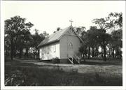
14 Robinson St Gingin
Gingin
Avon Arc
Constructed from 1931
| Type | Status | Date | Documents |
|---|---|---|---|
| Heritage List | Adopted | 17 Oct 2017 |
| Type | Status | Date | Documents |
|---|---|---|---|
| (no listings) |
| Type | Status | Date | Grading/Management | |
|---|---|---|---|---|
| Category | ||||
| Municipal Inventory | Adopted | 17 Oct 2017 | Category B | |
| Catholic Church Inventory | YES | 01 Jul 1998 | ||
| Classified by the National Trust | Recorded | 03 Jul 1978 | ||
Very good
Individual Building or Group
| Epoch | General | Specific |
|---|---|---|
| Original Use | RELIGIOUS | Church, Cathedral or Chapel |
| Present Use | RELIGIOUS | Church, Cathedral or Chapel |
| Style |
|---|
| Inter-War Gothic |
| Type | General | Specific |
|---|---|---|
| Wall | METAL | Other Metal |
| Roof | METAL | Corrugated Iron |
This information is provided voluntarily as a public service. The information provided is made available in good faith and is derived from sources believed to be reliable and accurate. However, the information is provided solely on the basis that readers will be responsible for making their own assessment of the matters discussed herein and are advised to verify all relevant representations, statements and information.
Constructed from 1931
St Catherines Roman Catholic Church is of significance for the associations with generations of the Catholic community in the Gingin area, Mrs Musk, and the New Norcia priests. The Church has social and religious significance for the events that have taken place that also evoke a sense of place.
The Church is a simple rectangular form with an entry porch at the elevated end of the building, with a ramped access returning down the side of the church. The roof is a steep pitch gable with a shadow half -timbered detail at the front with a simple cross above. The porch has a simple gable of same degree. The windows and double front doors are detailed with Gothic arches. The timber framed bell tower is located next to the entry porch with a small gable roof and cross atop the structure. The stone grotto is close-by. It is fenced. There is a steel framed and clad detached building in close proximity.
In 1891, the Governor set aside lots 2 and 3 for the Roman Catholic community for a chapel, glebe and cemetery. The church was not built until 1931, with 2/3 of the costs donated by Mrs Catherine Musk. Other elements were donated by Catholic community members. The Church was consecrated on 14 June 1931, and named St Catherine's in honour of Mrs Musk. A priest from New Norcia gave services until 1952. When it came under the jurisdiction of the Franciscan fathers of Midland.
Integrity: High degree Authenticity: Moderate/high degree
Good
| Owner | Category |
|---|---|
| Roman Catholic Diocese | Local Gov't |
This information is provided voluntarily as a public service. The information provided is made available in good faith and is derived from sources believed to be reliable and accurate. However, the information is provided solely on the basis that readers will be responsible for making their own assessment of the matters discussed herein and are advised to verify all relevant representations, statements and information.
Roe St Gingin
Stock Route Bridge
Gingin
Avon Arc
Constructed from 1906
| Type | Status | Date | Documents |
|---|---|---|---|
| (no listings) |
| Type | Status | Date | Documents |
|---|---|---|---|
| (no listings) |
| Type | Status | Date | Grading/Management | |
|---|---|---|---|---|
| Category | ||||
| Municipal Inventory | Adopted | 17 Nov 1994 | Category D | |
Historic site
| Epoch | General | Specific |
|---|---|---|
| Original Use | Transport\Communications | Road: Bridge |
| Other Use | SOCIAL\RECREATIONAL | Other |
| Present Use | Transport\Communications | Road: Bridge |
| Type | General | Specific |
|---|---|---|
| Other | TIMBER | Other Timber |
| General | Specific |
|---|---|
| DEMOGRAPHIC SETTLEMENT & MOBILITY | Settlements |
| TRANSPORT & COMMUNICATIONS | Droving |
| OCCUPATIONS | Grazing, pastoralism & dairying |
This information is provided voluntarily as a public service. The information provided is made available in good faith and is derived from sources believed to be reliable and accurate. However, the information is provided solely on the basis that readers will be responsible for making their own assessment of the matters discussed herein and are advised to verify all relevant representations, statements and information.
Constructed from 1906
Built in about 1906 to facilitate the movement of stock from north of the Gingin Brook to the Railway Station. A Stock Route was fenced from G. Sadler's land to connect (via the bridge) with Roe Street and across Jones Street to stock yards at the Railway Station.
Situated about 750m downstream from the Gingin Town bridge.
The Three Bridges and Stock Route, which connects Roe St and Dewar Rd, was constructed about 1906 to facilitate the movement of stock from northern farming properties to the Railway Station. Townspeople had objected to herds of cattle destroying and fouling the main street of the Town and damaging the Town bridge. In the 1930's the Stock Route and bridge were also used for carting lime from One Tree Hill to the Station. The Stock Route was fenced from G. Sadler's land and the bridging of the Brook, necessitating the crossing of three separate streams of Gingin Brook. The bridges were repaired between 1935 in 1938 using timber from the old Cowalla Bridge. George Hill was the contractor and the cost was 6 pounds. The Gingin Shire carried out a major renovation in 2000, which made it a beautiful place from which to view the Brook and its vegetation. A disastrous fire on 20 December 2002 burnt the Brook from a kilometre south of the Brand Highway up to the Park near Weld St in the Town. Two of the three bridges were also destroyed.
Site Only
| Ref ID No | Ref Name | Ref Source | Ref Date |
|---|---|---|---|
| H Udell: "History of Gingin". |
This information is provided voluntarily as a public service. The information provided is made available in good faith and is derived from sources believed to be reliable and accurate. However, the information is provided solely on the basis that readers will be responsible for making their own assessment of the matters discussed herein and are advised to verify all relevant representations, statements and information.
SL 370 Rural location - not accessible Gingin
Gingin
Avon Arc
| Type | Status | Date | Documents |
|---|---|---|---|
| (no listings) |
| Type | Status | Date | Documents |
|---|---|---|---|
| (no listings) |
| Type | Status | Date | Grading/Management | |
|---|---|---|---|---|
| Category | ||||
| Municipal Inventory | Adopted | 18 Oct 2005 | ||
Historic Site
| Epoch | General | Specific |
|---|---|---|
| Original Use | MINING | Other |
| Original Use | FARMING\PASTORAL | Other |
| General | Specific |
|---|---|
| DEMOGRAPHIC SETTLEMENT & MOBILITY | Settlements |
| OCCUPATIONS | Mining {incl. mineral processing} |
| PEOPLE | Early settlers |
| DEMOGRAPHIC SETTLEMENT & MOBILITY | Resource exploitation & depletion |
This information is provided voluntarily as a public service. The information provided is made available in good faith and is derived from sources believed to be reliable and accurate. However, the information is provided solely on the basis that readers will be responsible for making their own assessment of the matters discussed herein and are advised to verify all relevant representations, statements and information.
The Quarry (and others yet to be located) was an important source of easily worked stone when settlement of the Gingin Town site was in its early stages.
Hearsay evidence tells that the site was used as the source of stone for St Luke's Church and Philbeys Cottage Recent identification of a Quarry on SL 370 matches recorded descriptions of such a location but evidence is circumstantial unless testing of stone in that location and relevant buildings can be carried out. The origin of the term 'Casuarina' is unknown.
Site Only
| Ref ID No | Ref Name | Ref Source | Ref Date |
|---|---|---|---|
| H Udell: "History of Gingin". |
This information is provided voluntarily as a public service. The information provided is made available in good faith and is derived from sources believed to be reliable and accurate. However, the information is provided solely on the basis that readers will be responsible for making their own assessment of the matters discussed herein and are advised to verify all relevant representations, statements and information.
SL 551, Moore River Rd Gingin
Dooling's Ford
Gingin
Avon Arc
Constructed from 1907
| Type | Status | Date | Documents |
|---|---|---|---|
| (no listings) |
| Type | Status | Date | Documents |
|---|---|---|---|
| RHP - Does not warrant assessment | Current | 30 Aug 2019 |
| Type | Status | Date | Grading/Management | |
|---|---|---|---|---|
| Category | ||||
| Municipal Inventory | Adopted | 18 Oct 2005 | Category C | |
Historic site
| Epoch | General | Specific |
|---|---|---|
| Original Use | Transport\Communications | Road: Bridge |
This information is provided voluntarily as a public service. The information provided is made available in good faith and is derived from sources believed to be reliable and accurate. However, the information is provided solely on the basis that readers will be responsible for making their own assessment of the matters discussed herein and are advised to verify all relevant representations, statements and information.
Constructed from 1907
It is of historical interest as important to local communications and the settlements nearby.
It has now been bypassed by the Moore River Road and a more recent bridge. It had three sections, each crossing a stream of the Gingin Brook. One bridge has collapsed; the other two are not totally safe. The land on which it stands is now under private ownership.
This is a substantial bridge built in 1907 by Christopher Hough. He was both contractor and builder. This was the only bridge crossing of the Gingin Brook between Gingin and the coastal areas and served for many years.
This information is provided voluntarily as a public service. The information provided is made available in good faith and is derived from sources believed to be reliable and accurate. However, the information is provided solely on the basis that readers will be responsible for making their own assessment of the matters discussed herein and are advised to verify all relevant representations, statements and information.
Wannamal South Rd Gingin
Gingin
Avon Arc
| Type | Status | Date | Documents |
|---|---|---|---|
| (no listings) |
| Type | Status | Date | Documents |
|---|---|---|---|
| (no listings) |
| Type | Status | Date | Grading/Management | |
|---|---|---|---|---|
| Category | ||||
| Register of the National Estate | Registered | 28 Sep 1982 | ||
Historic site
| Epoch | General | Specific |
|---|---|---|
| Original Use | PARK\RESERVE | Park\Reserve |
| Original Use | FORESTRY | Timber Mill |
| Type | General | Specific |
|---|---|---|
| Other | TIMBER | Log |
| General | Specific |
|---|---|
| OCCUPATIONS | Timber industry |
This information is provided voluntarily as a public service. The information provided is made available in good faith and is derived from sources believed to be reliable and accurate. However, the information is provided solely on the basis that readers will be responsible for making their own assessment of the matters discussed herein and are advised to verify all relevant representations, statements and information.
Weld St Gingin
Gingin Cricket Ground
Gingin
Avon Arc
| Type | Status | Date | Documents |
|---|---|---|---|
| (no listings) |
| Type | Status | Date | Documents |
|---|---|---|---|
| (no listings) |
| Type | Status | Date | Grading/Management | |
|---|---|---|---|---|
| Category | ||||
| Municipal Inventory | Adopted | 18 Oct 2005 | Category D | |
Excellent
Urban Open Space
| Epoch | General | Specific |
|---|---|---|
| Original Use | PARK\RESERVE | Park\Reserve |
This information is provided voluntarily as a public service. The information provided is made available in good faith and is derived from sources believed to be reliable and accurate. However, the information is provided solely on the basis that readers will be responsible for making their own assessment of the matters discussed herein and are advised to verify all relevant representations, statements and information.
he Oval, as a place for recreation, has always occupied the same site being gradually improved by levelling and the construction of facilities. It was originally known as the Gingin Cricket Ground (c1900) and by 1908 had a good concrete cricket pitch. Railway excursions from Perth brought picnickers to enjoy themselves on the Oval. In 1964, the Oval was levelled and seeded and on the 21st of November that year, change rooms and a tea shed were opened. A large modem hall was erected in the early 1980's which caters for badminton, indoor cricket and other recreational activities having a kitchen and supper room, toilets and change rooms. A public swimming pool has been constructed to the south side which shares these amenities.
Excellent
This information is provided voluntarily as a public service. The information provided is made available in good faith and is derived from sources believed to be reliable and accurate. However, the information is provided solely on the basis that readers will be responsible for making their own assessment of the matters discussed herein and are advised to verify all relevant representations, statements and information.
Weld St Gingin
Gingin
Avon Arc
Constructed from 1976
| Type | Status | Date | Documents |
|---|---|---|---|
| (no listings) |
| Type | Status | Date | Documents |
|---|---|---|---|
| RHP - Does not warrant assessment | Current | 30 Aug 2019 |
| Type | Status | Date | Grading/Management | |
|---|---|---|---|---|
| Category | ||||
| Municipal Inventory | Adopted | 18 Oct 2005 | Category D | |
Urban Park
| Epoch | General | Specific |
|---|---|---|
| Original Use | PARK\RESERVE | Park\Reserve |
This information is provided voluntarily as a public service. The information provided is made available in good faith and is derived from sources believed to be reliable and accurate. However, the information is provided solely on the basis that readers will be responsible for making their own assessment of the matters discussed herein and are advised to verify all relevant representations, statements and information.
Constructed from 1976
A central focus for tourists and historical displays.
The Gingin Brook immediately below the town bridge was partly closed and developed as a scenic pool with a weir to control the water level. Land around was grassed and barbeques and children's swings etc were installed This facility was officially opened on 17th April 1976. Water Wheel - the metal machinery and axle from the old wooden water wheel on Cheriton was brought to Granville Park and Mr. Frank Butler constructed a replica water wheel. The Shire constructed a water race and this remarkable wheel was installed. It turns constantly, demonstrating the enormous strength of this ancient form of power. The pump, which is driven by the water wheel, was designed and installed by Neil Butcher in 1984. It operates the fountain on the lily pond. Cheriton Arch - by 1978, all that remained of the home of W.L. Brockman of Cheriton was a stone arch, originally protecting the front door of the house. It was deteriorating quickly so the remaining limestone blocks were removed to the Park. On a site just to the north of the Granville Arts Centre, Mr. Paul Butler rebuilt the arch using as much of the original blocks as possible plus that which he shaped himself from local limestone. Pioneer Pavilion - the Pioneer Pavilion combines facilities for travellers with the commemoration of eariy settlers. It was opened on the 23rd April 2001.
This information is provided voluntarily as a public service. The information provided is made available in good faith and is derived from sources believed to be reliable and accurate. However, the information is provided solely on the basis that readers will be responsible for making their own assessment of the matters discussed herein and are advised to verify all relevant representations, statements and information.
Weld St Gingin
Sadler's Home - Granville
Gingin
Avon Arc
Constructed from 1880
| Type | Status | Date | Documents |
|---|---|---|---|
| (no listings) |
| Type | Status | Date | Documents |
|---|---|---|---|
| (no listings) |
| Type | Status | Date | Grading/Management | |
|---|---|---|---|---|
| Category | ||||
| Municipal Inventory | Adopted | 18 Oct 2005 | ||
Fair
Other Built Type
| Epoch | General | Specific |
|---|---|---|
| Present Use | FARMING\PASTORAL | Other |
| Original Use | FARMING\PASTORAL | Other |
| Type | General | Specific |
|---|---|---|
| Roof | METAL | Corrugated Iron |
| Wall | STONE | Local Stone |
| General | Specific |
|---|---|
| DEMOGRAPHIC SETTLEMENT & MOBILITY | Settlements |
This information is provided voluntarily as a public service. The information provided is made available in good faith and is derived from sources believed to be reliable and accurate. However, the information is provided solely on the basis that readers will be responsible for making their own assessment of the matters discussed herein and are advised to verify all relevant representations, statements and information.
Constructed from 1880
A historical home within the Gingin Township. It has connections with St Luke's Church.
A large house made of Casuarina Stone quarried nearby. Pit sawn timber held the iron roof. There are three central rooms with ceilings of pine boards, front and back verandahs and original detached kitchen. The kitchen is now on the back verandah with improvements to utility room at rear.
Rev. George Sadler built the house for rental purposes in the 1880's. It was rented as a residence by Rev Edward T. Pritchett c 1884 to 1893. Arthur Sadler, son of George, returned to live there in the 1920's and remained until his death c 1980 The property was inherited by grandson, Geoff Todman, and is now owned by J.Farrell.
| Ref ID No | Ref Name | Ref Source | Ref Date |
|---|---|---|---|
| H Udell: "History of Gingin". |
| Owner | Category |
|---|---|
| J.Farrell. | Other Private |
This information is provided voluntarily as a public service. The information provided is made available in good faith and is derived from sources believed to be reliable and accurate. However, the information is provided solely on the basis that readers will be responsible for making their own assessment of the matters discussed herein and are advised to verify all relevant representations, statements and information.
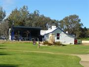
10 Weld St Gingin
Located in Granville Park Lot 262.
Granville (Jones) Hotel
Gingin
Avon Arc
Constructed from 1860 to 2009
| Type | Status | Date | Documents |
|---|---|---|---|
| Heritage List | Adopted | 17 Oct 2017 |
| Type | Status | Date | Documents |
|---|---|---|---|
| RHP - Assessed - Below Threshold | Current | 22 Feb 2013 |
| Type | Status | Date | Grading/Management | |
|---|---|---|---|---|
| Category | ||||
| Municipal Inventory | Adopted | 17 Oct 2017 | Category A | |
| Register of the National Estate | Permanent | 28 Sep 1982 | ||
| Statewide Hotel Survey | Completed | 01 Nov 1997 | ||
| Classified by the National Trust | Classified | 03 Jul 1978 | ||
Very good
| Library Id | Title | Medium | Year Of Publication |
|---|---|---|---|
| 3920 | Gingin Townscape Project | Report | 1991 |
| 2251 | A history of Gingin, 1830 to 1960. | Book | 1979 |
| 3864 | Statewide Survey of Hotels 1829-1939 Southern Region Western Australia. | Heritage Study {Other} | 1997 |
Individual Building or Group
| Epoch | General | Specific |
|---|---|---|
| Original Use | RESIDENTIAL | Single storey residence |
| Present Use | SOCIAL\RECREATIONAL | Other Community Hall\Centre |
| Original Use | COMMERCIAL | Hotel, Tavern or Inn |
| Style |
|---|
| Victorian Georgian |
| Type | General | Specific |
|---|---|---|
| Wall | BRICK | Face Brick |
| Roof | METAL | Corrugated Iron |
| General | Specific |
|---|---|
| OCCUPATIONS | Hospitality industry & tourism |
This information is provided voluntarily as a public service. The information provided is made available in good faith and is derived from sources believed to be reliable and accurate. However, the information is provided solely on the basis that readers will be responsible for making their own assessment of the matters discussed herein and are advised to verify all relevant representations, statements and information.
Constructed from 1860
Granville is a surviving example of the early development in Gingin townsite and associations with the community identity of the T J Jones and family, and the hospitality function of social significance and for the people who stayed there. The building set in the undulating grassed banks of Gingin Brook, featuring the water wheel, is a landmark in Gingin and makes a considerable contribution to the historic townscape.
The remaining building are likely remnants of the c.1860 and c.1971 buildings. Set in undulating park land sloping down to Gingin Brook to the north, the Weld Street frontage of the building has a gable wall and the expansive skillion shade structure. Behind that is the remainder of the "L" form plan. That evidences a gable to the north elevation with break pitch enclosure both sides.
Thomas James (T J) Jones lived in Weld Street and had Mr Cartmell build the hotel and residence over the road. South of the Gingin brook. The first structure was mudbat, two rooms facing Weld Street with services at the back and a cellar on the north side, operating as an inn and his residence. It is unsure if it was named Granville at that time. In 1869, the Government Gazette proclaimed the townsite named Granville, perhaps the Hotel was consequently so named. In December 1871, the town was proclaimed as Gingin. Jones had been pressured to construct an suitable building on the site as a condition of attaining the Inn keepers Licence in 1872. In c.1871 the southern wing comprising four large rooms was added, constructed in burnt bricks and corrugated iron. Liquor had been for sale for some time operating as the Granville Hotel (wayside inn). In 1885 T J Jones died and his son James Vigors Aldred (JVA) Jones took over with his wife Emma (Clinch). In 1893, (JVA) Jones was elected to the inaugural Gingin Road board (1893-1896, 1900-1901, 2001-2016, 2019,2020, 2023-2029) and the inaugural meeting was at the Granville Hotel. In c.1895 a detached brick and iron on the north side served as the kitchen, dining room and two bedrooms. On the south side of the brook was the orchard and vegetable garden that provided fresh produce to the hotel and Mrs Jones catering to the railway refreshment rooms. After JVA Jones death in 1929, the property was administered by WA trustees and sold over a number of years. The property change hands a few times until 1969 when the Gingin Shire purchased it, demolishing the north wing, and a rear veranda. The remainder was renovated as an Arts and Crafts Centre between 1978 and 2003. The Shire leases the building to the successful cafe operators. The Water wheel is a feature located at the edge of Gingin Brook that runs through Granville Park. A replica of the flour mill established at Cheriton Farm in 1855, the original axel was restored and relocated to this site by Frank Butler for the Shire in 1978. In 2012 members of Ginqin's Mens Shed rebuilt the timber section of the water wheel.
Integrity: High degree Authenticity: Low/moderate degree
Good
| Ref ID No | Ref Name | Ref Source | Ref Date |
|---|---|---|---|
| H Udell: "History of Gingin". p 154 & 276 |
| Owner | Category |
|---|---|
| Shire of Gingin | Local Gov't |
This information is provided voluntarily as a public service. The information provided is made available in good faith and is derived from sources believed to be reliable and accurate. However, the information is provided solely on the basis that readers will be responsible for making their own assessment of the matters discussed herein and are advised to verify all relevant representations, statements and information.
14 Weld St Gingin
Gingin Fuel Supply
Gingin
Avon Arc
Constructed from 1886
| Type | Status | Date | Documents |
|---|---|---|---|
| (no listings) |
| Type | Status | Date | Documents |
|---|---|---|---|
| (no listings) |
| Type | Status | Date | Grading/Management | |
|---|---|---|---|---|
| Category | ||||
| Statewide Hotel Survey | Adopted | |||
| Municipal Inventory | Adopted | 17 Nov 1994 | Category C | |
Good
Individual Building or Group
| Epoch | General | Specific |
|---|---|---|
| Present Use | COMMERCIAL | Hotel, Tavern or Inn |
| Other Use | Transport\Communications | Road: Other |
| Other Use | INDUSTRIAL\MANUFACTURING | Bakery |
| Original Use | RESIDENTIAL | Single storey residence |
| Other Use | COMMERCIAL | Shop\Retail Store {single} |
| Present Use | OTHER | Other |
| Original Use | COMMERCIAL | Hotel, Tavern or Inn |
| Type | General | Specific |
|---|---|---|
| Wall | BRICK | Other Brick |
| Wall | STONE | Other Stone |
| General | Specific |
|---|---|
| OCCUPATIONS | Rural industry & market gardening |
| DEMOGRAPHIC SETTLEMENT & MOBILITY | Land allocation & subdivision |
This information is provided voluntarily as a public service. The information provided is made available in good faith and is derived from sources believed to be reliable and accurate. However, the information is provided solely on the basis that readers will be responsible for making their own assessment of the matters discussed herein and are advised to verify all relevant representations, statements and information.
Constructed from 1886
Built by Reuben Edwards, a son-in-law of John Dewar. The top story was destroyed in a violent storm in 1943. It has since changed hands many times being used as a General Store, Bakery and in recent times for machinery and agriculture sales and a Petrol Station and Garage.
Built for Ruben Edwards and his wife Adeline Dewer, the two storey stone and mud bat building consisted of two sitting rooms, two bedrooms, dining room and bar and tap room. There was a cellar below the house, a scullery and outbuildings. Licensed as a Public House i 1905, the building has also been used as a Bakery and General Store. The place now functions as a garage and service station and consists of living quarters behind a Shop front and Service Station.
The Edwards Gingin Hotel was built for Reuben Edwards and his wife, Adeline Dewar, in anticipation of the railway passing through Gingin. The builder was Richard Masters and building commenced in May of 1886. It was a two storey stone and mud bat with two sitting rooms, two bedrooms, dining room, and bar and tap room. There was a cellar below the house, a scullery and outbuildings. It was licensed as a Public House in 1905. In July 1907, it was transferred to Clayton Edwards' son, Reuben, who converted it to a Bakery and General Store. In 1910 it was taken over by A. Lucraft, who did not use the Bakery. In December of 1914, a violent storm blew the roof off but this was replaced. In 1922 it was taken over by J.E. Prior. Between 1926 and 1939, it operated as a Bakery by H. White, F. Roberts, C P. Knight and E.G. Portwine for various amounts of time. When it was leased to Pearse Herbert in 1928, he installed a petrol pump on Weld St. In March 1943, the Hotel/Store was again unroofed by a storm and the top storey demolished. Ralph Hill re-roofed the lower stonewalls as a bungalow. The building has been extended to the front and north side and has served as a Garage and Service Station for many years. Peter Crowe is the present owner.
Good
| Ref ID No | Ref Name | Ref Source | Ref Date |
|---|---|---|---|
| H Udell: "History of Gingin". |
This information is provided voluntarily as a public service. The information provided is made available in good faith and is derived from sources believed to be reliable and accurate. However, the information is provided solely on the basis that readers will be responsible for making their own assessment of the matters discussed herein and are advised to verify all relevant representations, statements and information.
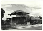
15 Weld St Gingin
Lot 29 facing Edwards Street.
Railway Hotel (fmr)
Gingin
Avon Arc
Constructed from 1870 to 1886
| Type | Status | Date | Documents |
|---|---|---|---|
| Heritage List | Adopted | 17 Oct 2017 | |
| State Register | Registered | 29 Sep 1998 | HCWebsite.Listing+ListingDocument, HCWebsite.Listing+ListingDocument |
| Type | Status | Date | Documents |
|---|---|---|---|
| (no listings) |
| Type | Status | Date | Grading/Management | |
|---|---|---|---|---|
| Category | ||||
| Register of the National Estate | Permanent | 21 Oct 1980 | ||
| Classified by the National Trust | Classified | 03 May 1977 | ||
| Statewide Hotel Survey | Completed | 01 Nov 1997 | ||
| Municipal Inventory | Adopted | 17 Oct 2017 | Category A | |
Very good
Individual Building or Group
| Epoch | General | Specific |
|---|---|---|
| Original Use | COMMERCIAL | Shop\Retail Store {single} |
| Present Use | RESIDENTIAL | Two storey residence |
| Style |
|---|
| Victorian Georgian |
| Type | General | Specific |
|---|---|---|
| Wall | BRICK | Other Brick |
| Roof | TIMBER | Shingle |
| Wall | STONE | Limestone |
| General | Specific |
|---|---|
| DEMOGRAPHIC SETTLEMENT & MOBILITY | Land allocation & subdivision |
This information is provided voluntarily as a public service. The information provided is made available in good faith and is derived from sources believed to be reliable and accurate. However, the information is provided solely on the basis that readers will be responsible for making their own assessment of the matters discussed herein and are advised to verify all relevant representations, statements and information.
The site is historically significant (as the location of the Gingin store) architecturally as it contains a good example of an early large dwelling in this area and environmentally as a group of structures which, with other significant buildings defines the townsite.
Consists of a single level dwelling with a two level extension. Both portions are of Flemish bond brick construction with CGI roofing, (over shingles on the single level part of the building). The dwelling is in good condition with few alterations or additions. Detached from the house is a brick structure which was built for use as a store. Also on the site, approx 40m away from the house is a shed approximately the same age as the other buildings. The two subsidiary structures had minor alterations but are, otherwise in rasonably good condition.
Assessment 1977 Construction: single level between 1872 and 1880., two level section after 1880 and probably before 1886
This information is provided voluntarily as a public service. The information provided is made available in good faith and is derived from sources believed to be reliable and accurate. However, the information is provided solely on the basis that readers will be responsible for making their own assessment of the matters discussed herein and are advised to verify all relevant representations, statements and information.
Constructed from 1870
Railway Hotel (fmr) Dewar's House, a single-storied brick and shingle cottage (facing Weld Street) with a two-storey addition on the north side (facing Edwards Street) and a stone walled barn in the rear yard, is significant for its aesthetic values form and the colour and texture of its fabric. The landmark qualities arising from the elevated position overlooking the town. It's important for its association with Cockram and Dewar families; its contribution to the sense of place of the community; and, its role development of Gingin in its diverse roles as a home, shop and hotel.
Located on a triangular site with the west side (original) facing Weld Street and the front (north addition) to Edwards Street and the railway line, and Horan Street to the rear. A stone-wall along the Dewar and Edwards street frontages and mature plantings obscure views of the place. The elegant form has a simple hipped roof that has been reclad with shingles. Verandas at both levels have spaced timber balustrades and an elegant curved valance. The brickworks of the double frontage facing Edward Street and the single storey facing Weld Street are both detailed in reverse tone Flemish bond.
Cockram's settled in Gingin area in the late 1850s having emigrated on the Sophia. Edmund, one of the sons of the family gained a publicans licence in 1870 for the Gingin Hotel north of Lennard Brook. In 1871 he purchased lot 29 and together with his father Richard Cockram built a hotel and store, and a barn on the site. Called the Gingin Store it was successful, selling a variety of goods including men's and women's clothing. In 1880, Edmund Cockram sold up to manage the Railway Hotel in Perth, and John Dewar purchased the place, adding a substantial two-storey residence, with a large cellar, and a stable and hayloft at the rear. Facing Edwards Street, the addition overlooked the Granville Hotel (wayside inn) and the Weld Street bridge. The Railway Hotel opened in 1886. It subsequently closed down possibly due to concerns by Mrs Dewar of the effects upon their children. It became their family home. The property has remained in family ownership.
Integrity : High degree Authenticity : Moderate degree
Good
| Ref ID No | Ref Name | Ref Source | Ref Date |
|---|---|---|---|
| H Udell: "History of Gingin". p 154 & 276 |
This information is provided voluntarily as a public service. The information provided is made available in good faith and is derived from sources believed to be reliable and accurate. However, the information is provided solely on the basis that readers will be responsible for making their own assessment of the matters discussed herein and are advised to verify all relevant representations, statements and information.
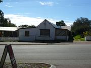
3 Weld St Gingin
Jones Shop & Residence (fmr)
Gingin
Avon Arc
Constructed from 1854
| Type | Status | Date | Documents |
|---|---|---|---|
| (no listings) |
| Type | Status | Date | Documents |
|---|---|---|---|
| (no listings) |
| Type | Status | Date | Grading/Management | |
|---|---|---|---|---|
| Category | ||||
| Municipal Inventory | Adopted | 18 Oct 2005 | Category C | |
The Shire of Gingin MI (2005) notes the house to be the oldest surviving building in Gingin
Individual Building or Group
| Epoch | General | Specific |
|---|---|---|
| Other Use | COMMERCIAL | Shop\Retail Store {single} |
| Present Use | VACANT\UNUSED | Vacant\Unused |
| Original Use | RESIDENTIAL | Single storey residence |
| Type | General | Specific |
|---|---|---|
| Wall | EARTH | Adobe {Mud Brick} |
This information is provided voluntarily as a public service. The information provided is made available in good faith and is derived from sources believed to be reliable and accurate. However, the information is provided solely on the basis that readers will be responsible for making their own assessment of the matters discussed herein and are advised to verify all relevant representations, statements and information.
Constructed from 1859
This is the oldest survivng building in Gingin.
Swan Location 262 (10 acres) was purchased by Thomas James Jones in 1859. Mr. Jones built the mud bat section as a home for his wife and himself. Believed to have been run as a small Shop by Mrs. Jones after they built a better home called the Granville. It was used as a Schoolroom c 1870. Also in the 1870's Jack Bayneham used a verandah on the south side of the building as a Blacksmith's shop. In c1900, James Ernest Prior took over the shop. It was called 'Prior Bros. Store.' Mr. Bayneham was still the Blacksmith and lived in the building. In 1924 the Shop was taken over by Mr. Bradshaw and his assistant was Cyril Riley. Cyril along with his brother Joseph eventually took over. Mrs. Jones' cottage, which was still owned by J.V.A. Jones, was sold after his death to Martin Mullins in 1933. Mr. Mullins moved the shop fittings, widened the verandah and added a kitchen and lined the interior. Mr. & Mrs. Henry Ward (M. Mullins' daughter) moved from Mooliabeenie and lived there with their family until the 1980's. R.Withnell bought the property and built a new home between the Shop and the Brook and has partly renovated the old house.
| Ref ID No | Ref Name | Ref Source | Ref Date |
|---|---|---|---|
| H Udell: "History of Gingin". |
| Owner | Category |
|---|---|
| R. Withnell | Other Private |
This information is provided voluntarily as a public service. The information provided is made available in good faith and is derived from sources believed to be reliable and accurate. However, the information is provided solely on the basis that readers will be responsible for making their own assessment of the matters discussed herein and are advised to verify all relevant representations, statements and information.
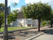
9 Weld St Gingin
Ginging Uniting Church
Methodist Church
Wesleyan Church
Gingin
Avon Arc
Constructed from 1870
| Type | Status | Date | Documents |
|---|---|---|---|
| Heritage List | Adopted | 17 Oct 2017 |
| Type | Status | Date | Documents |
|---|---|---|---|
| RHP - Does not warrant assessment | Current | 30 Apr 2004 |
| Type | Status | Date | Grading/Management | |
|---|---|---|---|---|
| Category | ||||
| Municipal Inventory | Adopted | 17 Oct 2017 | Category B | |
| Register of the National Estate | Permanent | 28 Sep 1982 | ||
| Restrictive Covenant | YES | |||
| Uniting Church Inventory | Completed | 01 Oct 1996 | ||
| Classified by the National Trust | Classified | 03 Jul 1978 | ||
Very good.
| Library Id | Title | Medium | Year Of Publication |
|---|---|---|---|
| 622 | Restoration of Gingin Uniting Church | Heritage Study {Other} | 1995 |
| 3920 | Gingin Townscape Project | Report | 1991 |
Individual Building or Group
| Epoch | General | Specific |
|---|---|---|
| Original Use | RELIGIOUS | Church, Cathedral or Chapel |
| Present Use | RELIGIOUS | Church, Cathedral or Chapel |
| Type | General | Specific |
|---|---|---|
| Roof | TIMBER | Shingle |
| Wall | BRICK | Rendered Brick |
| General | Specific |
|---|---|
| SOCIAL & CIVIC ACTIVITIES | Religion |
This information is provided voluntarily as a public service. The information provided is made available in good faith and is derived from sources believed to be reliable and accurate. However, the information is provided solely on the basis that readers will be responsible for making their own assessment of the matters discussed herein and are advised to verify all relevant representations, statements and information.
The building and its surrounds for part of the historic central precinct of gingin and enhance its character. Opened for use in 1871, this beautiful little church has served the needs of a very large area and is still in use.
This building is of clay brick with CGI roof and features. Small buttresses to the sides and corners. The side entrance door has been unsympathetically set and we urge that this be replaced with a planked door and with arching to the doorway to conform with the building's style.
Assessment 1978 Construction 1870
This information is provided voluntarily as a public service. The information provided is made available in good faith and is derived from sources believed to be reliable and accurate. However, the information is provided solely on the basis that readers will be responsible for making their own assessment of the matters discussed herein and are advised to verify all relevant representations, statements and information.
Constructed from 1870
Uniting Church is of significance for the associations with the Weslyan (Methodist) and Uniting Churches communities in the Gingin area. The Church has social and religious significance for the events that have taken place that also evoke a sense of place.
The Church is a simple rectangular form with an enclosed entry porch at the Weld Street entry (west). The roof is a steep pitch gable clad with recent shingles. The porch has a simple gable of same degree. The windows and double front doors are detailed with Gothic arches. There is a steel framed and clad addition across the rear of the church buildinq.
In 1868 Thomas James Jones gifted part of Swan Location 262 for the Wesleyan Church. Charles Masters constructed the church, getting the clay for the bricks from the gully across Weld Street. After completion in 1870, visiting clergyman Reverend Mcinnes conducted the services. In 1897, the first resident missionary, Walter Prior, was appointed. The Reverend Henry Robins was the first ordained Minister appointed in Gingin. In 1914 the manse was constructed behind the church, facing Church Street, (demolished 1969) and there was a tennis court between the house and railway line Between c.1915-1919 sisters Elsie and Ruth Rudeforth were the appointed Ministers of the congregation as lay preachers. In 1953, Missioner Creagh left the district. He was the last resident Minister.
Integrity: High degree Authenticity: Moderate/high
Good
| Ref ID No | Ref Name | Ref Source | Ref Date |
|---|---|---|---|
| H Udell: "History of Gingin". p 154 & 276 |
| Owner | Category |
|---|---|
| Uniting Church in Australia Property Trust | Church Property |
This information is provided voluntarily as a public service. The information provided is made available in good faith and is derived from sources believed to be reliable and accurate. However, the information is provided solely on the basis that readers will be responsible for making their own assessment of the matters discussed herein and are advised to verify all relevant representations, statements and information.
Loc 370 Weld St Gingin
Gingin
Avon Arc
Constructed from 1863
| Type | Status | Date | Documents |
|---|---|---|---|
| (no listings) |
| Type | Status | Date | Documents |
|---|---|---|---|
| (no listings) |
| Type | Status | Date | Grading/Management | |
|---|---|---|---|---|
| Category | ||||
| (no listings) | ||||
Individual Building or Group
| Epoch | General | Specific |
|---|---|---|
| Original Use | RESIDENTIAL | Single storey residence |
| Present Use | RESIDENTIAL | Single storey residence |
| Type | General | Specific |
|---|---|---|
| Wall | EARTH | Wattle and Daub |
| Roof | TIMBER | Shingle |
This information is provided voluntarily as a public service. The information provided is made available in good faith and is derived from sources believed to be reliable and accurate. However, the information is provided solely on the basis that readers will be responsible for making their own assessment of the matters discussed herein and are advised to verify all relevant representations, statements and information.
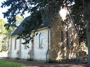
Lot 1 Weld St Gingin
Weld Street opposite the Brockman Street intersection. Lot 1 on Diagram 946.
Gingin
Avon Arc
Constructed from 1860
| Type | Status | Date | Documents |
|---|---|---|---|
| Heritage List | Adopted | 17 Oct 2017 | |
| State Register | Registered | 08 Oct 1996 | HCWebsite.Listing+ListingDocument, HCWebsite.Listing+ListingDocument |
| Type | Status | Date | Documents |
|---|---|---|---|
| (no listings) |
| Type | Status | Date | Grading/Management | |
|---|---|---|---|---|
| Category | ||||
| Municipal Inventory | Adopted | 17 Oct 2017 | Category A | |
| Classified by the National Trust | Classified | 03 Jul 1978 | ||
| Register of the National Estate | Permanent | 28 Sep 1982 | ||
| Anglican Church Inventory | YES | 31 Jul 1996 | ||
The building is in original condition.
| Name | Type | Year From | Year To |
|---|---|---|---|
| Rev George Sadler | Architect | 1862 | - |
| Library Id | Title | Medium | Year Of Publication |
|---|---|---|---|
| 4101 | Conservation Project St Lukes Anglican Church Gingin: Final Report | Heritage Study {Other} | 1999 |
| 978 | St Lukes Church Gingin: Conservation Plan | Heritage Study {Cons'n Plan} | 1995 |
| 3569 | St Luke's Anglican Church Gingin Conservation Works Stage2-Final Report | Heritage Study {Other} | 1998 |
| 3920 | Gingin Townscape Project | Report | 1991 |
Individual Building or Group
| Epoch | General | Specific |
|---|---|---|
| Present Use | RELIGIOUS | Church, Cathedral or Chapel |
| Original Use | MONUMENT\CEMETERY | Cemetery |
| Original Use | RELIGIOUS | Church Hall |
| Style |
|---|
| Vernacular |
| Victorian Free Gothic |
| Type | General | Specific |
|---|---|---|
| Roof | TIMBER | Shingle |
| Wall | STONE | Limestone |
| General | Specific |
|---|---|
| SOCIAL & CIVIC ACTIVITIES | Religion |
| DEMOGRAPHIC SETTLEMENT & MOBILITY | Settlements |
| PEOPLE | Early settlers |
This information is provided voluntarily as a public service. The information provided is made available in good faith and is derived from sources believed to be reliable and accurate. However, the information is provided solely on the basis that readers will be responsible for making their own assessment of the matters discussed herein and are advised to verify all relevant representations, statements and information.
The building and its precinct dominate the town centre and are a focus for future development activities. The most significant building in the town of Gingin. Has great historical associations for a wide area and considerable structural merit. Surrounded by the graveyard of the pioneers of the district.
St Luke’s Church of England was built in 1861. This lovely example of Gothic church architecture is built of coursed limestone. Set in it graveyard of pioneers of the district it has headmarkers of timber and stone together with its freestanding bell tower and sheltering trees. Church consecrated 22.11.1885, opened 23.2.1861. Oldest tombstone 1859 (Doncaster). Iron roof replacing shingles. Three light East window and diamond paned side windows. Embossed grisaille. The door has a massive locking key and in the porch are two arrow slit windows with white internal splays. Pew, pulpit, lectern and communion rails are local craftmanship. Font dated 1861. In 1960 service held to commemorate centenary of the Church.
Assessment 1978 Construction 1861 Opened 23.2.1861 Consecrated 22.11.1885 Oldest tombstone 1859 (Doncaster).
This information is provided voluntarily as a public service. The information provided is made available in good faith and is derived from sources believed to be reliable and accurate. However, the information is provided solely on the basis that readers will be responsible for making their own assessment of the matters discussed herein and are advised to verify all relevant representations, statements and information.
St Luke's Church, Cemetery and Belfry is significant as the first purpose-built place of worship in Gingin; and for close associations with European settlers of the Gingin district, some of whom are buried in the graveyard. The place is historically important as an example of a nineteenth century Anglican Parish Church, dating from the 1860s, set in a graveyard dating from the 1850s; and contributes to the community's sense of place as a reminder of the mid-nineteenth century development of the Ging in district and the role of religion in that development. The Church, belfry and cemetery area landmark in the setting of mature Cypress tress.
Located on the north bank of Gingin Brook, the church faces Weld Street, with an access on the north side as well, where the belfry is located. The Cemetery is located in the Weld Street frontage. A low Gothic picket fence surrounds the site. The Church is a simple rectangular form with entry porch at the west end. The steep gable roof is clad with shingles. The street frontage has a full stone gable wall with 3 stained glass windows in vertical format with gothic arched tops. A tall central window is flanked by two shorter windows. The sidewalls have steeped buttresses at regular intervals. The belfry is timber framed with a shingled hipped roof over. The path though the Cemetery from the road frontage splits in two to each side of the church.
In c.1860, the Crown allocated 12 acres of land (Pt Swan Location 265) to the Anglican Church. The stone for the church was quarried nearby. The original building did not include a vestry. A grant of 25 pounds was received on completion of the building. The Reverend George Bostock was the first chaplain, opening the church for divine service on 23 February 1861. In c.1862, Reverend George Sadler took over and built a home, remaining in Gingin until 1884. In 1862, the bell was brought from the government offices in Perth, for use by the church and the school that was utilising the church in the 1870s and 1880s. In 1899, there was concern regarding overcrowding the cemetery, and the proximity to the brook. In 1904 the Cemetery was closed except for those interred with relatives. There are many unmarked graves in the Cemetery.
Integrity : High degree Authenticity : Moderate/high degree
Good
| Ref ID No | Ref Name | Ref Source | Ref Date |
|---|---|---|---|
| H Udell: "History of Gingin". p 154 & 276 |
| Owner | Category |
|---|---|
| Perth Diocesan Trustees | Church Property |
This information is provided voluntarily as a public service. The information provided is made available in good faith and is derived from sources believed to be reliable and accurate. However, the information is provided solely on the basis that readers will be responsible for making their own assessment of the matters discussed herein and are advised to verify all relevant representations, statements and information.
Lot 2 Weld St Gingin
Lot 2 on Diagram 946. Set back a considerable distance from the church.
St Lukes Rectory
Gingin
Avon Arc
Constructed from 1898
| Type | Status | Date | Documents |
|---|---|---|---|
| Heritage List | Adopted | 17 Oct 2017 | |
| State Register | Registered | 13 Dec 1996 | HCWebsite.Listing+ListingDocument, HCWebsite.Listing+ListingDocument |
| Type | Status | Date | Documents |
|---|---|---|---|
| (no listings) |
| Type | Status | Date | Grading/Management | |
|---|---|---|---|---|
| Category | ||||
| Municipal Inventory | Adopted | 17 Oct 2017 | Category A | |
| Register of the National Estate | Permanent | 28 Sep 1982 | ||
| Anglican Church Inventory | YES | 31 Jul 1996 | ||
| Classified by the National Trust | Recorded | 03 Jul 1978 | ||
01085 St Luke's Anglican Church, Cemetery and Belfry
Timber verandah, floor largely replaced by concrete; brick addition at rear houses service areas.
Individual Building or Group
| Epoch | General | Specific |
|---|---|---|
| Present Use | RESIDENTIAL | Single storey residence |
| Original Use | RELIGIOUS | Housing or Quarters |
| Style |
|---|
| Federation Bungalow |
| Type | General | Specific |
|---|---|---|
| Roof | METAL | Corrugated Iron |
| Wall | STONE | Other Stone |
| Roof | METAL | Pressed Metal |
| Wall | TIMBER | Other Timber |
| General | Specific |
|---|---|
| SOCIAL & CIVIC ACTIVITIES | Religion |
This information is provided voluntarily as a public service. The information provided is made available in good faith and is derived from sources believed to be reliable and accurate. However, the information is provided solely on the basis that readers will be responsible for making their own assessment of the matters discussed herein and are advised to verify all relevant representations, statements and information.
Constructed from 1898
St Luke's Rectory is associated with the development of the Anglican parish in Gingin, Reverends who served the Church, and demonstrates a way of life no longer practiced.
No inspection in 2016.
The rectory is located to the northwest of the church. It was built for Ed Pritchett (for the church).
Timber verandah, floor largely replaced by concrete; brick addition at rear houses service areas.
| Ref ID No | Ref Name | Ref Source | Ref Date |
|---|---|---|---|
| H Udell: "History of Gingin". p 154 & 276 |
| Owner | Category |
|---|---|
| Perth Diocesan Trustees | Church Property |
This information is provided voluntarily as a public service. The information provided is made available in good faith and is derived from sources believed to be reliable and accurate. However, the information is provided solely on the basis that readers will be responsible for making their own assessment of the matters discussed herein and are advised to verify all relevant representations, statements and information.
Lot 3 Whakea Rd Ginginup
Gingin
Avon Arc
Constructed from 1901
| Type | Status | Date | Documents |
|---|---|---|---|
| (no listings) |
| Type | Status | Date | Documents |
|---|---|---|---|
| (no listings) |
| Type | Status | Date | Grading/Management | |
|---|---|---|---|---|
| Category | ||||
| Municipal Inventory | Adopted | 17 Nov 1994 | Category C | |
Poor
Individual Building or Group
| Epoch | General | Specific |
|---|---|---|
| Original Use | RESIDENTIAL | Single storey residence |
| Present Use | VACANT\UNUSED | Vacant\Unused |
| Type | General | Specific |
|---|---|---|
| Wall | BRICK | Other Brick |
| Roof | METAL | Corrugated Iron |
| Wall | EARTH | Adobe {Mud Brick} |
This information is provided voluntarily as a public service. The information provided is made available in good faith and is derived from sources believed to be reliable and accurate. However, the information is provided solely on the basis that readers will be responsible for making their own assessment of the matters discussed herein and are advised to verify all relevant representations, statements and information.
Constructed from 1900
The J.E. Wedge family have farmed Whakea', a part of the original Cheriton since 1895. Mrs Wedge was formerly Elizabeth Isabella Williams and they had three sons and six daughters. J.E. Wedge was a member of the Gingin Road Board for 14 years including nine years as Chairman. It is now owned by his grandson, Edward Wedge.
Approximately 350 yards form the Gingin Brook and seven kilometres from the townsite, off Cheriton Road. Mostly mud brick with a tin roof. There is a passage right down the centre and a fire place in nearly every room. The house has very high ceilings and a high pitch on the roof and verandahs almost all the way around. A brick section was added later - passage with 4 big rooms, bathroom and an extra 2 ft added to the height all around. The kitchen was enclosed off the south east corner. The house has not been lived in since 1955 when a new brick house was built nearby.
The original Cheriton Estate of W.L. Brockman was sold in 1889 and part of it was taken up by John Edgar Wedge who named the land where he lived, 'Whakea' in 1895. The eight-roomed house was built in 1901.
Poor
| Ref ID No | Ref Name | Ref Source | Ref Date |
|---|---|---|---|
| H Udell: "History of Gingin". |
This information is provided voluntarily as a public service. The information provided is made available in good faith and is derived from sources believed to be reliable and accurate. However, the information is provided solely on the basis that readers will be responsible for making their own assessment of the matters discussed herein and are advised to verify all relevant representations, statements and information.
Yanchep and Gingin
This is the 28km section of the route through the City of Wanneroo and Shire of Gingin from Yanchep to Neergabby. The entire route ran from Star Swamp to Walkaway.
Old North Rd, Coastal Stock Route, Old North
Stock Route, Champion Bay Stock Route
Gingin
Avon Arc
| Type | Status | Date | Documents |
|---|---|---|---|
| Heritage List | Adopted | 17 Oct 2017 | |
| State Register | Registered | 20 Apr 2004 | HCWebsite.Listing+ListingDocument, HCWebsite.Listing+ListingDocument |
| Type | Status | Date | Documents |
|---|---|---|---|
| (no listings) |
| Type | Status | Date | Grading/Management | |
|---|---|---|---|---|
| Category | ||||
| Aboriginal Heritage Sites Register | Interim | |||
| Aboriginal Heritage Sites Register | Permanent | |||
| Municipal Inventory | Adopted | 18 Oct 2005 | Category A | |
25092 North West Stock Route
| Library Id | Title | Medium | Year Of Publication |
|---|---|---|---|
| 7138 | The pathways of the drover. | Journal article | 1994 |
| 1047 | A time to keep: preserving the past for the present. | Book | 1994 |
Historic Site
| Epoch | General | Specific |
|---|---|---|
| Present Use | Transport\Communications | Road: Other |
| Original Use | Transport\Communications | Road: Other |
| General | Specific |
|---|---|
| DEMOGRAPHIC SETTLEMENT & MOBILITY | Land allocation & subdivision |
| TRANSPORT & COMMUNICATIONS | Droving |
| TRANSPORT & COMMUNICATIONS | Road transport |
| PEOPLE | Early settlers |
| OCCUPATIONS | Grazing, pastoralism & dairying |
This information is provided voluntarily as a public service. The information provided is made available in good faith and is derived from sources believed to be reliable and accurate. However, the information is provided solely on the basis that readers will be responsible for making their own assessment of the matters discussed herein and are advised to verify all relevant representations, statements and information.
The Stock Route is highly significant to the cultural heritage of the Shire of Gingin and the State of W.A. in that is was the major thoroughfare for travellers and drovers to the northern districts before the Midland Railway was completed. It is especially significant to the Neergabby precinct as it passed over the Old Junction Bridge and provided the majority of the patronage for the Junction Hotel, adding to the social and economic vibrancy of the area.
The North West Stock Route (fmr) comprises the site of the former road which is within the boundaries of the City of Wanneroo. The entire stock route site extends from Wanneroo through to Walkaway. The Stock Route runs from Walkaway in the Shire of Greenough to Star Swamp at North Beach in the metropolitan area. Stockyards were built and wells sunk along the route for use by drovers and their travelling livestock.
One of the earliest and one of the most important Stock Routes in Western Australia, being the one that linked the metropolitan area with the Champion Bay district. For 44 years, from 1850 unitil the Midland Railway was completed in 1894, it was the route by which many thousands of sheep and cattle were driven north to stock the new wool growing and breeding stations, and southward to provide meat for the Metropolis. Hundreds of horses travelled it either carrying people or packs, drawing carts or buggies, or just being driven loose to the fields of their new labours. In its later years, great numbers of camels were taken along it to cart water for the Murchison Goldfields and of course all these animals had people to drive them and guide them, find water and feed for them and protect them from the poison plants along the way.
| Ref ID No | Ref Name | Ref Source | Ref Date |
|---|---|---|---|
| Neergabby Community Association; "Old North Road Stock Route Concept Plan". | 2002 | ||
| M Connor; "National Trust Report". | 1989 | ||
| WJ de Burdgh; "The Old North Road". | |||
| D Gratte; "A Ride into History".. |
| Owner | Category |
|---|---|
| Shire of Gingin | Local Gov't |
| WA Wildlife Authority | State Gov't |
| Neeragabby Community Association (Inc) | Inc. Non-profit body |
| CALM | State Gov't |
| Waters and Rivers Commission | State Gov't |
| National Parks Authority | State Gov't |
This information is provided voluntarily as a public service. The information provided is made available in good faith and is derived from sources believed to be reliable and accurate. However, the information is provided solely on the basis that readers will be responsible for making their own assessment of the matters discussed herein and are advised to verify all relevant representations, statements and information.