Local Government
Busselton
Region
South West
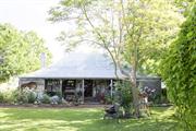
Lot 11 Albert St Busselton
Busselton
South West
Constructed from 1895
| Type | Status | Date | Documents |
|---|---|---|---|
| (no listings) |
| Type | Status | Date | Documents |
|---|---|---|---|
| (no listings) |
| Type | Status | Date | Grading/Management | |
|---|---|---|---|---|
| Category | ||||
| (no listings) | ||||
00422 The Retreat
| Name | Type | Year From | Year To |
|---|---|---|---|
| Dr Jarvis | Architect | - | - |
Individual Building or Group
| Epoch | General | Specific |
|---|---|---|
| Present Use | RESIDENTIAL | Two storey residence |
| Original Use | RESIDENTIAL | Two storey residence |
This information is provided voluntarily as a public service. The information provided is made available in good faith and is derived from sources believed to be reliable and accurate. However, the information is provided solely on the basis that readers will be responsible for making their own assessment of the matters discussed herein and are advised to verify all relevant representations, statements and information.
Blythe Rd Busselton
Forest Reserve O 139/25
Busselton
South West
| Type | Status | Date | Documents |
|---|---|---|---|
| (no listings) |
| Type | Status | Date | Documents |
|---|---|---|---|
| (no listings) |
| Type | Status | Date | Grading/Management | |
|---|---|---|---|---|
| Category | ||||
| Classified by the National Trust | Classified | 05 Apr 1993 | ||
| Municipal Inventory | Adopted | 20 Jun 1996 | Category 5 | |
The place is in good condition.
Historic site
| Epoch | General | Specific |
|---|---|---|
| Present Use | MONUMENT\CEMETERY | Grave |
| Original Use | FARMING\PASTORAL | Other |
| General | Specific |
|---|---|
| PEOPLE | Famous & infamous people |
This information is provided voluntarily as a public service. The information provided is made available in good faith and is derived from sources believed to be reliable and accurate. However, the information is provided solely on the basis that readers will be responsible for making their own assessment of the matters discussed herein and are advised to verify all relevant representations, statements and information.
There are three generations of the Isaacs family buried at this site. Connections with Sam Isaacs of “georgette” fame and also the early timber industry in the South West Well respected and successful inter-family relationships between European women and men of American-Jewish descent, combined with aboriginal lineage coming into each new generation on both sides of the families. This monument represents the successful personal contribution of multi-cultural relations both in local families and in the community at large.
Assessment 1993 Out ‘in the sticks’ in an isolated, hard to find spot, four white posts help guide the searcher through the bush to the site of three lonely graves. They are located where the second timber mill at Yallingup Siding stood. Remains of an old wooden fence lie on the ground around the comparatively recent natural stone memorial. This is about 60 Cm high with plaque attached and has been erected and cemented to the ground. Articles appearing in the ‘Margaret District Times’ in May 1957 report – While working in the vicinity of the old Quindalup Mill, three employees of Mr X.D. Power, well known Busselton timber miller, found three old graves. They were only mounds but at one time there had been wooden railings, the remains of which were visible. In one of these forgotten graves lies buried Mrs Lucy Isaacs, who was the wife of Sam Isaacs, who is still remembered by many for his part in the saving of so many lives from the ship “Georgette”. Sam Isaacs was born in Augusta in c. 1845. His father, Sam of part American negro and Jewish descent jumped ship in Albany from an American whaling boat. He met an aboriginal woman and Sam Isaacs Jr was their only child. Mrs Isaacs died in November 1893 (the plaque reads 1883). Another grave situated alongside was that of her baby who died just before the mother. The third grave was that of Mrs Mattie Purvis, who died some four years later. Mrs Purvis had been married twice, being originally married to Major Lowe, who before his death was on a whaling ship. Mattie Purvis (the mother of Lucy Lowe) was English and her first husband Major James Lowe was an American soldier who had obtained his rank in the American Civil War. Lucy Lowe married Sam Isaacs at Wallcliffe, Margaret Ricer on 8 January 1870 and they had six children. In December 1876 the wreck of the coastal steamer Georgette at Caldargup (Redgate) brought world attention to the area. Sam Isaacs, then aged about 56 years, and Grace Bussell, braved rough turbulent seas to rescue survivors from the ship which had foundered off the coast. Both Sam Isaacs and Grace Bussell were awarded medals by the Royal Humane Society in recognition of their bravery and selfless courage. For many years the black and white painting of the rescue scene of passengers from the Georgette, now in the August Museum, hung in pride of place over the lounge room mantle piece in the home of Frederick Augusta Isaacs (1882 – 1956) in Margaret River.
This information is provided voluntarily as a public service. The information provided is made available in good faith and is derived from sources believed to be reliable and accurate. However, the information is provided solely on the basis that readers will be responsible for making their own assessment of the matters discussed herein and are advised to verify all relevant representations, statements and information.
Lucy Isaac’s grave site, a private burial place has cultural heritage significance as the burial place of three generations of the Isaacs’ family. One of the most notable members of the family is Sam Isaac, well known for his efforts of saving the passengers of the ‘Georgette’ shipwreck. As one of the earliest Aboriginal settlers, his bravery placed a good light onto indigenous people as a social group who in the 1900s, like Sam, were still regarded as the ‘black servants’ to prominent families such as the Bussell family.
Three graves in a bush setting.
The site was originally used as a pasture but became the burying ground for three generations of the Isaacs’ family. Sam Yeseble Isaac was a renowned Aboriginal settler who worked as a stockman for the Bussell family on their Margaret River property. Lucy Isaacs’ husband, Sam was notable in the history of Busselton, in particular the timber industry. He was most well remembered for risking his life to save the passengers of the ailing ship, the ‘Georgette’ in 1876. The steam sailing ship departed from Fremantle, carrying a load of jarrah timber bound for the Eastern States only to meet with flooding problems at the ship’s hull as it approached the shores of Busselton. The heroic and quick actions of Sam together with 16–year old Grace Bussell saved many grief-stricken passengers of the shipwreck. The ‘Georgette’s rare mission to transport human cargo comprising a small group of Fenians, members of the Irish Republican Brotherhood from Fremantle to Adelaide drew worldwide attention to this incident.
High Degree/ High Degree
Good
| Ref ID No | Ref Name | Ref Source | Ref Date |
|---|---|---|---|
| http://www.wilja.asn.au/georgette.htm | |||
| http://www.abc.net.au/backyard/shipwrecks/wa/georgette.htm |
| Owner | Category |
|---|---|
| Dept of Conservation & Land Management | State Gov't |
This information is provided voluntarily as a public service. The information provided is made available in good faith and is derived from sources believed to be reliable and accurate. However, the information is provided solely on the basis that readers will be responsible for making their own assessment of the matters discussed herein and are advised to verify all relevant representations, statements and information.
12 Bussell Hwy Busselton
Busselton Mitsubishi
Busselton
South West
Constructed from 1880
| Type | Status | Date | Documents |
|---|---|---|---|
| (no listings) |
| Type | Status | Date | Documents |
|---|---|---|---|
| (no listings) |
| Type | Status | Date | Grading/Management | |
|---|---|---|---|---|
| Category | ||||
| Classified by the National Trust | Recorded | 02 Feb 1976 | ||
| Municipal Inventory | Adopted | 13 Sep 2006 | Category 5 | |
Individual Building or Group
| Epoch | General | Specific |
|---|---|---|
| Original Use | RESIDENTIAL | Single storey residence |
| Present Use | COMMERCIAL | Other |
| Style |
|---|
| Victorian Filigree |
| Type | General | Specific |
|---|---|---|
| Wall | STONE | Limestone |
| Roof | METAL | Corrugated Iron |
| Other | BRICK | Other Brick |
| General | Specific |
|---|---|
| PEOPLE | Early settlers |
This information is provided voluntarily as a public service. The information provided is made available in good faith and is derived from sources believed to be reliable and accurate. However, the information is provided solely on the basis that readers will be responsible for making their own assessment of the matters discussed herein and are advised to verify all relevant representations, statements and information.
Constructed from 1880
Site of ‘Yarrie-Mia’ has cultural heritage significance as the site of a once fine house and as the residence of James Savage a prominent Busselton builder who was active in the district in the second half of the 19th century.
Symmetrical in design it featured twin gables with corrugated iron on the roof. contained several magnificent leaded panels featuring Australian animals. The place was demolished to enable the building of Fennessy’s car yard in the early 1990s.
Previous home of James Savage, who was a prominent builder in the south west during the second half of the 19th Century. Built c1880s of cut limestone blocks with brick quoins and chamfered verandah posts. Born Norwich England in 1847. James arrived in Fremantle in the late 1860s after serving as a ship’s carpenter for a number of years. The property is reputed to have been given to James, who was living in Nannup, after he swam across the Blackwood and walked about 65 kilometres to Busselton to find a doctor for the Nannup Policeman’s wife, who was seriously ill. James married Hannah Grace Fordham, born Fremantle 1857. The newly married Savages took up a property about six kilometres west of town, naming the property Seaview. Several of the Savages 13 children were born at Seaview before it was burnt down. James Savage was a carpenter and wheelwright of outstanding ability and took on contracts to build houses, bridges, jetties, horse drawn carts and wagons. He worked for M.C. Davis of Karridale Timber mill and John Garrett Bussell at Cattle Chosen. He is reported to have won a contract for the Busselton Jetty extensions.
Site Only
| Ref ID No | Ref Name | Ref Source | Ref Date |
|---|---|---|---|
| Busselton-Margaret River Times; "Monument to a craftsman of early Busselton", | 10 May 1979 |
| Owner | Category |
|---|---|
| BA & AH Stacey | Other Private |
This information is provided voluntarily as a public service. The information provided is made available in good faith and is derived from sources believed to be reliable and accurate. However, the information is provided solely on the basis that readers will be responsible for making their own assessment of the matters discussed herein and are advised to verify all relevant representations, statements and information.
41 Bussell Hwy Busselton
Busselton
South West
Constructed from 1890
| Type | Status | Date | Documents |
|---|---|---|---|
| Heritage List | YES | 13 Aug 2014 |
| Type | Status | Date | Documents |
|---|---|---|---|
| (no listings) |
| Type | Status | Date | Grading/Management | |
|---|---|---|---|---|
| Category | ||||
| Municipal Inventory | Adopted | 13 Sep 2006 | Category 2 | |
The place is in good condition.
Individual Building or Group
| Epoch | General | Specific |
|---|---|---|
| Present Use | COMMERCIAL | Other |
| Original Use | RESIDENTIAL | Single storey residence |
| Type | General | Specific |
|---|---|---|
| Roof | METAL | Corrugated Iron |
| Wall | STONE | Limestone |
| General | Specific |
|---|---|
| PEOPLE | Early settlers |
This information is provided voluntarily as a public service. The information provided is made available in good faith and is derived from sources believed to be reliable and accurate. However, the information is provided solely on the basis that readers will be responsible for making their own assessment of the matters discussed herein and are advised to verify all relevant representations, statements and information.
Constructed from 1890
Busselton Vet, a stone, stucco and iron roofed former residence in the Federation Georgian style, has cultural heritage significance as a picturesque building that retains strong aesthetic value.
Busselton Vet is built of random limestone blocks, with ashlar marked lime mortar to the façade. The sides comprise random stone. The house has a hipped roof with chamfered verandah posts. The front windows have a fixed top light with a double casement below – from a distance they appear similar to sash windows. There are stucco quoins and a full width front verandah carried on stop-chamfered posts. A large addition from the 1990s to the rear relates to the place’s use as a veterinary clinic. A large peppermint tree obscures views of part of the front of the place.
The house was built at the same time as and by the same builder, John Muir, as Paisley Cottage (37 Bussell Highway). It was home to the Finlayson family for many years.
Moderate Degree/Good Degree Integrity Notes: The place remains legible as a house and retains a moderate degree of integrity. Authenticity Notes: The place has been altered in a number of ways including a large addition, but retains a good deal of authentic fabric.
Good
| Owner | Category |
|---|---|
| D.R. Richards | Other Private |
This information is provided voluntarily as a public service. The information provided is made available in good faith and is derived from sources believed to be reliable and accurate. However, the information is provided solely on the basis that readers will be responsible for making their own assessment of the matters discussed herein and are advised to verify all relevant representations, statements and information.
500 Bussell Hwy Busselton
Busselton
South West
Constructed from 1960
| Type | Status | Date | Documents |
|---|---|---|---|
| Heritage List | YES | 13 Aug 2014 |
| Type | Status | Date | Documents |
|---|---|---|---|
| (no listings) |
| Type | Status | Date | Grading/Management | |
|---|---|---|---|---|
| Category | ||||
| Municipal Inventory | Adopted | 13 Aug 2014 | Category 3 | |
| Municipal Inventory | Adopted | 13 Sep 2006 | Category 3 | |
The place is in excellent condition, having been maintained by the same owners from its construction to the present day.
| Name | Type | Year From | Year To |
|---|---|---|---|
| RM Neale | Architect | 1960 | - |
Individual Building or Group
| Epoch | General | Specific |
|---|---|---|
| Original Use | SOCIAL\RECREATIONAL | Theatre or Cinema |
| Present Use | SOCIAL\RECREATIONAL | Theatre or Cinema |
| General | Specific |
|---|---|
| SOCIAL & CIVIC ACTIVITIES | Sport, recreation & entertainment |
This information is provided voluntarily as a public service. The information provided is made available in good faith and is derived from sources believed to be reliable and accurate. However, the information is provided solely on the basis that readers will be responsible for making their own assessment of the matters discussed herein and are advised to verify all relevant representations, statements and information.
Constructed from 1960
Busselton Drive-In Theatre has cultural heritage significance as a rare surviving example that grew quickly throughout Western Australia in the immediate Post World War II period and has since has almost disappeared as a class of place.
Drive‐In Theatre. Set in a beautifully landscaped garden, the Drive-in Cinema is enclosed within stonewall and steel fence.
Nil
The place retains a high degree of integrity. The place retains a high degree of authenticity. The majority of the fabric is in its original state, with the exception of the screen, which was originally of timber frame construction on steel supports set into concrete blocks. The timber was replaced in July 2002 with steel as a result of storm damage in the same month.
The place is in excellent condition, having been maintained by the same owners from its construction to the present day.
| Name | Type | Year From | Year To |
|---|---|---|---|
| R.M. Neale | Architect | - | - |
| Ron & Valmae Jones | Architect | - | - |
| Ref ID No | Ref Name | Ref Source | Ref Date |
|---|---|---|---|
| Informant: Ron Jones Busselton | 09/1997 | ||
| Allan Jones | Reminiscences of a Travelling Picture Showman, Busselton | 1974 | |
| Allan Jones | 1978 | ||
| Interview (Ina Bertrand & Irma Whitford) | |||
| Heritage Council of Western Australia | Register of Heritage Places (Draft Only) | ||
| Film Weekly Directory | 1961/2-1971 | ||
| Public Health Department, building permit, Battye 14592 | |||
| Film Weekly p.7 | 5/01/1961 | ||
| Max Bell | Perth, a cinema history | ||
| Lews, Sussex pp.132 | The Book Guild Ltd | 1986 |
| Ref Number | Description |
|---|---|
| 524855 | Landgate Pin |
| 172 | Reference No. |
| Reserve | Lot/Location | Plan/Diagram | Vol/Folio |
|---|---|---|---|
| 3 |
This information is provided voluntarily as a public service. The information provided is made available in good faith and is derived from sources believed to be reliable and accurate. However, the information is provided solely on the basis that readers will be responsible for making their own assessment of the matters discussed herein and are advised to verify all relevant representations, statements and information.
between Bussell Hwy & Rendezvous Rd Busselton
Broadwater Reserve
Busselton
South West
| Type | Status | Date | Documents |
|---|---|---|---|
| (no listings) |
| Type | Status | Date | Documents |
|---|---|---|---|
| (no listings) |
| Type | Status | Date | Grading/Management | |
|---|---|---|---|---|
| Category | ||||
| (no listings) | ||||
Urban Open Space
| Epoch | General | Specific |
|---|---|---|
| Present Use | PARK\RESERVE | Park\Reserve |
| Original Use | PARK\RESERVE | Park\Reserve |
| Type | General | Specific |
|---|---|---|
| Roof | METAL | Corrugated Iron |
| General | Specific |
|---|---|
| OTHER | Other Sub-Theme |
This information is provided voluntarily as a public service. The information provided is made available in good faith and is derived from sources believed to be reliable and accurate. However, the information is provided solely on the basis that readers will be responsible for making their own assessment of the matters discussed herein and are advised to verify all relevant representations, statements and information.
Recognised as important freshwater wetlands providing essential habitat, feeding and nesting areas for many species, particularly migratory water birds. Protected pursuant to the Environmental Protection Act as a Swan Coastal Plain wetland. A landmark natural feature. The wildlife attracted to the wetlands creates interest to the community and tourists alike.
| Owner | Category |
|---|---|
| State of WA (Vested in the National Parks and Nature Conservation Authority) | State Gov't |
This information is provided voluntarily as a public service. The information provided is made available in good faith and is derived from sources believed to be reliable and accurate. However, the information is provided solely on the basis that readers will be responsible for making their own assessment of the matters discussed herein and are advised to verify all relevant representations, statements and information.
Bussell Hwy/Vasse Hwy Busselton
Near junction with the Vasse Highway, Busselton Shire.
Part of Cattle Chosen subdivision
Busselton
South West
Constructed from 1834 to 1836
| Type | Status | Date | Documents |
|---|---|---|---|
| (no listings) |
| Type | Status | Date | Documents |
|---|---|---|---|
| (no listings) |
| Type | Status | Date | Grading/Management | |
|---|---|---|---|---|
| Category | ||||
| Classified by the National Trust | Recorded | 04 Oct 1971 | ||
| Municipal Inventory | Adopted | 20 Jun 1996 | Category 5 | |
| Municipal Inventory | Adopted | 13 Aug 2014 | Category 5 | |
| Name | Type | Year From | Year To |
|---|---|---|---|
| Vernon Bussell | Architect | 1834 | 1836 |
| Library Id | Title | Medium | Year Of Publication |
|---|---|---|---|
| 7189 | Very much on watch : the Percy Willmott photos : Augusta, Margaret River, Busselton 1901 - 1919. | Book | 2003 |
Individual Building or Group
| Epoch | General | Specific |
|---|---|---|
| Present Use | FARMING\PASTORAL | Other |
| Original Use | FARMING\PASTORAL | Homestead |
| General | Specific |
|---|---|
| OCCUPATIONS | Grazing, pastoralism & dairying |
This information is provided voluntarily as a public service. The information provided is made available in good faith and is derived from sources believed to be reliable and accurate. However, the information is provided solely on the basis that readers will be responsible for making their own assessment of the matters discussed herein and are advised to verify all relevant representations, statements and information.
Reinscourt, a historic site, has cultural heritage significance as part of the original Cattle Chosen subdivision and its associations with the Bussell family, one of the pioneer families in the district. It remains to be one of the earliest homesteads in the district and is closely related to ‘Cattle Chosen’, another Bussell homestead built in 1834-1836.
Site of Reinscourt Homestead. Not inspected
‘Reinscourt’ Homestead was initially part of the original subdivision of ‘Cattle Chosen’ and built by Vernon Bussell. Construction of ‘Cattle Chosen’ was carried out in 1834-36. Following its completion in 1836, all of the Bussell family migrated from England to Augusta. This marked a mass migration of other settlers to the Vasse River area.
Not Applicable Not Applicable
Not inspected
| Ref Number | Description |
|---|---|
| 534433 | Landgate Pin |
| 116 | Reference No. |
| Reserve | Lot/Location | Plan/Diagram | Vol/Folio |
|---|---|---|---|
| 41 |
This information is provided voluntarily as a public service. The information provided is made available in good faith and is derived from sources believed to be reliable and accurate. However, the information is provided solely on the basis that readers will be responsible for making their own assessment of the matters discussed herein and are advised to verify all relevant representations, statements and information.
Busselton to Boyanup Busselton
Busselton
South West
Constructed from 1895
| Type | Status | Date | Documents |
|---|---|---|---|
| (no listings) |
| Type | Status | Date | Documents |
|---|---|---|---|
| RHP - Does not warrant assessment | Current | 11 Oct 2019 |
| Type | Status | Date | Grading/Management | |
|---|---|---|---|---|
| Category | ||||
| Municipal Inventory | Adopted | 20 Jun 1996 | Category 5 | |
Historic Site
| Epoch | General | Specific |
|---|---|---|
| Present Use | Transport\Communications | Rail: Other |
| Original Use | Transport\Communications | Rail: Other |
| General | Specific |
|---|---|
| TRANSPORT & COMMUNICATIONS | Rail & light rail transport |
This information is provided voluntarily as a public service. The information provided is made available in good faith and is derived from sources believed to be reliable and accurate. However, the information is provided solely on the basis that readers will be responsible for making their own assessment of the matters discussed herein and are advised to verify all relevant representations, statements and information.
Constructed from 1895
Busselton-Boyanup Rail Line has cultural heritage significance for its historic value in the development of the local timber and dairy industry.
Historic railway route, remains of the railway line can still be seen.
| Owner | Category |
|---|---|
| Westrail | State Gov't |
This information is provided voluntarily as a public service. The information provided is made available in good faith and is derived from sources believed to be reliable and accurate. However, the information is provided solely on the basis that readers will be responsible for making their own assessment of the matters discussed herein and are advised to verify all relevant representations, statements and information.
Adjac Cammilleri St Busselton
Busselton
South West
Constructed from 1890
| Type | Status | Date | Documents |
|---|---|---|---|
| (no listings) |
| Type | Status | Date | Documents |
|---|---|---|---|
| RHP - Does not warrant assessment | Current | 11 Oct 2019 |
| Type | Status | Date | Grading/Management | |
|---|---|---|---|---|
| Category | ||||
| (no listings) | ||||
Individual Building or Group
| Epoch | General | Specific |
|---|---|---|
| Original Use | Transport\Communications | Rail: Other |
| Present Use | VACANT\UNUSED | Vacant\Unused |
| Type | General | Specific |
|---|---|---|
| Roof | METAL | Corrugated Iron |
| Wall | TIMBER | Other Timber |
| General | Specific |
|---|---|
| TRANSPORT & COMMUNICATIONS | Rail & light rail transport |
This information is provided voluntarily as a public service. The information provided is made available in good faith and is derived from sources believed to be reliable and accurate. However, the information is provided solely on the basis that readers will be responsible for making their own assessment of the matters discussed herein and are advised to verify all relevant representations, statements and information.
Constructed from 1890
The Busselton Railway Precinct has cultural heritage significance for its historic value and its role as part of a transport system linking the region to its port.
The railway precinct includes the site of the former railway station; railway goods shed site, residence - (single men’s quarters), the railway line, locomotive shed, and station masters house. Some sections of track, a crossing over the Vasse River and a railway workers cottage remain on the site. The railway station has been relocated to reserve 2236 (lot 41). The railway line exists over part of the reserve. There are few remaining features apart from some track, a works cottage and the relocated timber construction station building.
The area included marshalling yards, a bridge over the Vasse River, station, goods shed, quarters, locomotive shed, station master’s house and permanent way. The station was removed and relocated to its present site and almost all of the buildings and infrastructure removed.
There is likely to be archaeological evidence of railway activity in a number of locations along the route. The less disturbed the site the higher thearchaeological potential.
| Ref Number | Description |
|---|---|
| PN027 | MI Reference |
| Owner | Category |
|---|---|
| Westrail | State Gov't |
This information is provided voluntarily as a public service. The information provided is made available in good faith and is derived from sources believed to be reliable and accurate. However, the information is provided solely on the basis that readers will be responsible for making their own assessment of the matters discussed herein and are advised to verify all relevant representations, statements and information.
Lot 37 Causeway Rd Busselton
Opposite Rosemary Drive.
BB02
Busselton
South West
Constructed from 1892
| Type | Status | Date | Documents |
|---|---|---|---|
| (no listings) |
| Type | Status | Date | Documents |
|---|---|---|---|
| RHP - Does not warrant assessment | Current | 29 Jul 2011 |
| Type | Status | Date | Grading/Management | |
|---|---|---|---|---|
| Category | ||||
| (no listings) | ||||
Bridge is in poor condition, the decking has failed and is an extreme risk to the public due to its high visibility. PTA recommends the removal or permanent barricading of the bridge. Warning signs are also recommended.
Historic site
| Epoch | General | Specific |
|---|---|---|
| Original Use | Transport\Communications | Rail: Other |
| Present Use | Transport\Communications | Rail: Other |
| Type | General | Specific |
|---|---|---|
| Other | TIMBER | Log |
| General | Specific |
|---|---|
| TRANSPORT & COMMUNICATIONS | Rail & light rail transport |
This information is provided voluntarily as a public service. The information provided is made available in good faith and is derived from sources believed to be reliable and accurate. However, the information is provided solely on the basis that readers will be responsible for making their own assessment of the matters discussed herein and are advised to verify all relevant representations, statements and information.
1087 Caves Rd Busselton
Government building
Harwoods Beach Station (fmr)
Harwood's Cottage Cafe
Inlet Villa
Old Quindalup Post Office (fmr)
Slab Cottage, Harwood's Cafe & Quindalup Post Office
Busselton
South West
Constructed from 1860
| Type | Status | Date | Documents |
|---|---|---|---|
| Heritage List | YES | 13 Aug 2014 | |
| State Register | Registered | 20 Sep 2002 | HCWebsite.Listing+ListingDocument, HCWebsite.Listing+ListingDocument |
| Type | Status | Date | Documents |
|---|---|---|---|
| (no listings) |
| Type | Status | Date | Grading/Management | |
|---|---|---|---|---|
| Category | ||||
| Municipal Inventory | Adopted | 13 Sep 2006 | Category 1 | |
The place is in good condition, undergoing restoration and conversion into a cafe in 2000.
| Library Id | Title | Medium | Year Of Publication |
|---|---|---|---|
| 5018 | Harwood's Cottage, Quindalup : conservation works. Final report. January 2001 | Report | 2001 |
| 5562 | Harwood's Cottage Quindalup conservation works: final report. | Conservation works report | 2002 |
| 7003 | Slab cottage, Quindalup : conservation and adaptive works (final report). | Conservation works report | 2004 |
| 4574 | Inlet Villa : 1002 Caves Road, Quindalup, W.A. : conservation plan | Heritage Study {Cons'n Plan} | 2000 |
Individual Building or Group
| Epoch | General | Specific |
|---|---|---|
| Present Use | Transport\Communications | Comms: Post or Telegraph Office |
| Present Use | RESIDENTIAL | Single storey residence |
| Present Use | COMMERCIAL | Restaurant |
| Original Use | RESIDENTIAL | Single storey residence |
| Original Use | GOVERNMENTAL | Gaol |
| Original Use | INDUSTRIAL\MANUFACTURING | Dairy, Butter or Cheese Factory |
| Style |
|---|
| Vernacular |
| Type | General | Specific |
|---|---|---|
| Wall | TIMBER | Slab |
| Wall | STONE | Limestone |
| Roof | METAL | Corrugated Iron |
| Wall | TIMBER | Weatherboard |
| General | Specific |
|---|---|
| DEMOGRAPHIC SETTLEMENT & MOBILITY | Settlements |
| OCCUPATIONS | Grazing, pastoralism & dairying |
| SOCIAL & CIVIC ACTIVITIES | Law & order |
| OCCUPATIONS | Rural industry & market gardening |
| TRANSPORT & COMMUNICATIONS | Telecommunications |
| TRANSPORT & COMMUNICATIONS | River & sea transport |
| TRANSPORT & COMMUNICATIONS | Mail services |
| TRANSPORT & COMMUNICATIONS | Technology & technological change |
| OCCUPATIONS | Timber industry |
| PEOPLE | Early settlers |
This information is provided voluntarily as a public service. The information provided is made available in good faith and is derived from sources believed to be reliable and accurate. However, the information is provided solely on the basis that readers will be responsible for making their own assessment of the matters discussed herein and are advised to verify all relevant representations, statements and information.
Constructed from 1860
Slab Cottage has cultural heritage significance, as it remains one of the few 19th century residences that are clad with split timber slabs and characterises vernacular cottages design during the colonial period. At a macro level, the group of buildings exemplify a well-designed integrative design. The place is significant for its close association with the Quindalup timber mill and jetty. The oldest buildings serve as a reminder of the once bustling district that had a substantial population. Historical significance is also derived for the place’s links to the operations of customs and the police during Quindalup’s early life. In today’s context, the cottage contributes to a community’s sense of place. Furthermore, the buildings are linked to the Harwood family, early settlers of the region. John Harwood (B. 1840) and wife were among the first settlers and he was said to teach at the neighbouring school. William Harwood (b. 1870) was a member of Quindalup Social Club in the 1930s. At a micro level, the internal planning of the cottage demonstrates a now defunct way of life. The Quindalup Post Office was significant in its role of providing postal and telephone services in the area between 1923 and 1966. The barn and government building represent colonial masonry work and construction detailing.
Slab Cottage comprises a split timber slab and weatherboard cottage, a freestanding weatherboard kitchen, a three room limestone and iron building (known as the government building) and a three sided rubble limestone barn. The Slab Cottage has a plain, unadorned and symmetrical façade topped by a spreading hipped roof. It is designed in Colonial style with a prominent front verandah. The patina of age that has accumulated on the exterior of the barn and Government Building contributes to a rich layering of colours and texture that not only speaks of the buildings’ age but merges well with the surroundings.
The buildings were close associated with the growth of the timber industry and the Quindalup jetty. Early evidence shows that the outbuildings were used as a bond store and a lock-up. During the period from 1923 to 1966, the Quindalup Post Office and telephone exchange centre were established on the site. The Harwood family, pioneers in the district occupied the Slab Cottage for approximately 100 years. They played a pro-active role in the local community development including managing the district’s post office and telephone exchange.
The place contains potential archaeological findings that may shed light on the early domestic ways of the rural working class, in particular European settlers of the 19th century. Some of the artefacts include 19th and early 20th century ceramics and glassware in close proximity to the cottage.
High Degre/Moderate Degree Integrity Notes: The Slab Cottage retains a high degree of integrity despite some changes to the western perimeter rooms. The kitchen building is in poor condition. The government building and barn are also in poor condition. The roof is also in poor condition due to neglect. Authenticity Notes: The place retains a moderate degree of authenticity, as although most of the original fabric remains intact with the finishes in deteriorated state, there have been considerable alterations to the building. The internal linings of the western rooms, weatherboards on the eastern side and corrugated iron roof were replaced. The ground level at the front of the cottage has been lowered, window sashes reconstructed and new electrical connections installed.
The place is in good condition, undergoing restoration and conversion into a café in 2000.
| Ref ID No | Ref Name | Ref Source | Ref Date |
|---|---|---|---|
| "Inlet Villa: 1002 Caves Road, Quindalup, WA: Conservation Plan". | 2000 | ||
| "Harwood's Cottage Quindalup conservation works: final report". | 2002 | ||
| "Slab Cottage, Quindalup: conservation and adaptive works (final report)". | 2004 |
| Owner | Category |
|---|---|
| Norma Blanche Andrews | Other Private |
This information is provided voluntarily as a public service. The information provided is made available in good faith and is derived from sources believed to be reliable and accurate. However, the information is provided solely on the basis that readers will be responsible for making their own assessment of the matters discussed herein and are advised to verify all relevant representations, statements and information.
Chapman Hill Rd Busselton
Busselton
South West
Constructed from 2003
| Type | Status | Date | Documents |
|---|---|---|---|
| (no listings) |
| Type | Status | Date | Documents |
|---|---|---|---|
| (no listings) |
| Type | Status | Date | Grading/Management | |
|---|---|---|---|---|
| Category | ||||
| Municipal Inventory | Adopted | 13 Sep 2006 | Category 4 | |
The plaque is in good condition.
Historic Site
| Epoch | General | Specific |
|---|---|---|
| Present Use | MONUMENT\CEMETERY | Monument |
| Original Use | MONUMENT\CEMETERY | Monument |
| Type | General | Specific |
|---|---|---|
| Other | STONE | Other Stone |
| Other | METAL | Bronze |
| General | Specific |
|---|---|
| DEMOGRAPHIC SETTLEMENT & MOBILITY | Settlements |
This information is provided voluntarily as a public service. The information provided is made available in good faith and is derived from sources believed to be reliable and accurate. However, the information is provided solely on the basis that readers will be responsible for making their own assessment of the matters discussed herein and are advised to verify all relevant representations, statements and information.
Constructed from 2003
Group 40 Memorial has cultural heritage significance as it commemorates all those whose were part of the Group 30 Group Settlement Scheme.
Sponsored by the Bunbury Port Authority, the plaque was erected to commemorate the bravery of early settlers to the region in the 1930s. It is made from concrete and has all the names on a cast bronze plaque
Historical Notes: WA was the only state to push ahead with a vigorous scheme of land settlement tied to immigration, both being government sponsored. Immigrants were given the chance to settle either on eastern wheat farms or on dairy farms in the undeveloped districts of the south-western region. Group settlers arrived in the area between 1920-30. A district office for Agricultural Bank opened at Busselton on 8 May1923. The loans Department of Agriculture was a special fund administered by the Lands Department to provide loans recorded as average £50 per dwelling. The money was advanced for clearing and fencing of land. Theoretically, a group settler was deemed to be self-supporting when he was able to maintain a herd of 10 cows – the estimated limit for 25 acres of pasture. The Honourable Sir James Mitchell was the principal architect of the Group Settlement Scheme, to develop the south-western portion of the State by establishing dairy farms in that area, which was inaugurated in WA in 1921. On 2 February 1923, by virtue of an agreement between the British, the Commonwealth and the WA Governments, the State undertook to settle in the South-West division about 75,000 migrants (men, women and children) from the United Kingdom over 3 years and to establish about 6000 selected men from among these migrants on about 600 farms in the division. The Scheme provided that these selected migrants were to be placed in groups of 20 or more under supervision. Each group was to clear or partially clear 25 acres on each farm. The group was also to erect the house and necessary outbuildings on each farm, put up fencing and arrange for a satisfactory water supply. Advances for sustenance at a rate not exceeding 10/- per day were to be made to settlers whilst engaged in clearing and the State was to provide the material for all buildings, fencing, etc. besides providing reasonable equipment and stock. The farms, when cleared to the extent of 25 acres, were to be allotted to members of the group by ballot. Of the first 16 groups organised, 9 were in the Busselton district, giving impetus primarily to the dairy industry. The Group Settlements afforded primitive and isolated living conditions, and the results were varying degrees of measured success and a high proportion of failure. All settlers were affected by the world-wide downturn in agricultural produce prices during the 1930’s and many Group Settlement blocks were left idle, pastured but neglected.
High Degree/High Degree Integrity Notes: The place retains a high degree of integrity. Authenticity Notes: The place retains a high degree of authenticity.
Good
This information is provided voluntarily as a public service. The information provided is made available in good faith and is derived from sources believed to be reliable and accurate. However, the information is provided solely on the basis that readers will be responsible for making their own assessment of the matters discussed herein and are advised to verify all relevant representations, statements and information.
Crossing Vasse River, via Fairlawn Rd Busselton
Earnshaw's Crossing
Busselton
South West
| Type | Status | Date | Documents |
|---|---|---|---|
| (no listings) |
| Type | Status | Date | Documents |
|---|---|---|---|
| (no listings) |
| Type | Status | Date | Grading/Management | |
|---|---|---|---|---|
| Category | ||||
| Municipal Inventory | Adopted | 20 Jun 1996 | Category 5 | |
Landscape
| Epoch | General | Specific |
|---|---|---|
| Present Use | Transport\Communications | Road: Other |
| Original Use | Transport\Communications | Road: Other |
| General | Specific |
|---|---|
| TRANSPORT & COMMUNICATIONS | Road transport |
This information is provided voluntarily as a public service. The information provided is made available in good faith and is derived from sources believed to be reliable and accurate. However, the information is provided solely on the basis that readers will be responsible for making their own assessment of the matters discussed herein and are advised to verify all relevant representations, statements and information.
Fairlawn Lane Crossing, a low water level river crossing point is significant as an early river crossing point for early Busselton district settlers, prior to the construction of bridges.
Natural river crossing point, the river bed is of rock at this point. No built features.
An early river crossing point for early settlers before the construction of a bridge crossing when water levels were low. The corner of Fairlawn Road and Strelly Street is the site of the original gaol c1830s close to and on the other side of the river to Fairlawn, the home of Colonel Molloy, the first Busselton Magistrate. This is believed to have been the area of the centre of the government authority before The Gulch (Customs officer’s house and police station) was built (now rear of 22 Kent St Busselton) and the building of the gaol and courthouse in c1850.
| Owner | Category |
|---|---|
| Shire of Busselton | Local Gov't |
This information is provided voluntarily as a public service. The information provided is made available in good faith and is derived from sources believed to be reliable and accurate. However, the information is provided solely on the basis that readers will be responsible for making their own assessment of the matters discussed herein and are advised to verify all relevant representations, statements and information.
31 Duchess St Busselton
Busselton
South West
Constructed from 1900
| Type | Status | Date | Documents |
|---|---|---|---|
| Heritage List | YES | 13 Aug 2014 |
| Type | Status | Date | Documents |
|---|---|---|---|
| (no listings) |
| Type | Status | Date | Grading/Management | |
|---|---|---|---|---|
| Category | ||||
| Municipal Inventory | Adopted | 13 Aug 2014 | Category 2 | |
| Municipal Inventory | Adopted | 13 Sep 2006 | Category 2 | |
The place is in good condition.
Individual Building or Group
| Epoch | General | Specific |
|---|---|---|
| Present Use | VACANT\UNUSED | Vacant\Unused |
| Original Use | RESIDENTIAL | Single storey residence |
| Style |
|---|
| Federation Bungalow |
| Type | General | Specific |
|---|---|---|
| Other | ASBESTOS | Fibrous Cement, flat |
| Wall | BRICK | Other Brick |
| Roof | METAL | Corrugated Iron |
| Wall | STONE | Limestone |
| General | Specific |
|---|---|
| DEMOGRAPHIC SETTLEMENT & MOBILITY | Settlements |
| OCCUPATIONS | Domestic activities |
This information is provided voluntarily as a public service. The information provided is made available in good faith and is derived from sources believed to be reliable and accurate. However, the information is provided solely on the basis that readers will be responsible for making their own assessment of the matters discussed herein and are advised to verify all relevant representations, statements and information.
Constructed from 1900
House 31 Duchess Street, a brick, limestone and iron residence in the Federation Bungalow style residence has cultural heritage significance as a fine and relatively intact example of the style.
Single storey brick and limestone and iron house. The house was built c1900. No. 31, Duchess Street is Federation Bungalow style residence constructed with random and coursed limestone with brick quoins to the front door and windows. It is topped by a hipped roof, punctured by a galvanised iron flue and chimney. French bay windows flank the main entrance and project onto the verandah, thereby emphasizing the entry statement. The verandah posts appear to have been replaced with brick pillars. A fibro cement clad addition to the side of the building diminishes the building’s authenticity. The lawn appears to be unkempt presumably due to neglect and the house displays a considerable problem with damp. The block on lot 64 originally ran through from Duchess St to Adelaide St. The rates book from 1896 shows all of the blocks in Duchess St on this side of the road ran through to Adelaide St with a lane way servicing night carts ran dividing the middle of the blocks. This lane was, in part resumed by the Shire of Busselton in 2000, however the lane in the area behind these buildings is extant.
Nil
The place retains a high degree of integrity. The place retains a high degree of authenticity.
Good
| Ref Number | Description |
|---|---|
| 533366 | Landgate Pin |
| 167 | Reference No. |
| Reserve | Lot/Location | Plan/Diagram | Vol/Folio |
|---|---|---|---|
| 413 |
| Owner | Category |
|---|---|
| Ian McKenzie | Other Private |
This information is provided voluntarily as a public service. The information provided is made available in good faith and is derived from sources believed to be reliable and accurate. However, the information is provided solely on the basis that readers will be responsible for making their own assessment of the matters discussed herein and are advised to verify all relevant representations, statements and information.
33 & 35 Duchess St Busselton
Busselton
South West
Constructed from 1909
| Type | Status | Date | Documents |
|---|---|---|---|
| Heritage List | YES | 13 Aug 2014 |
| Type | Status | Date | Documents |
|---|---|---|---|
| (no listings) |
| Type | Status | Date | Grading/Management | |
|---|---|---|---|---|
| Category | ||||
| Municipal Inventory | Adopted | 13 Sep 2006 | Category 2 | |
| Municipal Inventory | Adopted | 13 Aug 2014 | Category 2 | |
The place is in good condition.
| Name | Type | Year From | Year To |
|---|---|---|---|
| Eustace Cohen | Architect | 1909 | - |
Individual Building or Group
| Epoch | General | Specific |
|---|---|---|
| Present Use | RESIDENTIAL | Single storey residence |
| Original Use | RESIDENTIAL | Single storey residence |
| Style |
|---|
| Federation Bungalow |
| Type | General | Specific |
|---|---|---|
| Wall | BRICK | Common Brick |
| Roof | TILE | Cement Tile |
| General | Specific |
|---|---|
| OCCUPATIONS | Domestic activities |
| DEMOGRAPHIC SETTLEMENT & MOBILITY | Settlements |
This information is provided voluntarily as a public service. The information provided is made available in good faith and is derived from sources believed to be reliable and accurate. However, the information is provided solely on the basis that readers will be responsible for making their own assessment of the matters discussed herein and are advised to verify all relevant representations, statements and information.
Constructed from 1909
33 & 35 Duchess Street, a brick and tiled Federation Bungalow styled duplex, has cultural heritage significance as a good and unusual example of the style applied to a duplex residence in the context of Busselton.
Brick, stucco and tiled roof Federation Bungalow style duplex.
An unusual place in the Busselton area, this is a Federation Bungalow style duplex, with brick construction walls and stucco trim and a steeply pitched gambrel pattern concrete tiled roof. It has a full width front verandah, supported on stop-chamfered posts with decorative post brackets. The place has a timber picket fence and a simple neat garden. The building was owned by J. Thomas, who built four units in the form of two duplex buildings on the site. Nos 1 & 2 Duchess St. and 3 & 4 in Adelaide St. The block originally ran through from Duchess St to Adelaide Street in 1896 (rates book), as was the case with all of the blocks in this street at this time. Four units were built on Lot 65 and a lane way servicing night carts ran through the middle of the blocks dividing the Adelaide and Duchess Street Frontages. This lane was, in part resumed by the Shire of Busselton in 2000, however the lane in the area behind these buildings is extant. The building is situated directly over the road from the Busselton Hospital site. No, 6 was built to house the Matron of the Hospital, while No. 8 housed the Hospital Doctor.
The place retains a high degree of integrity. The place retains a high degree of authenticity.
Good
| Ref Number | Description |
|---|---|
| 166 | Reference No. |
| 533373 & 533370 | Landgate Pin |
| Reserve | Lot/Location | Plan/Diagram | Vol/Folio |
|---|---|---|---|
| 1&2 |
This information is provided voluntarily as a public service. The information provided is made available in good faith and is derived from sources believed to be reliable and accurate. However, the information is provided solely on the basis that readers will be responsible for making their own assessment of the matters discussed herein and are advised to verify all relevant representations, statements and information.
38 Duchess St Busselton
Busselton
South West
Constructed from 1906, Constructed from 2003
| Type | Status | Date | Documents |
|---|---|---|---|
| Heritage List | YES | 13 Aug 2014 |
| Type | Status | Date | Documents |
|---|---|---|---|
| (no listings) |
| Type | Status | Date | Grading/Management | |
|---|---|---|---|---|
| Category | ||||
| Municipal Inventory | Adopted | 20 Jun 1996 | Category 3 | |
| Statewide Hotel Survey | Completed | 01 Nov 1997 | ||
The place has been refurbished and is in good condition.
Individual Building or Group
| Epoch | General | Specific |
|---|---|---|
| Present Use | COMMERCIAL | Hotel, Tavern or Inn |
| Original Use | COMMERCIAL | Hotel, Tavern or Inn |
| Style |
|---|
| Federation Filigree |
| Type | General | Specific |
|---|---|---|
| Wall | PLASTER | Other Plaster |
| Roof | METAL | Corrugated Iron |
| Wall | BRICK | Painted Brick |
| General | Specific |
|---|---|
| SOCIAL & CIVIC ACTIVITIES | Sport, recreation & entertainment |
This information is provided voluntarily as a public service. The information provided is made available in good faith and is derived from sources believed to be reliable and accurate. However, the information is provided solely on the basis that readers will be responsible for making their own assessment of the matters discussed herein and are advised to verify all relevant representations, statements and information.
Constructed from 2003, Constructed from 1906
The Vasse Hotel, a two storey brick, stucco and iron roofed Federation Filigree style building with substantial additions, has cultural heritage significance as a local landmark, as a substantial fragment of a fine buildings and for its contribution to the Queen Street streetscape. It is also significant as a meeting place and a place for social occasions since 1906.
A two-storey Federation Free Classical style building, now part of a shopping complex. Description Notes: The Vasse Hotel now comprises the 1906 building on the corner of Queen and Duchess streets, with a shopping centre to the south and west. The original section of the building had a two-storey timber construction filigree style verandah, brick walls, stucco decorative treatments, an iron roof, tall double hung sash windows and timber-framed doors. It is a distinctive element in the streetscape and like most country hotels takes full advantage of its corner to make an architectural statement. The verandahs are very deep, but the present fabric is all replacement material. The parapet detail remains authentic, with its cornice, panels and acroteria and the words Vasse Hotel in bas-relief. Almost all openings have been altered and several of the original openings have been bricked in.
The Vasse Hotel was built by Robert Donald and Son and like many hotels underwent numerous changes to accommodate changing needs. The changes were generally confined to the ground floor until the building was completely renovated and changed significantly during the 2002-3 shopping centre project. The place is now part of Busselton Central Shopping Centre. The place now contains a café and tavern and a large part of the other improvements associated with the hotel were demolished to make way for the new work.
Low Degree/Low Degree Integrity Notes: The place retains some of the hotel style function but has changed so much that its integrity is low. Authenticity Notes: The remaining building contains both authentic and replacement material. Overall its authenticity is low.
Good
| Owner | Category |
|---|---|
| Queen Street Properties Pty Ltd. | Other Private |
This information is provided voluntarily as a public service. The information provided is made available in good faith and is derived from sources believed to be reliable and accurate. However, the information is provided solely on the basis that readers will be responsible for making their own assessment of the matters discussed herein and are advised to verify all relevant representations, statements and information.
43 Duchess St Busselton
Busselton
South West
| Type | Status | Date | Documents |
|---|---|---|---|
| Heritage List | YES | 13 Aug 2014 |
| Type | Status | Date | Documents |
|---|---|---|---|
| (no listings) |
| Type | Status | Date | Grading/Management | |
|---|---|---|---|---|
| Category | ||||
| Municipal Inventory | Adopted | 13 Sep 2006 | Category 2 | |
The place is in good condition.
Individual Building or Group
| Epoch | General | Specific |
|---|---|---|
| Original Use | RESIDENTIAL | Single storey residence |
| Present Use | RESIDENTIAL | Single storey residence |
| Style |
|---|
| Federation Bungalow |
| Type | General | Specific |
|---|---|---|
| Wall | BRICK | Common Brick |
| Other | TILE | Other Tile |
| Roof | METAL | Corrugated Iron |
| General | Specific |
|---|---|
| DEMOGRAPHIC SETTLEMENT & MOBILITY | Settlements |
| OCCUPATIONS | Domestic activities |
This information is provided voluntarily as a public service. The information provided is made available in good faith and is derived from sources believed to be reliable and accurate. However, the information is provided solely on the basis that readers will be responsible for making their own assessment of the matters discussed herein and are advised to verify all relevant representations, statements and information.
House 43 Duchess Street has cultural heritage significance as a good example of a brick and iron Federation Bungalow style house.
A single storey brick and iron residence.
The lot originally ran through from Duchess St to Adelaide Street in 1896 (rates book), common to all the blocks in the street. A lane way servicing night carts ran through the middle of the blocks dividing the Adelaide and Duchess Street Frontages. This lane was, in part resumed by the Shire of Busselton in 2000, however the lane in the area behind these buildings is extant.
High Degree/High Degree Integrity Notes: The place retains a high degree of integrity. Authenticity Notes: The place retains a high degree of authenticity.
Good
| Owner | Category |
|---|---|
| WJ Taylor | Other Private |
This information is provided voluntarily as a public service. The information provided is made available in good faith and is derived from sources believed to be reliable and accurate. However, the information is provided solely on the basis that readers will be responsible for making their own assessment of the matters discussed herein and are advised to verify all relevant representations, statements and information.
70 Duchess St Busselton
St Vincent de Pauls (site of)
Busselton
South West
Constructed from 1930
| Type | Status | Date | Documents |
|---|---|---|---|
| (no listings) |
| Type | Status | Date | Documents |
|---|---|---|---|
| (no listings) |
| Type | Status | Date | Grading/Management | |
|---|---|---|---|---|
| Category | ||||
| Municipal Inventory | Adopted | 20 Jun 1996 | Category 3 | |
The place is in good condition. With the exception of the small section to the right of the buildings, which is an addition, the balance of the facade is original. The chamfered verandah posts have been shortened and now rest on brick pillars. Major additions to the back of the house took place in the early 1990s. The original house was small with a garage on the left side, no longer extant.
| Library Id | Title | Medium | Year Of Publication |
|---|---|---|---|
| 8548 | The life and work of Marion St Clair layman: a craftswoman of her time. | Heritage Study {Other} | 2001 |
Individual Building or Group
| Epoch | General | Specific |
|---|---|---|
| Original Use | RESIDENTIAL | Single storey residence |
| Present Use | SOCIAL\RECREATIONAL | Other |
| Present Use | COMMERCIAL | Office or Administration Bldg |
| Style |
|---|
| Inter-War California Bungalow |
| Type | General | Specific |
|---|---|---|
| Roof | METAL | Zincalume |
| Wall | BRICK | Rendered Brick |
| General | Specific |
|---|---|
| SOCIAL & CIVIC ACTIVITIES | Religion |
This information is provided voluntarily as a public service. The information provided is made available in good faith and is derived from sources believed to be reliable and accurate. However, the information is provided solely on the basis that readers will be responsible for making their own assessment of the matters discussed herein and are advised to verify all relevant representations, statements and information.
Constructed from 1930
St Vincent de Pauls, a brick and iron dwelling in the Inter-War California Bungalow style building, now used as offices, has cultural heritage significance as an example of the style and as the local headquarters of the local St Vincent de Pauls charitable organisation. The dwelling is significant on the following grounds:
A simple rendered brick and iron house in the Inter-War California Bungalow style. It has a gable roof with the ends half-timbered. The original verandah posts have been replaced. Miss Layman is believed to be the original occupant. A simple single storey rendered brick and custom orb roof dwelling in the Inter-War California Bungalow style, it presents simple part timbered gables to the street and would appear to have been rendered in more recent times. The place is in good condition. With the exception of the small section to the right of the building, which is an addition, the balance of the facade is original. The chamfered verandah posts have been shortened and now rest on brick pillars. Major additions to the back of the house took place in the early 1990s. The original house was small with a garage on the left side, No longer extant.
Marian St. Clair Layman (of Wonnerup House) was the first owner of the house. She is well respected for her wood carving skills and left a legacy of ornate carvings within the house. A gate carved by Layman is located at Wonnerup House. Miss Layman carved a well known overmantel at Wonnerup House. The place is now run as a St. Vincent de Paul shop, in conjunction with the local Catholic Church.
Integrity Notes: The place is no longer a dwelling, but its original use remains reasonably apparent. The place retains a moderate degree of integrity. Authenticity Notes: The place has been altered and original detail lost. It retains a moderate degree of authenticity. Moderate Degree/Moderate Degree
Good
| Owner | Category |
|---|---|
| Society of St Vincent de Paul WA Inc | Inc. Non-profit body |
This information is provided voluntarily as a public service. The information provided is made available in good faith and is derived from sources believed to be reliable and accurate. However, the information is provided solely on the basis that readers will be responsible for making their own assessment of the matters discussed herein and are advised to verify all relevant representations, statements and information.
170 Duke St Busselton
Busselton
South West
Constructed from 1970
| Type | Status | Date | Documents |
|---|---|---|---|
| (no listings) |
| Type | Status | Date | Documents |
|---|---|---|---|
| (no listings) |
| Type | Status | Date | Grading/Management | |
|---|---|---|---|---|
| Category | ||||
| Uniting Church Inventory | Completed | 01 Oct 1996 | ||
| Classified by the National Trust | Classified | 04 Apr 1977 | ||
Individual Building or Group
| Epoch | General | Specific |
|---|---|---|
| Present Use | RELIGIOUS | Housing or Quarters |
| Original Use | RELIGIOUS | Housing or Quarters |
| Type | General | Specific |
|---|---|---|
| Roof | TILE | Ceramic Tile |
| Wall | BRICK | Common Brick |
| General | Specific |
|---|---|
| SOCIAL & CIVIC ACTIVITIES | Religion |
This information is provided voluntarily as a public service. The information provided is made available in good faith and is derived from sources believed to be reliable and accurate. However, the information is provided solely on the basis that readers will be responsible for making their own assessment of the matters discussed herein and are advised to verify all relevant representations, statements and information.
Constructed from 1903
The building has architectural merit.
The walls of the place are dressed granite blocks at the front, and rubble granite at the sides, with corners outlined in render, and bricked on one side. The main roof is aluminium, and the verandah roof is corrugated iron. Special features of the building include plentiful ornamenting of plaster and wood, elaborately turned posts supporting the verandah and its wooden ornamentation and the portico entrance made of granite. The fence of the building has four rounded tops on posts, and the chimney shapes are unusual. The portico entrance has tessilated tile flooring, while the rest of the verandah floor is wood.
The building remains well kept.
This information is provided voluntarily as a public service. The information provided is made available in good faith and is derived from sources believed to be reliable and accurate. However, the information is provided solely on the basis that readers will be responsible for making their own assessment of the matters discussed herein and are advised to verify all relevant representations, statements and information.
Ford Rd intersection with Vasse River Busselton
Banks of the Vasse River
Estuary Crossing (fmr)
Busselton
South West
Constructed from 1839
| Type | Status | Date | Documents |
|---|---|---|---|
| (no listings) |
| Type | Status | Date | Documents |
|---|---|---|---|
| (no listings) |
| Type | Status | Date | Grading/Management | |
|---|---|---|---|---|
| Category | ||||
| Municipal Inventory | Adopted | 20 Jun 1996 | Category 5 | |
| Classified by the National Trust | Recorded | 04 Oct 1971 | ||
Apparently fair.
Historic Site
| Epoch | General | Specific |
|---|---|---|
| Present Use | Transport\Communications | Road: Other |
| Original Use | Transport\Communications | Road: Other |
| General | Specific |
|---|---|
| TRANSPORT & COMMUNICATIONS | Road transport |
This information is provided voluntarily as a public service. The information provided is made available in good faith and is derived from sources believed to be reliable and accurate. However, the information is provided solely on the basis that readers will be responsible for making their own assessment of the matters discussed herein and are advised to verify all relevant representations, statements and information.
Constructed from 1839
The Ford Road Causeway has cultural heritage significance for it historic value as an important travel route from the hinterland to the coast and in particular provided a crossing from the Bussell’s ‘Cattle Chosen’.
A natural river ford with access to it via unmade gravel roads.
The site was where the early settlers forded the Vasse River to gain access to Busselton and the coast.
Moderate Degree
Fair
| Owner | Category |
|---|---|
| Shire of Busselton | Local Gov't |
This information is provided voluntarily as a public service. The information provided is made available in good faith and is derived from sources believed to be reliable and accurate. However, the information is provided solely on the basis that readers will be responsible for making their own assessment of the matters discussed herein and are advised to verify all relevant representations, statements and information.