Local Government
Busselton
Region
South West
74 Queen St Busselton
Mitchell Park
Busselton
South West
Constructed from 1867
| Type | Status | Date | Documents |
|---|---|---|---|
| (no listings) |
| Type | Status | Date | Documents |
|---|---|---|---|
| (no listings) |
| Type | Status | Date | Grading/Management | |
|---|---|---|---|---|
| Category | ||||
| Municipal Inventory | Adopted | 20 Jun 1996 | Category 4 | |
05324 Mitchell Park Precinct
Historic Site
| Epoch | General | Specific |
|---|---|---|
| Present Use | SOCIAL\RECREATIONAL | Other |
| Original Use | SOCIAL\RECREATIONAL | Other |
| General | Specific |
|---|---|
| SOCIAL & CIVIC ACTIVITIES | Institutions |
This information is provided voluntarily as a public service. The information provided is made available in good faith and is derived from sources believed to be reliable and accurate. However, the information is provided solely on the basis that readers will be responsible for making their own assessment of the matters discussed herein and are advised to verify all relevant representations, statements and information.
Constructed from 1872
The site of the Working Man’s Institute has cultural heritage significance as the site of one of the earliest institutes to be build in Busselton.
No built features remain
Historical Notes: The original stone Working Men’s Institute that occupied the site was established with Government assistance in 1872. Some time after 1909 the building was vested with the Shire for the establishment of a library. The building was demolished and replaced by a new library in 1963.
Site Only
| Owner | Category |
|---|---|
| Shire of Busselton | Local Gov't |
This information is provided voluntarily as a public service. The information provided is made available in good faith and is derived from sources believed to be reliable and accurate. However, the information is provided solely on the basis that readers will be responsible for making their own assessment of the matters discussed herein and are advised to verify all relevant representations, statements and information.
89 Queen St Busselton
Cnr Prince St
Busselton
South West
Constructed from 1911
| Type | Status | Date | Documents |
|---|---|---|---|
| Heritage List | YES | 13 Aug 2014 |
| Type | Status | Date | Documents |
|---|---|---|---|
| (no listings) |
| Type | Status | Date | Grading/Management | |
|---|---|---|---|---|
| Category | ||||
| Municipal Inventory | Adopted | 13 Aug 2014 | Category 2 | |
| Municipal Inventory | Adopted | 20 Jun 1996 | Category 2 | |
The building appears to be in good condition.
Individual Building or Group
| Epoch | General | Specific |
|---|---|---|
| Present Use | COMMERCIAL | Shop\Retail Store {single} |
| Original Use | COMMERCIAL | Shop\Retail Store {single} |
| Style |
|---|
| Federation Free Classical |
| Type | General | Specific |
|---|---|---|
| Roof | METAL | Corrugated Iron |
| Wall | BRICK | Common Brick |
| General | Specific |
|---|---|
| OCCUPATIONS | Commercial & service industries |
This information is provided voluntarily as a public service. The information provided is made available in good faith and is derived from sources believed to be reliable and accurate. However, the information is provided solely on the basis that readers will be responsible for making their own assessment of the matters discussed herein and are advised to verify all relevant representations, statements and information.
Constructed from 1911
Sussex House, a two storey stucco and iron shopping and residential building in the Federation Free Classical style, has cultural heritage significance as a good example of its style and is a local landmark. Sussex is an important part of the Queen Street townscape.
A two storey stuccoed brick and iron shopping and residential building in a version of the Federation Free Classical style. Located on the corner of Queen and Prince streets, Sussex House is a two storey Federation Free Classical style commercial building with a strong landmark value. It comprises shops on the ground floor and had residences on the first floor. The building originally had a two storey verandah, so that the detail below the first floor verandah roof level is simply treated. The verandah has been replace by a cantilevered awning. The architectural flourishes are reserved for the street side parapet, where a deep balustrade and pediments provide a richly decorative building top and skyline.
On the previous site of ‘Sussex House’ and during the 1890s a house was constructed and lived in by the Hough family. The Hough family sold drapery from their home before constructing a small timber ‘general and drapery’ store on this corner. The place served as a boarding house during World War II. The store was later owned by Mr Prosser, who included a couple of banks into the building.
The building continues to serve its original function and retains a high degree of integrity. Sussex House originally had a corner axis with timber balcony with ‘oriental’ style balustrade. The building displayed early signage ‘M.R. Whitton Stationery’. Though it has lost its verandah but otherwise retains much of its original fabric. It retains a moderate degree of authenticity. High Degree/Moderate Degree
Good
| Ref Number | Description |
|---|---|
| 533819 | Landgate Pin |
| 55 | Reference No. |
| Reserve | Lot/Location | Plan/Diagram | Vol/Folio |
|---|---|---|---|
| 10 |
This information is provided voluntarily as a public service. The information provided is made available in good faith and is derived from sources believed to be reliable and accurate. However, the information is provided solely on the basis that readers will be responsible for making their own assessment of the matters discussed herein and are advised to verify all relevant representations, statements and information.
Lot 119 Queen St Busselton
Busselton
South West
Constructed from 1910
| Type | Status | Date | Documents |
|---|---|---|---|
| (no listings) |
| Type | Status | Date | Documents |
|---|---|---|---|
| (no listings) |
| Type | Status | Date | Grading/Management | |
|---|---|---|---|---|
| Category | ||||
| Fire & Rescue Service Heritage Inventory | Adopted | 30 Aug 1997 | ||
Historic Site
| Epoch | General | Specific |
|---|---|---|
| Original Use | GOVERNMENTAL | Fire Station |
| Present Use | VACANT\UNUSED | Vacant\Unused |
| General | Specific |
|---|---|
| SOCIAL & CIVIC ACTIVITIES | Community services & utilities |
This information is provided voluntarily as a public service. The information provided is made available in good faith and is derived from sources believed to be reliable and accurate. However, the information is provided solely on the basis that readers will be responsible for making their own assessment of the matters discussed herein and are advised to verify all relevant representations, statements and information.
Queen St, cnr Albert St Busselton
Church, Graveyard, Rectory & Hall site
Busselton
South West
Constructed from 1914
| Type | Status | Date | Documents |
|---|---|---|---|
| (no listings) |
| Type | Status | Date | Documents |
|---|---|---|---|
| (no listings) |
| Type | Status | Date | Grading/Management | |
|---|---|---|---|---|
| Category | ||||
| Classified by the National Trust | Classified | 12 Jun 1968 | ||
| Municipal Inventory | Adopted | 20 Jun 1996 | Category 5 | |
| Library Id | Title | Medium | Year Of Publication |
|---|---|---|---|
| 10138 | S.A. Mounted Constable John Brabazon Forsayth (c.1882 - 1852). Gentleman architect shot dead in an affray with a snake. | Electronic | 0 |
Individual Building or Group
| Epoch | General | Specific |
|---|---|---|
| Other Use | RELIGIOUS | Church Hall |
| Original Use | RELIGIOUS | Housing or Quarters |
| Original Use | RELIGIOUS | Church, Cathedral or Chapel |
| Original Use | RELIGIOUS | Church Hall |
| Style |
|---|
| Federation Carpenter Gothic |
| General | Specific |
|---|---|
| SOCIAL & CIVIC ACTIVITIES | Religion |
This information is provided voluntarily as a public service. The information provided is made available in good faith and is derived from sources believed to be reliable and accurate. However, the information is provided solely on the basis that readers will be responsible for making their own assessment of the matters discussed herein and are advised to verify all relevant representations, statements and information.
Constructed from 1914
St Mary’s Anglican Church Hall site has cultural heritage significance for its association with the church and its related functions over an extended period of time, a function that the parish family centre continues to the present.
A timber and iron church hall in the Federation Carpenter GothicStyle. The hall was relocated to Lot 26 Layman Road Wonnerup.
The hall was built in 1914. The original timber hall was re-located to Lockville at Wonnerup on Lot 26 Layman Road in the 1990s. A new family parish centre was erected on the church hall site.
Given the length of use of the site, there may be some archaeological potential.
The site continues to serve a similar purpose to that which it did when occupied by the church hall so that it retains a degree of integrity.
Site Only
| Owner | Category |
|---|---|
| St Mary's Parish- Anglican Diocese | Church Property |
This information is provided voluntarily as a public service. The information provided is made available in good faith and is derived from sources believed to be reliable and accurate. However, the information is provided solely on the basis that readers will be responsible for making their own assessment of the matters discussed herein and are advised to verify all relevant representations, statements and information.
Signal Park, Marine Tce Busselton
Busselton
South West
Constructed from 1979, Constructed from 1853
| Type | Status | Date | Documents |
|---|---|---|---|
| (no listings) |
| Type | Status | Date | Documents |
|---|---|---|---|
| (no listings) |
| Type | Status | Date | Grading/Management | |
|---|---|---|---|---|
| Category | ||||
| Municipal Inventory | Adopted | 20 Jun 1996 | Category 4 | |
The sundial is in good condition.
Historic site
| Epoch | General | Specific |
|---|---|---|
| Original Use | MONUMENT\CEMETERY | Monument |
| Present Use | MONUMENT\CEMETERY | Monument |
| Type | General | Specific |
|---|---|---|
| Wall | BRICK | Other Brick |
| General | Specific |
|---|---|
| SOCIAL & CIVIC ACTIVITIES | Sport, recreation & entertainment |
This information is provided voluntarily as a public service. The information provided is made available in good faith and is derived from sources believed to be reliable and accurate. However, the information is provided solely on the basis that readers will be responsible for making their own assessment of the matters discussed herein and are advised to verify all relevant representations, statements and information.
Constructed from 1979, Constructed from 1853
The Sundial, a brick and bronze construction memorial has cultural heritage significance as part of a tradition of commemorating historic moments in Western Australian history and is a landmark in Busselton that is an indication of community pride.
A brick and bronze construction sundial. The sundial is set at the corner of Signal Park near the Queen Street and Marine Terrace junction. It is set amongst brick edged garden beds and a small bronze sundial is located on top of a brick plinth.
After the initial erection of the sundial in 1853 it was re-erected in 1929 to mark the first Centenary of WA by Sussex Lodge of Freemasons. It was re-erected in September 1979 to commemorate the Western Australian Sesqui - Centenary by the Sussex Lodge.
Moderate Degree/Low Degree Integrity Notes: The sundial, the third on the site, functions as intended and has a moderate degree of integrity. Authenticity Notes: The sundial on the site continues a long established tradition of sundials in this location and has a low degree of authenticity.
Good
| Owner | Category |
|---|---|
| Shire of Busselton | Local Gov't |
This information is provided voluntarily as a public service. The information provided is made available in good faith and is derived from sources believed to be reliable and accurate. However, the information is provided solely on the basis that readers will be responsible for making their own assessment of the matters discussed herein and are advised to verify all relevant representations, statements and information.
Cnr Stanley & Camilleri Sts Busselton
Busselton
South West
Constructed from 1989
| Type | Status | Date | Documents |
|---|---|---|---|
| (no listings) |
| Type | Status | Date | Documents |
|---|---|---|---|
| (no listings) |
| Type | Status | Date | Grading/Management | |
|---|---|---|---|---|
| Category | ||||
| Fire & Rescue Service Heritage Inventory | Adopted | 30 Aug 1997 | ||
Individual Building or Group
| Epoch | General | Specific |
|---|---|---|
| Original Use | GOVERNMENTAL | Fire Station |
| Present Use | GOVERNMENTAL | Fire Station |
| Type | General | Specific |
|---|---|---|
| Wall | BRICK | Common Brick |
| Roof | TILE | Other Tile |
| General | Specific |
|---|---|
| SOCIAL & CIVIC ACTIVITIES | Community services & utilities |
This information is provided voluntarily as a public service. The information provided is made available in good faith and is derived from sources believed to be reliable and accurate. However, the information is provided solely on the basis that readers will be responsible for making their own assessment of the matters discussed herein and are advised to verify all relevant representations, statements and information.
Cnr Stanley & Kent Sts Busselton
Old Railway Cottage Site
Busselton
South West
Constructed from 1900
| Type | Status | Date | Documents |
|---|---|---|---|
| (no listings) |
| Type | Status | Date | Documents |
|---|---|---|---|
| (no listings) |
| Type | Status | Date | Grading/Management | |
|---|---|---|---|---|
| Category | ||||
| Municipal Inventory | Adopted | 20 Jun 1996 | Category 4 | |
05325 Old WA Government Railway Precinct
Individual Building or Group
| Epoch | General | Specific |
|---|---|---|
| Original Use | Transport\Communications | Rail: Housing or Quarters |
| Present Use | VACANT\UNUSED | Vacant\Unused |
| Style |
|---|
| Vernacular |
| Type | General | Specific |
|---|---|---|
| Wall | PLASTER | Fibrous Plaster Sheet |
| Wall | TIMBER | Other Timber |
| Roof | METAL | Corrugated Iron |
| General | Specific |
|---|---|
| TRANSPORT & COMMUNICATIONS | Rail & light rail transport |
This information is provided voluntarily as a public service. The information provided is made available in good faith and is derived from sources believed to be reliable and accurate. However, the information is provided solely on the basis that readers will be responsible for making their own assessment of the matters discussed herein and are advised to verify all relevant representations, statements and information.
Constructed from 1900
Railway works cottage was amongst the last of the dwellings associated with the railway to remain and is significant as a site that was part of the network.
A modest remnant workers cottage in a local vernacular building style. The original outbuildings and fence remain intact. Nothing remains
The place was one of number of building constructed along the line as part of the railway network. Four long buildings housed railway employees on this site. The buildings consisted of weatherboard with corrugated iron roof and ran parallel to Stanley Street. They were situated between the railway lines – one line to either side of the dwellings. The workers used the area between the buildings as access to the dwellings. The area is now Shire carpark. Close to the railway employees’ buildings (but outside the lines) and to the north-east was the Railway Master’s house (extant).
Site Only
| Owner | Category |
|---|---|
| Shire of Busselton | Local Gov't |
This information is provided voluntarily as a public service. The information provided is made available in good faith and is derived from sources believed to be reliable and accurate. However, the information is provided solely on the basis that readers will be responsible for making their own assessment of the matters discussed herein and are advised to verify all relevant representations, statements and information.
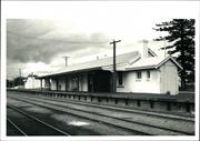
Stanley St Busselton
Busselton
South West
| Type | Status | Date | Documents |
|---|---|---|---|
| (no listings) |
| Type | Status | Date | Documents |
|---|---|---|---|
| (no listings) |
| Type | Status | Date | Grading/Management | |
|---|---|---|---|---|
| Category | ||||
| (no listings) | ||||
05325 Old WA Government Railway Precinct
Individual Building or Group
| Epoch | General | Specific |
|---|---|---|
| Original Use | Transport\Communications | Rail: Railway Station |
| Present Use | Transport\Communications | Rail: Railway Station |
This information is provided voluntarily as a public service. The information provided is made available in good faith and is derived from sources believed to be reliable and accurate. However, the information is provided solely on the basis that readers will be responsible for making their own assessment of the matters discussed herein and are advised to verify all relevant representations, statements and information.
This information is provided voluntarily as a public service. The information provided is made available in good faith and is derived from sources believed to be reliable and accurate. However, the information is provided solely on the basis that readers will be responsible for making their own assessment of the matters discussed herein and are advised to verify all relevant representations, statements and information.
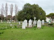
Stanley St, cnr Adelaide St & Marine Tce Busselton
Burial Ground
Marine Terrace Cemetery
Pioneer Cemetery
Busselton
South West
Constructed from 1847 to 1932
| Type | Status | Date | Documents |
|---|---|---|---|
| State Register | Registered | 15 May 1998 | HCWebsite.Listing+ListingDocument, HCWebsite.Listing+ListingDocument |
| Type | Status | Date | Documents |
|---|---|---|---|
| (no listings) |
| Type | Status | Date | Grading/Management | |
|---|---|---|---|---|
| Category | ||||
| Municipal Inventory | Adopted | 20 Jun 1996 | Category 1 | |
| Classified by the National Trust | Classified {HBS} | |||
| Register of the National Estate | Indicative Place | |||
| Register of the National Estate | Nominated | 01 Jan 1989 | ||
The place is in fair condition, notwithstanding the damage caused by vandalism and gradual deterioration of the markers.
| Library Id | Title | Medium | Year Of Publication |
|---|---|---|---|
| 9342 | Old Busselton Cemetery Marine Terrace, Stanley and Adelaide Streets , Busselton. DRAFT | Heritage Study {Cons'n Plan} | 2009 |
| 9448 | Old Busselton Cemetery. Marine Terrace, Stanley and Adelaide Streets, Busselton. | Heritage Study {Cons'n Plan} | 2009 |
| 6606 | Register of historic burial sites as at June 1988. | Report | 1988 |
Other Built Type
| Epoch | General | Specific |
|---|---|---|
| Present Use | MONUMENT\CEMETERY | Cemetery |
| Original Use | MONUMENT\CEMETERY | Cemetery |
| Type | General | Specific |
|---|---|---|
| Wall | STONE | Limestone |
| General | Specific |
|---|---|
| PEOPLE | Early settlers |
This information is provided voluntarily as a public service. The information provided is made available in good faith and is derived from sources believed to be reliable and accurate. However, the information is provided solely on the basis that readers will be responsible for making their own assessment of the matters discussed herein and are advised to verify all relevant representations, statements and information.
NATURAL ENVIRONMENT This place is considered significant because of social and historical importance. Social importance is that of all cemeteries for their respective communities. Historical importance is because of the very early establishment of the cemetery when the townsite was first surveyed, as shown on the townsite plan of 1839 and 1844. It is one of the oldest cemeteries in the state. A number of early pioneers of of the district have extant monuments herein. CULTURAL ENVIRONMENT This cemetery contains two excellent examples of timber slab monuments. There are also some monuments that were made in other colonies, possible illustrating either cheaper manufacture in other colonies or cheaper transport from there than from Perth. Lanscape value is significant because the site was used as it occurred naturally, with the sandhills still remaining, as shown on the site plan and photographs. Graves were located on sandhills as well as in the valleys and level areas. It's landscape value in the past has been nil because it was alongside a working railway. If the cemetery is developed as a pioneer park, now that the railway is not used it will make a pleasant contribution to the townscape. Scarcity value as for all cemeteries is of paramount value as each person has only one place of burial.
Closed cemetery, containing approximately 50 monuments
Assessment 1985 Set aside when townsite surveyed c. 1834. last interments c.1930
This information is provided voluntarily as a public service. The information provided is made available in good faith and is derived from sources believed to be reliable and accurate. However, the information is provided solely on the basis that readers will be responsible for making their own assessment of the matters discussed herein and are advised to verify all relevant representations, statements and information.
Constructed from 1847, Constructed from 1932
Old Busselton Cemetery, an undulating coastal area of just over one hectare contains over 250 graves, has cultural heritage significance as the burial place for many people involved in the European settlement of the region and of members of families prominent in the early history of Western Australia. The place is one of the earliest non-indigenous cemeteries in Western Australia and the oldest in the region. The place is aesthetically significant as a cultural landscape, a topographically unusual cemetery and an important collection of monumental head markers and it is highly valued by the community for its religious, historical, familial and social associations.
The cemetery contains the graves of many of the early settlers from the district. Many peppermint trees have been established within the grounds. The boundary along Stanley St. is marked with limestone pillars. The cemetery contains two excellent examples of timber slab monuments. There are also some monuments that were made in other colonies, possibly illustrating either cheaper manufacture in other colonies or cheaper transport from there than from Perth. Landscape value is significant because the site was used as it occurred naturally, with the sand hills still remaining, as shown on the site plan and photographs. Graves were located on sand hills as well as in the valleys and level areas. Its landscape value in the past has been nil because it was alongside a working railway.
The place has 250 recorded burials and was planned as early as 1839 though the first burial did not take place until 1847, while it was not formally proclaimed a cemetery until 1856 when a notice appeared in WA Government Gazette. Though the first recorded burial was in 1864, the first burial has been established that Henry John Yelverton was buried there is 1854. Many of the shires prominent early families are represented on the gravestones. By 1900 concern over the water table caused burials to be limited to ‘reunions’ and by 1933 it was decided to close the cemetery. It was transferred to the shire in 1944 as a disused burial ground. Proposals for relocating headstones and creating a park were considered.
The place has high archaeological potential.
Integrity Notes: The place is no longer used as a burial ground but its intent remains clear. The place retains a high degree of integrity. Authenticity Notes: Apart from changes to boundary fences, paving, signage and landscaping the place retains a high degree of authenticity. High Degree/High Degree
Fair-not withstanding the damage caused by vandalism and gradual deterioration of the markers.
| Ref ID No | Ref Name | Ref Source | Ref Date |
|---|---|---|---|
| Heritage Council Assessment Documentation |
| Owner | Category |
|---|---|
| State of WA (vested in the Shire of Busselton) | State Gov't |
This information is provided voluntarily as a public service. The information provided is made available in good faith and is derived from sources believed to be reliable and accurate. However, the information is provided solely on the basis that readers will be responsible for making their own assessment of the matters discussed herein and are advised to verify all relevant representations, statements and information.
51 Strelly Street Busselton
Lot 18
Busselton
South West
Constructed from 1918
| Type | Status | Date | Documents |
|---|---|---|---|
| Heritage List | YES | 13 Aug 2014 |
| Type | Status | Date | Documents |
|---|---|---|---|
| (no listings) |
| Type | Status | Date | Grading/Management | |
|---|---|---|---|---|
| Category | ||||
| Municipal Inventory | Adopted | 13 Sep 2006 | Category 2 | |
The place is in good condition.
Individual Building or Group
| Epoch | General | Specific |
|---|---|---|
| Original Use | RESIDENTIAL | Single storey residence |
| Present Use | RESIDENTIAL | Single storey residence |
| Style |
|---|
| Federation Bungalow |
| Vernacular |
| Type | General | Specific |
|---|---|---|
| Wall | STONE | Other Stone |
| Roof | METAL | Corrugated Iron |
| Wall | BRICK | Common Brick |
| General | Specific |
|---|---|
| PEOPLE | Early settlers |
This information is provided voluntarily as a public service. The information provided is made available in good faith and is derived from sources believed to be reliable and accurate. However, the information is provided solely on the basis that readers will be responsible for making their own assessment of the matters discussed herein and are advised to verify all relevant representations, statements and information.
Constructed from 1918
Glew’s House, a Federation Bungalow style brick, stone and iron residence, has cultural heritage significance as a good example of its type and time.
Brick and stone iron roofed Federation Bungalow style residence. The house is in a lawned garden setting, with many mature trees. The place is a gambrel corrugated iron roofed brick and stone dwelling in the Federation Bungalow, with painted walls, a surrounding verandah and two tall masonry chimneys. The place is symmetrically arranged.
Built by Mr Glew c1918. Then bought by Adam Varby Zanich, who maintained a market garden, grew tobacco and also worked as a sleeper carter.
High Degree/High Degree Integrity Notes: The place retains a high degree of significance. Authenticity Notes: the place has a high degree of authenticity.
| Owner | Category |
|---|---|
| RL Mildwaters | Other Private |
This information is provided voluntarily as a public service. The information provided is made available in good faith and is derived from sources believed to be reliable and accurate. However, the information is provided solely on the basis that readers will be responsible for making their own assessment of the matters discussed herein and are advised to verify all relevant representations, statements and information.
track running from Vasse to Augusta Busselton
Track running from Vasse to Augusta
Busselton
South West
Constructed from 1832
| Type | Status | Date | Documents |
|---|---|---|---|
| (no listings) |
| Type | Status | Date | Documents |
|---|---|---|---|
| (no listings) |
| Type | Status | Date | Grading/Management | |
|---|---|---|---|---|
| Category | ||||
| Municipal Inventory | Adopted | 20 Jun 1996 | Category 5 | |
Other Built Type
| Epoch | General | Specific |
|---|---|---|
| Present Use | Transport\Communications | Road: Other |
| Original Use | Transport\Communications | Road: Other |
| General | Specific |
|---|---|
| TRANSPORT & COMMUNICATIONS | Droving |
This information is provided voluntarily as a public service. The information provided is made available in good faith and is derived from sources believed to be reliable and accurate. However, the information is provided solely on the basis that readers will be responsible for making their own assessment of the matters discussed herein and are advised to verify all relevant representations, statements and information.
Constructed from 1832
No. 1 Government Road (Strelly St. to Chapman Hill Road) and Heritage Trail, has cultural heritage significance for its historic value as an early transport thoroughfare since the 1830s and its close historic association with John Bussell, one of the earliest settlers in the region.
An historic track between Busselton and Augusta Materials:
The track was pioneered by John Bussell in 1832 and used as a traffic route for about 30 years joining the original settlement of Augusta to Vasse. It is approximately 100 km long. In 1988 it was accorded the status of a heritage trail.
| Owner | Category |
|---|---|
| Main Roads Department | State Gov't |
| Shire of Busselton | Local Gov't |
This information is provided voluntarily as a public service. The information provided is made available in good faith and is derived from sources believed to be reliable and accurate. However, the information is provided solely on the basis that readers will be responsible for making their own assessment of the matters discussed herein and are advised to verify all relevant representations, statements and information.
West St Busselton
Busselton
South West
| Type | Status | Date | Documents |
|---|---|---|---|
| (no listings) |
| Type | Status | Date | Documents |
|---|---|---|---|
| (no listings) |
| Type | Status | Date | Grading/Management | |
|---|---|---|---|---|
| Category | ||||
| Municipal Inventory | Adopted | 20 Jun 1996 | Category 5 | |
Historic Site
| Epoch | General | Specific |
|---|---|---|
| Present Use | Transport\Communications | Road: Other |
| Original Use | Transport\Communications | Road: Other |
| General | Specific |
|---|---|
| TRANSPORT & COMMUNICATIONS | Road transport |
This information is provided voluntarily as a public service. The information provided is made available in good faith and is derived from sources believed to be reliable and accurate. However, the information is provided solely on the basis that readers will be responsible for making their own assessment of the matters discussed herein and are advised to verify all relevant representations, statements and information.
The Fourth Bridge/New River Ford has cultural heritage significance as an historic crossing place that provided access to ‘Fairlawn and other rural areas south of the New River.
Nothing remains of the crossing point.
A ford point that provided a crossing to ‘Fairlawn’ over the New River and for other inland areas.
Low Degree/None Degree
Site Only-nothing remins of crossing point
This information is provided voluntarily as a public service. The information provided is made available in good faith and is derived from sources believed to be reliable and accurate. However, the information is provided solely on the basis that readers will be responsible for making their own assessment of the matters discussed herein and are advised to verify all relevant representations, statements and information.
28 West St Busselton
Geographe Guest House
Busselton
South West
Constructed from 1980
| Type | Status | Date | Documents |
|---|---|---|---|
| Heritage List | YES | 13 Aug 2014 |
| Type | Status | Date | Documents |
|---|---|---|---|
| (no listings) |
| Type | Status | Date | Grading/Management | |
|---|---|---|---|---|
| Category | ||||
| Municipal Inventory | Adopted | 13 Sep 2006 | Category 2 | |
The place is in good condition.
Individual Building or Group
| Epoch | General | Specific |
|---|---|---|
| Present Use | RESIDENTIAL | Single storey residence |
| Original Use | RESIDENTIAL | Single storey residence |
| Style |
|---|
| Federation Bungalow |
| Type | General | Specific |
|---|---|---|
| Roof | METAL | Corrugated Iron |
| Wall | TIMBER | Weatherboard |
| General | Specific |
|---|---|
| OCCUPATIONS | Domestic activities |
| DEMOGRAPHIC SETTLEMENT & MOBILITY | Settlements |
This information is provided voluntarily as a public service. The information provided is made available in good faith and is derived from sources believed to be reliable and accurate. However, the information is provided solely on the basis that readers will be responsible for making their own assessment of the matters discussed herein and are advised to verify all relevant representations, statements and information.
House 28 West Street has cultural heritage significance as a good and well-kept example of a timber and iron Federation Bungalow.
A single storey timber and iron residence in the Federation Bungalow style with a verandah front topped by a gabled iron roof. Flanked by dense planting, a red brick pathway leads to the front entrance provides a fine setting to the residence.
The West Street House belonged to the Sisters of St. Elizabeth of Hungary (Anglican Order) which came out in the 1920s. It is now Geograph Guest House. The extensions at the rear occurred about 1970s-1980s.
High Degree/High Degree Integrity Notes: The place retains a high degree of integrity. Authenticity Notes: The place retains a high degree of authenticity.
Good
| Owner | Category |
|---|---|
| RA & HM Pennington | Other Private |
This information is provided voluntarily as a public service. The information provided is made available in good faith and is derived from sources believed to be reliable and accurate. However, the information is provided solely on the basis that readers will be responsible for making their own assessment of the matters discussed herein and are advised to verify all relevant representations, statements and information.
From Yoganup to Ballarat Mill nr Lockeville Busselton
Busselton
South West
Constructed from 1871
| Type | Status | Date | Documents |
|---|---|---|---|
| (no listings) |
| Type | Status | Date | Documents |
|---|---|---|---|
| RHP - To be assessed | Current | 13 Aug 2021 |
| Type | Status | Date | Grading/Management | |
|---|---|---|---|---|
| Category | ||||
| Municipal Inventory | Adopted | 20 Jun 1996 | Category 5 | |
• The place comprises rare remnants of infrastructure associated with the early phases of the timber industry in Western Australia, which became one of the largest industries and exports in the State
• The place is associated with the WA Timber Company, the first private timber company to operate in the State to be granted a land concession from the Government, which was an incentive to attract external investors to develop the timber industry
• The place is the route of the first railway in the State, constructed in 1871 by the WA Timber Company to transport jarrah to the Company’s saw mill at Lockeville. The railway was used by the first steam locomotive in the state, named the “Ballaarat” [sic], which is still valued by the local community today
• The place has the potential, through archaeological investigation, to uncover cultural material that may reveal further information on the day to day operation of the WA Timber Company
• The railway and associated steam locomotive is an example of new technology being introduced in the State.
The place is the route of the former Ballarat Railway, extending roughly 30 kilometres, which was constructed by the WA Timber Company to transport timber. The route begins at the jarrah forest at Yoganup and leads to the site of the Company’s saw mill at Lockeville (near Wonnerup). Portions of the route and timber railway sleepers are still visible from roughly 5km inland, and closer to Yoganup where the railway reserve still remains, but portions are located within densely vegetated areas or have been built over. Land closer to the coast near Wonnerup is predominantly subdivided.
The Wardandi and Bibulmum/Piblemen Noongar groups are the traditional owners of the area in which the City of Busselton is located. The Wardandi people, the salt water people, are closely linked to the ocean and utilised the wetlands along the coast as a food source. Birds, fish, kangaroos and small marsupials were plentiful during the various seasonal changes. This way of life was disrupted following the establishment of the Swan River Colony and subsequent exploration of the Vasse and Wonnerup estuaries by the British Royal Navy in 1829. The commercial harvesting of fine hardwood timbers in the region began in the late 1840s with the logs being shipped from McGibbon’s jetty near Quindalup. Governor Frederick Weld saw the value of timber as an export commodity, and replaced short term leases with larger, long term timber concessions. This attracted external investors, particularly from Victoria where considerable wealth had been generated from the successful gold rushes of the 1850s and 1860s. Three companies were then granted a concession at this time. Each company had to provide its own mill, railway and port for shipping the timber. The first concession agreement was with the Western Australian Timber Company (the Company), which began advertising for shares in August 1869. A syndicate of Victorian investors from Ballarat was granted 181,500 acres of land, and by June 1870 the preliminary works had commenced under management of Mr George Simpson. The agreement with the Government included provisions for the first land grant railway in the state of 2000 acres of land for each mile of railway constructed. This concession did not specify the location of the land granted, and was only awarded if the Government was satisfied with the infrastructure provided by the Company. Geographe Bay was the chosen port, and tenders were advertised in June 1870 to construct the bridge and jetty and to clear land for the railway line. The saw mill and jetty were erected at Lockeville along with a railway leading to the Company’s jarrah timber station 30 km inland at Yoganup. The railway was completed in June 1871, but delays with the locomotive meant the Company could not officially commence operations. Meanwhile, small townships developed at both ends of the railway, and boarding houses were built for the men employed at the site. The locomotive arrived by September 1871, and was the first steam locomotive in the state. It was built in Ballarat, Victoria, by Mr James Hunt of the Victoria Foundry, and named “Ballaarat” [sic] after the original spelling of the town’s name. In 1877, there were reports that the jetty was in a poor state of repair and the locomotive was found to be in a dilapidated condition. After periods of financial difficulties, the Company was liquidated in 1888, and its assets were auctioned in Melbourne. The new owners did not reopen the mills and the railway was left to rust. In May 1895 the WA Government purchased the land, railway, mill and machinery of the Company with the rights of the timber concession for £3000. The timber concession was then leased to the English-based Jarrah Wood and Saw Mills Company (J.W & S.M Company) for 21 years in November 1897. The WA Government Railway (WAGR) had been opened to Busselton previously in 1894, so the J.R & S.M Company built their private railway from Wonnerup siding following the 1871 WA Timber Company line, but bypassing Lockeville altogether. By this time, the rails of the 1871 line were still in situ, but were too light and in poor condition. The new line was 37km long and lead to the new company saw mill at Jarrahwood. The J.W & S.M Company was later absorbed into the Millars Combine in 1902. In 1907, the government purchased the railway line, and it was eventually extended to Nannup in 1909. The “Ballaarat” [sic] was later stored in a shed, where it was damaged by a fire in 1900. In 1925 the locomotive was delivered to the Midland Junction workshops where it was restored with the plan to be exhibited at Perth railway station, but it remained at the workshops for several years. In 1929, it was displayed in the 1929 WA Centenary pageant. The “Ballaarat” [sic] returned to Busselton in October 1937, where it was displayed in Victoria Square until 2017. It has since been relocated to Railway House on Busselton Foreshore after preservation works undertaken with a Lotterywest Grant. 2021 marks 150 years since construction of Route of the Ballarat Railway Line and the arrival of the steam locomotive. In celebration of this anniversary, the City of Busselton is planning an exhibition and requested submissions from the public of their memories with the “Ballaarat” [sic] locomotive.
Other Built Type
| Epoch | General | Specific |
|---|---|---|
| Present Use | Transport\Communications | Rail: Other |
| Original Use | Transport\Communications | Rail: Other |
| General | Specific |
|---|---|
| TRANSPORT & COMMUNICATIONS | Rail & light rail transport |
This information is provided voluntarily as a public service. The information provided is made available in good faith and is derived from sources believed to be reliable and accurate. However, the information is provided solely on the basis that readers will be responsible for making their own assessment of the matters discussed herein and are advised to verify all relevant representations, statements and information.
Constructed from 1871
The railway route runs from Yoganup to Ballarat Mill near Lockeville. It is still mostly visible. Its unique route travels across the bridge over the Vasse River and into an old jetty. In its early days, the railway was known as a tramway.
The railway route runs from Yoganup to Ballarat Mill near Lockeville. It is still mostly visible. Its unique route travels across the bridge over the Vasse River and into an old jetty. In its early days, the railway was known as a tramway.
The agreement between the West Australian Timber Company and the government to take timber was signed on 29 July 1871. John McNeil operated as the company’s agent in Western Australia and was based at Lockeville, where he oversaw the construction of the jetty and railway, which would have included the building of the railway bridge over the Vasse estuary in order to take the line across to the jetty. To date, no reference has been found for the construction of the railway bridge that carried the rail line across the narrow channel (where the Vasse estuary joins the Wonnerup Inlet) to the jetty. It was a matter of local satisfaction that the Vasse could boast having the first locomotive and railway line in the State. In describing how the mill was progressing, a ‘correspondent’ in the 21 April 1871 edition of The Inquirer remarked: We are anxiously looking for the arrival of the vessel from Melbourne bringing the locomotive for the W. A. Timber Coy railway. The works are progressing rapidly and it is rumored and generally believed, that His Excellency the Governor will pay us a visit for the purpose of opening the railway and saw mills on the 1st May. This will be a happy May Day for us and it may be easily imagined that we feel no small satisfaction in having this first railroad of the Colony within our district. Governor Weld officially opened the railway line on 23rd December 1871, while the Jarrahdale-Rockingham line was opened in November 1872. The locomotive was originally named ‘Ballaarat’ by the Mayor of Melbourne after the original spelling of the town of Ballarat where it was built by James Hunt at the Victoria Foundry (now Phoenix Foundry). ‘It had a horsepower of 16 and had two cylinders of 7 inch diameter and a 14 inch stroke. Three wagons without springs were used on the timber train.’ The timber had been hauled along the rails, originally made of jarrah, by horses before the arrival of the locomotive. Horses and later bullocks continued to be used in conjunction with the engine.
| Ref ID No | Ref Name | Ref Source | Ref Date |
|---|---|---|---|
| W.A.G.R. Newsletter,"Centenary of the State’s First Railway", | May 1971 |
| Owner | Category |
|---|---|
| Various | UNKNOWN |
This information is provided voluntarily as a public service. The information provided is made available in good faith and is derived from sources believed to be reliable and accurate. However, the information is provided solely on the basis that readers will be responsible for making their own assessment of the matters discussed herein and are advised to verify all relevant representations, statements and information.
Kalgoorlie, Busselton, Bassendean
Red Post Boxes Group
Busselton
South West
Constructed from 1876, Constructed from 1897, Constructed from 1894, Constructed from 1891
| Type | Status | Date | Documents |
|---|---|---|---|
| State Register | Registered | 22 Feb 2019 | HCWebsite.Listing+ListingDocument, HCWebsite.Listing+ListingDocument |
| Type | Status | Date | Documents |
|---|---|---|---|
| (no listings) |
| Type | Status | Date | Grading/Management | |
|---|---|---|---|---|
| Category | ||||
| (no listings) | ||||
The group comprises four operational red post boxes: - VR 1876 Bassendean - VR 1891 Busselton - VR 1894 Kalgoorlie Railway Station - VR 1897 Kalgoorlie Hotel
The first pillar box in Western Australia is thought to have been erected in Fremantle in 1868. From 1891, all Western Australia’s pillar boxes were cast by the J & E Ledger Foundry, therefore the boxes which predate this time, including VR 1876 Post Box, Bassendean were cast by other (mostly unknown) foundries and differ slightly in design. J & E Ledger cast post boxes from 1891 until 1912. Forty five (45) Ledger post boxes remain extant in WA, with the majority being located within a heritage precinct or museum. Ledger’s post boxes fit into one of three designs, each of which relate to a specific reigning monarch. The three types are: • VR boxes cast between 1891 and 1900 – carrying the royal cipher VR, for Victoria Regina (Latin for Queen Victoria, 1853 to 1901) - These boxes are similar in design to the earlier Penfold-type boxes. They are simple red hexagonal cast iron structures, originally cast with a finial on top. • ER boxes cast between 1901 and 1909 – carrying the royal cipher ER for Edward Rex (King Edward, 1901 to 1910) – These boxes are larger than the earlier VR versions. They are cylindrical, with a finial topper, and have a black swan cast on the front. • GR boxes cast between 1910 and 1912 – carrying the royal cipher GR for George Rex (King George, 1910 to 1936) – These boxes are similar to the ER boxes in that they are tall, cylindrical boxes, cast with a black swan on the front. It appears that cast iron post boxes were slowly taken out of postal circulation in the twentieth century and removed from their original locations. The majority are no longer used for postal services and are now located within heritage precincts or museums. For more information about cast iron post boxes in Western Australia, see Hobson, Sue, Cast Iron Pillar Boxes of Western Australia: An Early History of the J & E Ledger Foundry (Scott Print, Perth: 2015)
| Library Id | Title | Medium | Year Of Publication |
|---|---|---|---|
| 11358 | Cast iron pillar boxes of Western Australia: An early history of the J & E Ledger foundry | Book | 2015 |
Historic Site
| Type | General | Specific |
|---|---|---|
| Other | METAL | Cast Iron |
This information is provided voluntarily as a public service. The information provided is made available in good faith and is derived from sources believed to be reliable and accurate. However, the information is provided solely on the basis that readers will be responsible for making their own assessment of the matters discussed herein and are advised to verify all relevant representations, statements and information.
136-156 Bussell Hwy West Busselton
Busselton
South West
Constructed from 1958, Constructed from 1962
| Type | Status | Date | Documents |
|---|---|---|---|
| (no listings) |
| Type | Status | Date | Documents |
|---|---|---|---|
| (no listings) |
| Type | Status | Date | Grading/Management | |
|---|---|---|---|---|
| Category | ||||
| Municipal Inventory | Adopted | 20 Jun 1996 | Category 2 | |
| Name | Type | Year From | Year To |
|---|---|---|---|
| Public Works Department of WA, Architectural Devision | Architect | 1958 | 1962 |
Individual Building or Group
| Epoch | General | Specific |
|---|---|---|
| Present Use | EDUCATIONAL | Secondary School |
| Original Use | EDUCATIONAL | Secondary School |
| Type | General | Specific |
|---|---|---|
| Wall | RENDER | Other Render |
| Other | TIMBER | Other Timber |
| Roof | TILE | Other Tile |
| Wall | BRICK | Common Brick |
| Other | METAL | Other Metal |
| General | Specific |
|---|---|
| SOCIAL & CIVIC ACTIVITIES | Education & science |
This information is provided voluntarily as a public service. The information provided is made available in good faith and is derived from sources believed to be reliable and accurate. However, the information is provided solely on the basis that readers will be responsible for making their own assessment of the matters discussed herein and are advised to verify all relevant representations, statements and information.
Constructed from 1962, Constructed from 1958
Busselton Senior High School has cultural heritage significance as a good example of a standard pattern high school from the post World War II period, set in generous grounds typical for the period. The place was the first high school in the region and the first senior high school established in the Vasse Region and is the place where many current residents of the shire received their secondary education.
A single storey group of connected buildings containing classrooms, assembly areas and administrative blocks. The grounds are grassed and landscaped. Busselton Senior High School was built to the then standard pattern that saw the administrative core built in the first stages and allow classrooms to be added to a simple plan in many stages. Later buildings were added as various government programs allowed. The basic architectural form was load bearing walls, large expanses of glass to outside walls and limited high level glazing alongside verandahs. Long verandahs provide access to the original rooms. Walls are of brick with some relief being provided by render. Roofs are tiled.
The school was developed in stages with the first three years accommodation being completed in 1958 in a period during which secondary education received a large investment from the state. A very large number of secondary schools were built in the post World War II period following economic recovery. Many schools were commenced in the mid 1950s in a sustained program that ran through to the early 1960s. In 1962, accommodation was completed for all five years of high school and Busselton became a senior high school. In recent years the school has undergone significant upgrading and improvement.
| Owner | Category |
|---|---|
| Dept of Educaton | State Gov't |
This information is provided voluntarily as a public service. The information provided is made available in good faith and is derived from sources believed to be reliable and accurate. However, the information is provided solely on the basis that readers will be responsible for making their own assessment of the matters discussed herein and are advised to verify all relevant representations, statements and information.
37 Bussell Hwy West Busselton
Busselton
South West
Constructed from 1895
| Type | Status | Date | Documents |
|---|---|---|---|
| Heritage List | YES | 13 Aug 2014 |
| Type | Status | Date | Documents |
|---|---|---|---|
| (no listings) |
| Type | Status | Date | Grading/Management | |
|---|---|---|---|---|
| Category | ||||
| Municipal Inventory | Adopted | 20 Jun 1996 | Category 2 | |
The place is well maintained in a rich garden setting.
| Name | Type | Year From | Year To |
|---|---|---|---|
| John Muir | Architect | 1895 | - |
Individual Building or Group
| Epoch | General | Specific |
|---|---|---|
| Original Use | RESIDENTIAL | Single storey residence |
| Present Use | RESIDENTIAL | Single storey residence |
| Style |
|---|
| Victorian Georgian |
| Type | General | Specific |
|---|---|---|
| Roof | TIMBER | Shingle |
| Wall | METAL | Zincalume |
| Wall | STONE | Limestone |
| Wall | BRICK | Common Brick |
| General | Specific |
|---|---|
| PEOPLE | Early settlers |
This information is provided voluntarily as a public service. The information provided is made available in good faith and is derived from sources believed to be reliable and accurate. However, the information is provided solely on the basis that readers will be responsible for making their own assessment of the matters discussed herein and are advised to verify all relevant representations, statements and information.
Constructed from 1895
Paisley Cottage, a simple stone, brick and shingle roof cottage in the Victorian Georgian style, has cultural heritage significance as a good example of its type and time, well conserved and in an appropriate garden setting.
A limestone cottage, with a shingle roof in the Victorian Georgian style. Paisley Cottage is a simple symmetrical Victorian Georgian style limestone cottage with brick quoins, double hung sash windows and a shingle clad hipped roof, in a richly planted cottage garden. There is a full width front verandah supported on square timber posts, with a corrugated zincalume roof.
Paisley Cottage was built by John Muir, stonemason. Muir was also the gardener at Little Holland House; an extant homestead in Busselton that previously belonged to the Princep family. Paisley Cottage was built for Lucy (the daughter of John Muir) and Norm Rose, who lived there for many years. The house was bought and restored by Elizabeth Nelson in the 1990s, with a focus on retaining the original fabric. Nelson re-roofed the house with shingles during this period, planted the gardens and installed the post and rail fence. Nelson subdivided the block off the back in Joliffe Street from the title and sold Paisley Cottage c1998 when it was bought by E. & P. Trew, at auction.
Integrity Notes: Paisley Cottage remains in use for its intended purpose and retains a high degree of integrity. Authenticity Notes: The place has been restored and it is not clear what the extent of original fabric remains. The place retains a moderate degree of authenticity. High Degree/Moderate Degree
Good. The place is well maintained in a rich garden setting.
| Owner | Category |
|---|---|
| AJ & CM Dhu | Other Private |
This information is provided voluntarily as a public service. The information provided is made available in good faith and is derived from sources believed to be reliable and accurate. However, the information is provided solely on the basis that readers will be responsible for making their own assessment of the matters discussed herein and are advised to verify all relevant representations, statements and information.
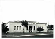
61 Bussell Hwy West Busselton
Cnr High St
Busselton Community Youth Centre
Sussex Road Board Office (fmr)
Busselton
South West
Constructed from 1936
| Type | Status | Date | Documents |
|---|---|---|---|
| (no listings) |
| Type | Status | Date | Documents |
|---|---|---|---|
| (no listings) |
| Type | Status | Date | Grading/Management | |
|---|---|---|---|---|
| Category | ||||
| Municipal Inventory | Adopted | 20 Jun 1996 | Category 2 | |
The building appears to be in good condition.
Individual Building or Group
| Epoch | General | Specific |
|---|---|---|
| Present Use | SOCIAL\RECREATIONAL | Other Community Hall\Centre |
| Original Use | GOVERNMENTAL | Office or Administration Bldg |
| Style |
|---|
| Inter-War Functionalist |
| Type | General | Specific |
|---|---|---|
| Roof | METAL | Other Metal |
| Wall | BRICK | Rendered Brick |
| General | Specific |
|---|---|
| SOCIAL & CIVIC ACTIVITIES | Government & politics |
| SOCIAL & CIVIC ACTIVITIES | Sport, recreation & entertainment |
This information is provided voluntarily as a public service. The information provided is made available in good faith and is derived from sources believed to be reliable and accurate. However, the information is provided solely on the basis that readers will be responsible for making their own assessment of the matters discussed herein and are advised to verify all relevant representations, statements and information.
Constructed from 1936
The Busselton and Districts Youth Centre has cultural heritage significance as the office of the Sussex Road Board prior to the formation of full local government and has sustained its social value as a youth centre. It is also one of a small number of examples of Inter-War Functionalist style buildings in Busselton.
Inter-War Functionalist style. The place is a single storey rendered brick and iron roofed road board office in the Inter- War Functionalist style with its main façade overlooking the Bussell Highway. Subsequent plantings have obscured much of the façade. It has a central squared entrance panel and is flanked by fenestrated flanking bays. The render work is banded and in recent times has been painted to emphasise the horizontal banding.
Donald & Son built the Sussex Roads Board Office in 1936. Until 1951, the district Local Government consisted of the Busselton Municipal Council, the boundaries of which were West St & Ford Road, and the Sussex Road Board. In 1951, the Municipality of Busselton was absorbed by a new Road Board to be called the “Busselton District Road Board”. This remained until 1961, when it became the “Busselton Shire Council”. In 1975, the new Civic Centre, housing the Busselton Shire Council, was opened on the corner of the Causeway and Southern Drive. The former Sussex Road Board office was re-opened as a Youth Centre.
Integrity Notes: The building no longer functions for its intended purpose but its presentation still belies its original use. The place retains a moderate degree of integrity. Authenticity Notes: There have been some adaptations made for its present use, but externally the place retains a moderate to high degree of authenticity. Moderate Degree/Moderate Degree
Good
| Owner | Category |
|---|---|
| Shire of Busselton | Local Gov't |
This information is provided voluntarily as a public service. The information provided is made available in good faith and is derived from sources believed to be reliable and accurate. However, the information is provided solely on the basis that readers will be responsible for making their own assessment of the matters discussed herein and are advised to verify all relevant representations, statements and information.
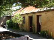
22 Kent St West Busselton
Bond Store & Custom Officer's Residence
The Gulch; Police Residence
Busselton
South West
Constructed from 1856
| Type | Status | Date | Documents |
|---|---|---|---|
| Heritage List | YES | 13 Aug 2014 | |
| State Register | Registered | 08 Jan 2010 | HCWebsite.Listing+ListingDocument, HCWebsite.Listing+ListingDocument |
| Type | Status | Date | Documents |
|---|---|---|---|
| (no listings) |
| Type | Status | Date | Grading/Management | |
|---|---|---|---|---|
| Category | ||||
| Register of the National Estate | Indicative Place | |||
| Classified by the National Trust | Recorded | 02 Feb 1976 | ||
| Municipal Inventory | Adopted | 20 Jun 1996 | Category 1 | |
Overall, the place is in fair condition. The condition of the place has deteriorated since the conservation plan was undertaken, largely as predicted by that plan. The roofing sheets are corroding and only one small section of unserviceable guttering remains insitu. Some cracks in the external render have enlarged to holes through which the hand-made bricks of the building can be seen eroding, exacerbated by water leakage from the c.1980s plumbing, rising damp and falling damp. A narrow garden bed runs along the front of the buildings (adding an additional source of potential moisture ingress) and there is some evidence of plants self-seeding along the other the walls. All the external doors are in poor condition and showing evidence of deterioration due to exposure to the elements. The door to Room Three (northern room) has entirely lost its glazing and one lower panel, and the remaining timber in warped and broken. Two of the sixteen glazed panels in the window to Room Two (central room) are missing. Internally, the pressed metal ceiling panels are rusting, especially in Room Three, and cracking and/or buckling, especially in Rooms One (south room) and Two. There is some deterioration of the timbers in the doorframe between Room Two and Room One. Internal rendering appears largely intact. It is not possible to determine the structural integrity of the bricks hidden by the rendering, although where cracks reveal them they are deteriorating. The place appears to be reasonably structurally sound. The house at 22 Kent Street, in whose backyard The Gulch is situated, is an Interwar weatherboard and fibrous cement residence, in good condition.
| Library Id | Title | Medium | Year Of Publication |
|---|---|---|---|
| 4072 | Conservation Plan for The Gulch. | Heritage Study {Cons'n Plan} | 1999 |
Individual Building or Group
| Epoch | General | Specific |
|---|---|---|
| Other Use | GOVERNMENTAL | Police Station or Quarters |
| Original Use | GOVERNMENTAL | Customs House\Bond Store |
| Present Use | RESIDENTIAL | Other |
| Style |
|---|
| Victorian Georgian |
| Federation Bungalow |
| Type | General | Specific |
|---|---|---|
| Wall | BRICK | Rendered Brick |
| Roof | METAL | Corrugated Iron |
| General | Specific |
|---|---|
| DEMOGRAPHIC SETTLEMENT & MOBILITY | Settlements |
| OUTSIDE INFLUENCES | Markets |
| OCCUPATIONS | Domestic activities |
| DEMOGRAPHIC SETTLEMENT & MOBILITY | Government policy |
| SOCIAL & CIVIC ACTIVITIES | Law & order |
| SOCIAL & CIVIC ACTIVITIES | Government & politics |
This information is provided voluntarily as a public service. The information provided is made available in good faith and is derived from sources believed to be reliable and accurate. However, the information is provided solely on the basis that readers will be responsible for making their own assessment of the matters discussed herein and are advised to verify all relevant representations, statements and information.
Constructed from 1854, Constructed from 1856
Custom officer’s house and police station 'The Gulch' has cultural heritage significance as one of the few remaining early private buildings designed in Victorian Georgian style in the town centre. It is also significant for its association with the early government administration of Busselton, in particular Captain John Molloy and Joseph Strelly Harris who were both resident magistrates for the Sussex District.
A rendered brick walled cottage with a steeply pitched iron roof at the rear of the lot and a timber framed and clad cottage at the front of the lot. There is also a low squat chimney located slightly off centre of the main ridge line. A three-roomed cottage with rendered brick walls inside and out. It has a pressed metal ceiling and concrete flooring. The roof was framed for shingles, which have been replaced with iron.
According to Busselton Historical Society notes, the place was built in the convict period as a customs officer’s residence and added to in 1906. John Molloy built the customs house during 1856, primarily as a warehouse space for bonded goods, with additional rooms for a guard and an office for the Resident Magistrate. Comments by the Colonial Secretary’s Office and Molloy and delays relating to its completion indicate that the building was purpose built. Subsequently a larger bond store and office space was built for the Resident Magistrate elsewhere and the place appears to have been used for residential purposes from 1861.
Moderate Degree/Moderate Degree Integrity Notes: The residential nature of the place remains apparent. The integrity of the place is moderate. Authenticity Notes: Both buildings have had minor modifications so that the place retains a moderate degree of authenticity.
Rear Cottage- Fair. Front Cottage- Good
| Ref ID No | Ref Name | Ref Source | Ref Date |
|---|---|---|---|
| Conservation Plan | 1999 |
| Owner | Category |
|---|---|
| D & J Yates | Other Private |
This information is provided voluntarily as a public service. The information provided is made available in good faith and is derived from sources believed to be reliable and accurate. However, the information is provided solely on the basis that readers will be responsible for making their own assessment of the matters discussed herein and are advised to verify all relevant representations, statements and information.
56 New River Ramble West Busselton
South of New River, North of Busselton Bypass, West of Fairview Dr, near Broardwater Golf Course.
Busselton
South West
Constructed from 1846 to 2002
| Type | Status | Date | Documents |
|---|---|---|---|
| Heritage List | YES | 13 Aug 2014 | |
| Heritage Agreement | YES | 05 May 2015 | HCWebsite.Listing+ListingDocument |
| Type | Status | Date | Documents |
|---|---|---|---|
| RHP - Assessed - Below Threshold | Current | 24 Mar 2005 |
| Type | Status | Date | Grading/Management | |
|---|---|---|---|---|
| Category | ||||
| Municipal Inventory | Adopted | 20 Jun 1996 | Category 2 | |
The place is in good condition.
Individual Building or Group
| Epoch | General | Specific |
|---|---|---|
| Present Use | FARMING\PASTORAL | Homestead |
| Original Use | INDUSTRIAL\MANUFACTURING | Other |
| Original Use | FARMING\PASTORAL | Homestead |
| Original Use | FARMING\PASTORAL | Kitchen |
| Style |
|---|
| Vernacular |
| Victorian Georgian |
| Type | General | Specific |
|---|---|---|
| Roof | METAL | Zincalume |
| Wall | BRICK | Other Brick |
| Wall | STONE | Limestone |
| General | Specific |
|---|---|
| OCCUPATIONS | Grazing, pastoralism & dairying |
| PEOPLE | Early settlers |
| OCCUPATIONS | Domestic activities |
This information is provided voluntarily as a public service. The information provided is made available in good faith and is derived from sources believed to be reliable and accurate. However, the information is provided solely on the basis that readers will be responsible for making their own assessment of the matters discussed herein and are advised to verify all relevant representations, statements and information.
Constructed from 2002, Constructed from 1846
Broadwater Homestead, a simple limestone cottage in the Victorian Georgian style has cultural heritage significance for its associations with Alfred Bussell for whom it was constructed between 1846 –48, who was MLA from 1870-74. The place is rare example of a simply designed Victorian Georgian homestead constructed in the early years of settlement. The residence characterises the early rural agricultural way of life.
Old farmhouse and out buildings with a close association with the Bussell family. Broadwater Homestead is a simple Victorian Georgian limestone cottage in the Victorian Georgian style. It also comprises a house (1985), kitchen wing (2000) and shed (2000), together with a store and these elements have no cultural heritage significance.
The place has long associations with the Bussell family and in particular with Alfred Pickmore Bussell, Member of the Legislative Council 1870-74. The Bussell family were among earliest settlers in the region.
Integrity Notes: The place remains in use as a residence and retains a high to moderate degree of integrity. Although still used as a private residence, it is no longer part of a farming property and all of the agricultural outbuildings have been removed. Authenticity Notes: The place has been altered extensively and retains a low degree of authenticity. Moderate-High Degree/Low Degree
Good
| Ref ID No | Ref Name | Ref Source | Ref Date |
|---|---|---|---|
| Heritage Council Assessment Documentation | 2005 |
| Owner | Category |
|---|---|
| MR Hair & CJ Packard | Other Private |
This information is provided voluntarily as a public service. The information provided is made available in good faith and is derived from sources believed to be reliable and accurate. However, the information is provided solely on the basis that readers will be responsible for making their own assessment of the matters discussed herein and are advised to verify all relevant representations, statements and information.